Difference between revisions of "2018-12-30 42 -78"
imported>Pedalpusher (new expedition report) |
imported>Pedalpusher (added pictures) |
||
| Line 18: | Line 18: | ||
== Photos == | == Photos == | ||
<gallery perrow="7"> | <gallery perrow="7"> | ||
| − | Image: | + | Image: 2018-12-30 Geohash Droid.jpg | Made it! |
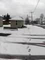
| − | Image: | + | Image: 2018-12-30 viewSouth.jpg | View South from the Hash. |
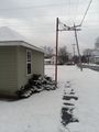
| − | Image: | + | Image: 2018-12-30 viewNorth.jpg | View North from the Hash (back toward School St). |
| − | Image: | + | Image: 2018-12-30 stupidGrin.jpg | Standard Stupid Grin. |
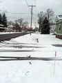
| − | Image: | + | Image: 2018-12-30 hashView.jpg | Walking back to the car, a look at the hash. It's just past that concrete barrier. |
| − | |||
| − | |||
| − | |||
</gallery> | </gallery> | ||
| Line 35: | Line 32: | ||
}} | }} | ||
| − | |||
[[Category:Expeditions]] | [[Category:Expeditions]] | ||
[[Category:Coordinates reached]] | [[Category:Coordinates reached]] | ||
| − | + | [[Category:Expeditions with photos]] | |
Revision as of 23:57, 1 January 2019
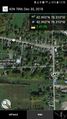
| Sun 30 Dec 2018 in 42,-78: 42.9933206, -78.3097163 geohashing.info google osm bing/os kml crox |
Contents
[hide]Location
On the sidewalk of Read Road in East Pembroke
Participants
Expedition
Thinking I could pick up one last hash for 2018, I thought about where else I could go after this hash so I wasn't driving 2 hours for a 2 minute stop. With Darien Lakes State Park pretty close to this hash, I figured it was finally time to explore this park.
In the morning, I did some cleaning, organizing and made some pizza dough so it would be ready by dinnertime. After making some lunch and writing down directions, I loaded the dogs into the car and we were off. Driving up Rt 219, I had to be careful since I saw there were a lot of cops about. Makes sense, they are looking for drunk drivers around the New Year. And while I do eventually want to randomly run into an officer at a hash, I certainly don't want to precipitate the meeting by being pulled over for speeding!
Arriving in East Pembroke, I turned on the HashDroid app on my phone. My faithful GPS that has served me well hashing over the years has started acting up and is no longer trustworthy. I ordered a new GPS and it should be arriving after the new year. I'm glad I had the app running or I would have missed my turn as the corner was not marked on the Read Road side. Turning down School Street right before the hash, I found a place to park and walked over to the hash. Since I was just popping out for a minute on the sidewalk, I left the dogs in the car for this one. Walking up to the hash, I easily got my pictures and headed back to the car.
We then made our way over to the State Park a short drive away and explored the trails for a little over 2 hours. Most were very wide ATV/Snow Mobile Trails, but I did find a piece of the Finger Lakes Trail that wound through the woods right before I had to turn around to head back to the car. It was really cool as I had the whole place to myself, although I'm sure that's not the case in the summer. It looks like its a very heavily used park, so I was glad to be able to explore it on my own terms and the dogs got to be off leash for some good exercise. As a bonus, the clouds broke up on the way back to the car and I got to enjoy the light of the setting sun.
Photos
Made it!
View South from the Hash.
View North from the Hash (back toward School St).

Standard Stupid Grin.
Walking back to the car, a look at the hash. It's just past that concrete barrier.


Ribbons
This user earned the Land geohash achievement
|