Difference between revisions of "2019-01-09 59 17"
imported>Fractal (Created page with "{{subst:Expedition |lat = 59 |lon = 17 |date = 2019-01-09 }}") |
imported>FippeBot m (Location) |
||
| (6 intermediate revisions by one other user not shown) | |||
| Line 1: | Line 1: | ||
| − | |||
| − | |||
| − | |||
| − | |||
| − | |||
| − | |||
| − | |||
| − | |||
| − | |||
| − | |||
{{meetup graticule | {{meetup graticule | ||
| lat=59 | | lat=59 | ||
| Line 14: | Line 4: | ||
| date=2019-01-09 | | date=2019-01-09 | ||
}} | }} | ||
| − | |||
| − | |||
__NOTOC__ | __NOTOC__ | ||
== Location == | == Location == | ||
| − | + | Between a small forest and a sort of lake, about an hour or two west of Stockholm by public transportation. | |
== Participants == | == Participants == | ||
| − | + | [[User:Fractal|Fractal]] ([[User talk:Fractal|talk]]) | |
| − | |||
== Plans == | == Plans == | ||
| − | + | I'm planning to get there in the morning, taking the bus 312 at 8:45 at Brommaplan. | |
== Expedition == | == Expedition == | ||
| − | + | Everything went as planned. I leaved from my home at about 7:45 and took one bus, two subways, and then one more bus. From there I only had 20 minutes more on foot to reach the hashpoint, most of it on roads and tracks, and then a few minutes in the forest. It was a nice day, lightly snowing but not really cold. When arriving towards the end of the road, I saw some sort of gate blocking the way, with fences on both sides, so I was afraid that I wouldn’t be able to go through, but it turned out that the gate was designed to allow pedestrians to go through, while making it impossible for cars or bikes or horses. | |
| − | + | The location of the hashpoint itself was very beautiful. It was at the entrance of a mostly frozen lake, with a small boat waiting for the spring. It was extremely quiet and I stayed there for a few minutes to enjoy the silence. I couldn’t stay too much though as there was only one bus per hour back to Stockholm and I didn’t want to miss it. | |
| − | |||
| − | == Photos == | + | == Photos == |
<!-- Insert pictures between the gallery tags using the following format: | <!-- Insert pictures between the gallery tags using the following format: | ||
Image:2012-##-## ## ## Alpha.jpg | Witty Comment | Image:2012-##-## ## ## Alpha.jpg | Witty Comment | ||
--> | --> | ||
| − | <gallery perrow=" | + | <gallery perrow="4" widths=250px heights=250px> |
| + | Image:2019-01-09_59_17-1.jpg | After getting off the last bus, 20 minutes to go! | ||
| + | Image:2019-01-09_59_17-7.jpg | The gate protecting the hashpoint | ||
| + | Image:2019-01-09_59_17-2.jpg | First sighting of the lake | ||
| + | Image:2019-01-09_59_17-3.jpg | The lake itself | ||
| + | Image:2019-01-09_59_17-4.jpg | The lake with the boat | ||
| + | Image:2019-01-09_59_17-9.png | Proof | ||
| + | Image:2019-01-09_59_17-5.jpg | Me at the hashpoint | ||
| + | Image:2019-01-09_59_17-6.jpg | A bird house on the way back | ||
| + | Image:2019-01-09_59_17-8.jpg | Some horses dressed for the weather | ||
</gallery> | </gallery> | ||
| − | |||
| − | |||
| − | |||
| − | |||
| − | |||
| − | |||
| − | |||
| − | |||
| − | |||
| − | |||
| − | |||
| − | |||
| − | |||
| − | |||
| − | |||
| − | |||
| − | |||
| − | |||
[[Category:Expeditions]] | [[Category:Expeditions]] | ||
| − | |||
[[Category:Expeditions with photos]] | [[Category:Expeditions with photos]] | ||
| − | |||
| − | |||
| − | |||
| − | |||
| − | |||
| − | |||
| − | |||
[[Category:Coordinates reached]] | [[Category:Coordinates reached]] | ||
| − | + | {{location|SE|AB}} | |
| − | |||
| − | |||
| − | |||
| − | |||
| − | |||
| − | |||
| − | |||
| − | |||
| − | |||
| − | |||
| − | |||
| − | |||
| − | |||
| − | |||
| − | |||
| − | |||
| − | |||
Latest revision as of 04:24, 16 August 2019
| Wed 9 Jan 2019 in 59,17: 59.2827813, 17.6968347 geohashing.info google osm bing/os kml crox |
Location
Between a small forest and a sort of lake, about an hour or two west of Stockholm by public transportation.
Participants
Plans
I'm planning to get there in the morning, taking the bus 312 at 8:45 at Brommaplan.
Expedition
Everything went as planned. I leaved from my home at about 7:45 and took one bus, two subways, and then one more bus. From there I only had 20 minutes more on foot to reach the hashpoint, most of it on roads and tracks, and then a few minutes in the forest. It was a nice day, lightly snowing but not really cold. When arriving towards the end of the road, I saw some sort of gate blocking the way, with fences on both sides, so I was afraid that I wouldn’t be able to go through, but it turned out that the gate was designed to allow pedestrians to go through, while making it impossible for cars or bikes or horses.
The location of the hashpoint itself was very beautiful. It was at the entrance of a mostly frozen lake, with a small boat waiting for the spring. It was extremely quiet and I stayed there for a few minutes to enjoy the silence. I couldn’t stay too much though as there was only one bus per hour back to Stockholm and I didn’t want to miss it.
Photos
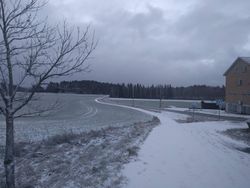
After getting off the last bus, 20 minutes to go!
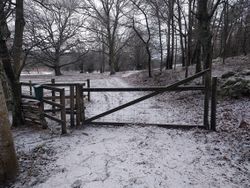
The gate protecting the hashpoint
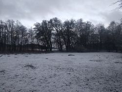
First sighting of the lake
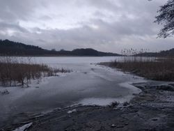
The lake itself
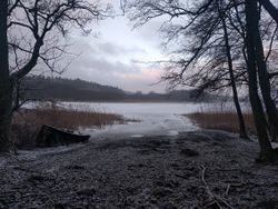
The lake with the boat
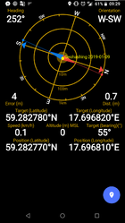
Proof
- Error creating thumbnail: Unable to save thumbnail to destination
Me at the hashpoint
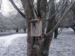
A bird house on the way back
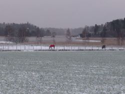
Some horses dressed for the weather


