Difference between revisions of "2019-05-18 50 11"
imported>Reinhard (report I) |
imported>FippeBot m (Location) |
||
| (One intermediate revision by one other user not shown) | |||
| Line 21: | Line 21: | ||
== Tracklog == | == Tracklog == | ||
| − | [https://www.strava.com/activities/ | + | [https://www.strava.com/activities/2378098296 Strava activity] |
== Photos == | == Photos == | ||
| Line 33: | Line 33: | ||
[[Category:Expeditions with photos]] | [[Category:Expeditions with photos]] | ||
[[Category:Coordinates reached]] | [[Category:Coordinates reached]] | ||
| + | {{location|DE|TH|AP}} | ||
Latest revision as of 03:43, 7 August 2019
| Sat 18 May 2019 in 50,11: 50.9395597, 11.4087029 geohashing.info google osm bing/os kml crox |
Location
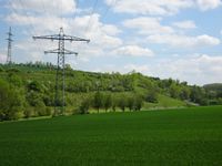
On a field beneath power lines between Mellingen and Lehnstedt, Thuringia, Germany.
Participants
Expedition
Due to good weather after a cold and rainy period Reinhard planned to cycle from Jena to Schleusingerneundorf crabwise. Looking up the hashpoints very quickly concretized his plans. The 50/11 geohash was on the shortest route and only 19 km from the start close to the road from Lehnstedt to Mellingen he has taken hundreds of times. As there was still a detour to be found he looked 70 km westward to find a hashpoint in 50/10 also conveniently located on a field and close to a road. Taking a pleasant route for road cycling it was 88 km distance. From there it will still be around 83 km to Schleusingerneundorf making it 190 km altogether.
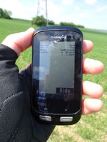
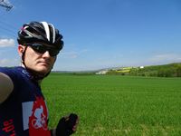
The plan sounded reasonably and the weather turned out perfect. After a late breakfast with his family in Jena he headed to hashpoint number one and quickly took the photos for proof before continuing his double mission ...
Tracklog
Photos
|


