Difference between revisions of "2019-06-25 52 8"
imported>GeorgDerReisende (new report) |
imported>FippeBot m (Location) |
||
| (One intermediate revision by one other user not shown) | |||
| Line 1: | Line 1: | ||
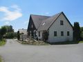
| + | [[Image:{{{image|2019-06-25 52 8 GeorgDerReisende 0001.jpg}}}|thumb|left]] | ||
| − | |||
| − | |||
| − | |||
| − | |||
| − | |||
| − | |||
| − | |||
| − | |||
| − | |||
{{meetup graticule | {{meetup graticule | ||
| lat=52 | | lat=52 | ||
| Line 19: | Line 11: | ||
== Location == | == Location == | ||
| − | + | ||
| + | The hash lay at the crossing of Krukumer Straße, Elmsbrink and Kottebrink in Melle. | ||
== Participants == | == Participants == | ||
| − | + | ||
| − | + | [[User:GeorgDerReisende|GeorgDerReisende]] | |
== Plans == | == Plans == | ||
| − | + | ||
| + | Using public transport to go to the hash and using public transport to go home. | ||
== Expedition == | == Expedition == | ||
| − | |||
| − | + | I left home at 7 o'clock and with tram, tram, train, train, bus, train, train and bus I arrived near the hash. I walked to the place, took some photos and... tried to travel home. Between Bielefeld and Paderborn the train stopped for 40 minutes ("Signalstörung") and with that I missed a good train home. I tried a detour, but at Bad Karlshafen was the bridge closed for buses and the walk needed five minutes longer than the bus would wait. So I had to wait there for an hour and arrived only half an hour earlier than the original way with two hours waiting. | |
| − | |||
== Photos == | == Photos == | ||
| − | |||
| − | |||
| − | |||
<gallery perrow="5"> | <gallery perrow="5"> | ||
| + | 2019-06-25 52 8 GeorgDerReisende 1319.jpg | arrived! | ||
| + | 2019-06-25 52 8 GeorgDerReisende 1376.jpg | the junction with the hash | ||
| + | 2019-06-25 52 8 GeorgDerReisende 1377.jpg | looking north with the hash | ||
| + | 2019-06-25 52 8 GeorgDerReisende 1381.jpg | looking west | ||
| + | 2019-06-25 52 8 GeorgDerReisende 1382.jpg | looking south | ||
| + | 2019-06-25 52 8 GeorgDerReisende 1383.jpg | looking east | ||
| + | 2019-06-25 52 8 GeorgDerReisende 1384.jpg | some grin | ||
</gallery> | </gallery> | ||
| − | + | [[Category:Expeditions]] | |
| − | |||
| − | |||
| − | + | [[Category:Expeditions with photos]] | |
| − | |||
| − | [[Category: | ||
| − | + | [[Category:Expedition without GPS]] | |
| − | |||
| − | |||
| − | |||
| − | [[Category:Expedition | ||
| − | |||
| − | |||
| − | |||
| − | |||
| − | |||
| − | |||
| − | |||
| − | |||
| − | |||
| − | |||
| − | |||
| − | |||
[[Category:Coordinates reached]] | [[Category:Coordinates reached]] | ||
| − | + | {{location|DE|NI|OS}} | |
| − | |||
| − | |||
| − | |||
| − | |||
| − | |||
| − | |||
| − | |||
| − | |||
| − | |||
| − | |||
| − | |||
| − | |||
| − | |||
| − | |||
| − | |||
| − | |||
| − | |||
Latest revision as of 12:47, 14 July 2019

| Tue 25 Jun 2019 in 52,8: 52.2097356, 8.4088163 geohashing.info google osm bing/os kml crox |
Location
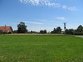
The hash lay at the crossing of Krukumer Straße, Elmsbrink and Kottebrink in Melle.
Participants
Plans
Using public transport to go to the hash and using public transport to go home.
Expedition
I left home at 7 o'clock and with tram, tram, train, train, bus, train, train and bus I arrived near the hash. I walked to the place, took some photos and... tried to travel home. Between Bielefeld and Paderborn the train stopped for 40 minutes ("Signalstörung") and with that I missed a good train home. I tried a detour, but at Bad Karlshafen was the bridge closed for buses and the walk needed five minutes longer than the bus would wait. So I had to wait there for an hour and arrived only half an hour earlier than the original way with two hours waiting.
Photos
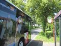
arrived!
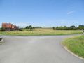
the junction with the hash
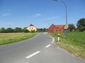
looking north with the hash
looking west
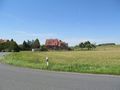
looking south
looking east
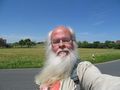
some grin


