Difference between revisions of "2019-08-09 51 6"
From Geohashing
imported>GeorgDerReisende (new report) |
imported>FippeBot m (Location) |
||
| (One intermediate revision by one other user not shown) | |||
| Line 1: | Line 1: | ||
| − | |||
| − | |||
| − | |||
| − | |||
| − | |||
| − | |||
| − | |||
| − | |||
| − | |||
| − | |||
{{meetup graticule | {{meetup graticule | ||
| lat=51 | | lat=51 | ||
| Line 19: | Line 9: | ||
== Location == | == Location == | ||
| − | + | ||
| + | The hash lay at the Dietrich-Bonhoeffer-Church at the Einsteinstraße in Neuss. | ||
== Participants == | == Participants == | ||
| − | + | ||
| − | + | [[User:GeorgDerReisende|GeorgDerReisende]] | |
== Plans == | == Plans == | ||
| − | + | ||
| + | Traveling and walking. | ||
== Expedition == | == Expedition == | ||
| − | |||
| − | + | Tram, train, train, bus. And a short walk. The church was smaller then expected. I think, standing at the bushes was near enough. I didn't want to climb the scaffold. | |
| − | |||
== Photos == | == Photos == | ||
| − | |||
| − | |||
| − | |||
<gallery perrow="5"> | <gallery perrow="5"> | ||
| + | 2019-08-09 51 6 GeorgDerReisende 5664.jpg | arrived by bus | ||
| + | 2019-08-09 51 6 GeorgDerReisende 5667.jpg | the church | ||
| + | 2019-08-09 51 6 GeorgDerReisende 5669.jpg | the bushes in front of the church | ||
| + | 2019-08-09 51 6 GeorgDerReisende 5670.jpg | nearest place | ||
| + | 2019-08-09 51 6 GeorgDerReisende 5671.jpg | looking west | ||
| + | 2019-08-09 51 6 GeorgDerReisende 5672.jpg | looking south | ||
| + | 2019-08-09 51 6 GeorgDerReisende 5674.jpg | looking east | ||
| + | 2019-08-09 51 6 GeorgDerReisende 5673.jpg | the geohasher | ||
</gallery> | </gallery> | ||
| − | + | [[Category:Expeditions]] | |
| − | |||
| − | |||
| − | + | [[Category:Expeditions with photos]] | |
| − | |||
| − | [[Category: | ||
| − | + | [[Category:Expedition without GPS]] | |
| − | |||
| − | |||
| − | |||
| − | |||
| − | |||
| − | |||
| − | |||
| − | |||
| − | |||
| − | |||
| − | |||
| − | |||
| − | |||
| − | |||
| − | |||
| − | |||
[[Category:Coordinates reached]] | [[Category:Coordinates reached]] | ||
| − | + | {{location|DE|NW|GV}} | |
| − | |||
| − | |||
| − | |||
| − | |||
| − | |||
| − | |||
| − | |||
| − | |||
| − | |||
| − | |||
| − | |||
| − | |||
| − | |||
| − | |||
| − | |||
| − | |||
| − | |||
Latest revision as of 20:42, 11 August 2019
| Fri 9 Aug 2019 in 51,6: 51.1844948, 6.6732549 geohashing.info google osm bing/os kml crox |
Location
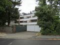
The hash lay at the Dietrich-Bonhoeffer-Church at the Einsteinstraße in Neuss.
Participants
Plans
Traveling and walking.
Expedition
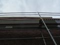
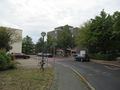
Tram, train, train, bus. And a short walk. The church was smaller then expected. I think, standing at the bushes was near enough. I didn't want to climb the scaffold.
Photos
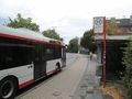
arrived by bus
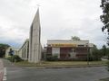
the church
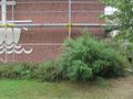
the bushes in front of the church
nearest place
looking west
looking south
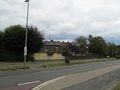
looking east
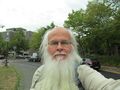
the geohasher


