Difference between revisions of "File:Benjw hashmap.png"
From Geohashing
imported>Benjw (uploaded a new version of "File:Benjw hashmap.png": Update to 14 September 2012; also show only those hashes close to home.) |
(Maintenance script uploaded File:Benjw hashmap.png) |
||
| (5 intermediate revisions by one other user not shown) | |||
| Line 1: | Line 1: | ||
| − | Map of [[User:Benjw|Benjw]]'s geohashing expeditions -- by car (red), bike | + | Map of [[User:Benjw|Benjw]]'s nearest geohashing expeditions -- by car (red), bike (green), public transport (blue) and unsuccessful (grey). Home is at the centre of the map; my graticule ([[52,0]]) is outlined. Also see [[:File:Benjw hashmap 2.png]] for a whole-country view of my expeditions. |
[[Category:Maps]][[Category:Photos by Benjw]] | [[Category:Maps]][[Category:Photos by Benjw]] | ||
Latest revision as of 14:44, 30 January 2020
Map of Benjw's nearest geohashing expeditions -- by car (red), bike (green), public transport (blue) and unsuccessful (grey). Home is at the centre of the map; my graticule (52,0) is outlined. Also see File:Benjw hashmap 2.png for a whole-country view of my expeditions.
File history
Click on a date/time to view the file as it appeared at that time.
| Date/Time | Thumbnail | Dimensions | User | Comment | |
|---|---|---|---|---|---|
| current | 14:44, 30 January 2020 | 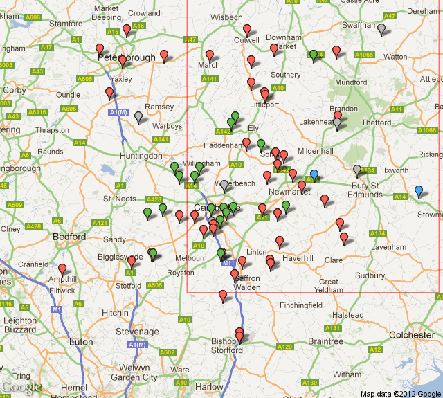 | 640 × 575 (131 KB) | Maintenance script (talk | contribs) |
- You cannot overwrite this file.
File usage
The following page links to this file: