Difference between revisions of "2008-06-06 44 -92"
From Geohashing
imported>MarkTraceur (→Pictures) |
imported>FippeBot m (Location) |
||
| (2 intermediate revisions by 2 users not shown) | |||
| Line 14: | Line 14: | ||
Image:2008-06-06-44--92-002.jpg|Considering venturing into the field...We didn't. | Image:2008-06-06-44--92-002.jpg|Considering venturing into the field...We didn't. | ||
</gallery> | </gallery> | ||
| − | |||
[[Category:Expeditions]] | [[Category:Expeditions]] | ||
| + | [[Category:Expeditions with photos]] | ||
| + | [[Category:Coordinates reached]] | ||
| + | {{location|US|MN|WH}} | ||
Latest revision as of 04:47, 7 August 2019
| Fri 6 Jun 2008 in 44,-92: 44.7596630, -92.8253824 geohashing.info google osm bing/os kml crox |
Description
Today's point fell in a field. We had scouted it out fairly well and did not feel like killing the corn stalks that seemed to be in the early stages of growth, so we took a pass on the actual point, but we successfully reached it apart from respect for the labor of the owners of the field. Geohashers who made it: Scott, Mark, Nicholas, and Sammy.
Pictures
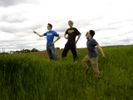
Posing at the point.
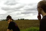
Considering venturing into the field...We didn't.

