Difference between revisions of "2010-10-23 60 10"
From Geohashing
imported>Relet m |
m (2020-01-01 update) |
||
| (2 intermediate revisions by 2 users not shown) | |||
| Line 1: | Line 1: | ||
| − | |||
| − | |||
| − | |||
| − | |||
| − | |||
| − | |||
| − | |||
| − | |||
| − | |||
{{meetup graticule | {{meetup graticule | ||
| lat=60 | | lat=60 | ||
| Line 13: | Line 4: | ||
| date=2010-10-23 | | date=2010-10-23 | ||
}} | }} | ||
| − | |||
| − | |||
__NOTOC__ | __NOTOC__ | ||
== Location == | == Location == | ||
| Line 31: | Line 20: | ||
*This is starting to be fun! Now cycling exclusively on snow and ice. :) -- [[User:relet|relet]] [http://www.openstreetmap.org/?lat=60.122079849243164&lon=10.378013849258423&zoom=16&layers=B000FTF @60,1221,10,3780] 13:25, 23 Oktober 2010 (MESZ) | *This is starting to be fun! Now cycling exclusively on snow and ice. :) -- [[User:relet|relet]] [http://www.openstreetmap.org/?lat=60.122079849243164&lon=10.378013849258423&zoom=16&layers=B000FTF @60,1221,10,3780] 13:25, 23 Oktober 2010 (MESZ) | ||
| − | |||
| − | |||
== Photos == | == Photos == | ||
| − | |||
| − | |||
| − | |||
<gallery perrow="5"> | <gallery perrow="5"> | ||
| Line 48: | Line 32: | ||
Image:2010-10-23_60_10_14-14-45-675.jpg | Steinsfjorden again... [http://www.openstreetmap.org/?lat=60.128313302993774&lon=10.350666046142578&zoom=16&layers=B000FTF @60,1283,10,3507] | Image:2010-10-23_60_10_14-14-45-675.jpg | Steinsfjorden again... [http://www.openstreetmap.org/?lat=60.128313302993774&lon=10.350666046142578&zoom=16&layers=B000FTF @60,1283,10,3507] | ||
</gallery> | </gallery> | ||
| − | |||
| − | |||
| − | |||
| − | |||
| − | |||
[[Category:Expeditions]] | [[Category:Expeditions]] | ||
[[Category:Expeditions with photos]] | [[Category:Expeditions with photos]] | ||
[[Category:Coordinates not reached]] | [[Category:Coordinates not reached]] | ||
| − | [[Category:Not reached - | + | [[Category:Not reached - Time constraints]] |
| + | {{location|NO|30}} | ||
Latest revision as of 00:26, 16 February 2020
| Sat 23 Oct 2010 in 60,10: 60.0998277, 10.5484724 geohashing.info google osm bing/os kml crox |
Location
On the shore of a lake, somewhere deep in the Northern Forest (Nordmarka, northern relative to Oslo).
Participants
Plans
Cycle towards the hash, and then test how waterproof the boots are.
Expedition
I cycled, but not far.
- Cycling uphills should be more fun than downhills at these temperatures. I'm still fighting mainly with my motivation. :P I hope some of the sights can make up for that. -- relet @60,1253,10,3597 13:05, 23 Oktober 2010 (MESZ)
- This is starting to be fun! Now cycling exclusively on snow and ice. :) -- relet @60,1221,10,3780 13:25, 23 Oktober 2010 (MESZ)
Photos
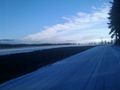
I think I am headed towards more cloudy weather. @60,1485,10,2685
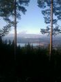
Steinsfjorden @60,1206,10,3785
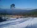
Call me boring, but I don't feel like going far today. Not even sure which category that will fit in. @60,1205,10,3864

Steinsfjorden again... @60,1283,10,3507


