Difference between revisions of "2008-06-17 45 -92"
From Geohashing
imported>MarkTraceur (New page: {{meetup graticule | map=<map lat="45" lon="-92" date="2008-06-17" /> | lat=45 | lon=-92 | date=2008-06-17 }} Reached by Mark. It was about 400 feet from the road. I ...) |
imported>Thomcat (Success/failure category added) |
||
| Line 17: | Line 17: | ||
Image:2008-06-17-45--93-03.jpg|The marker. I'm going to bring my own stick next time, I had to steal a broken corn stalk. | Image:2008-06-17-45--93-03.jpg|The marker. I'm going to bring my own stick next time, I had to steal a broken corn stalk. | ||
</gallery> | </gallery> | ||
| + | |||
| + | [[Category:Expeditions]] | ||
| + | [[Category:Expeditions with photos]] | ||
| + | [[Category:Coordinates reached]] | ||
Revision as of 14:15, 11 August 2008
| Tue 17 Jun 2008 in 45,-92: 45.1345941, -92.9117026 geohashing.info google osm bing/os kml crox |
Reached by Mark. It was about 400 feet from the road. I ran into a field, took pictures, placed a marker (thanks, MA geohashers, for the idea!), and jogged back to my car.
Pictures
The GPS picture is not readable, because my GPS reflects, so the camera can't autofocus...but the other two are fine.
My GPS being all reflective. Maybe it's polarized....working on it....

Grinning like an idiot. Not a great picture.
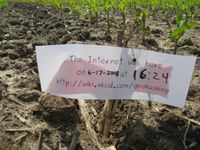
The marker. I'm going to bring my own stick next time, I had to steal a broken corn stalk.


