Difference between revisions of "2008-06-20 55 13"
imported>Thomcat (Success/failure category added) |
imported>FippeBot m (Location) |
||
| (One intermediate revision by one other user not shown) | |||
| Line 28: | Line 28: | ||
[[Category:Expeditions with photos]] | [[Category:Expeditions with photos]] | ||
[[Category:Coordinates not reached]] | [[Category:Coordinates not reached]] | ||
| − | [[Category: | + | [[Category:Not reached - No public access]] |
| + | {{location|SE|M}} | ||
Latest revision as of 05:16, 7 August 2019
| Fri 20 Jun 2008 in 55,13: 55.8812831, 13.0866544 geohashing.info google osm bing/os kml crox |
About
This hash in the Malmö, Sweden graticule was located north of Teckomatorp. Once again in a wheat field. As you can see from the "no traffic allowed"-sign in the
images below, we couldn't get closer than a couple of hundreds of meters. Just like three other times, the point was in a wheat field.
GPS: (55.881283082188N, 13.0866543637585E).
The Meetup
HannesL enjoyed the drive there. David enjoyed the ride in Hannes' car. HannesL is glad he's a vegetarian, since that
compensates for the carbon dioxide emissions of his car when driving to the hashpoints.
- Photo Gallery
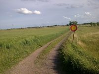
No traffic enters here. Sure we could have walked, but still...
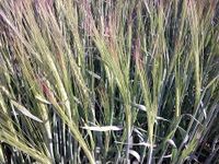
Wheat field once again. 4 out of 5 reached points have been in wheat fields.
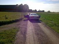
The official Geohash-car!
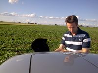
]] getting in the car after the point was reached.


