Difference between revisions of "2008-06-22 -37 175"
From Geohashing
imported>InvaluableKiwi (New page: {{meetup graticule | map=<map lat="-37" lon="175" date="2008-06-22" /> | lat=-37 | lon=175 | date=2008-06-22 }} ==Location== Back of a house overlooking a gully in Queenwood. ==Report== ...) |
imported>FippeBot m (Location) |
||
| (4 intermediate revisions by 3 users not shown) | |||
| Line 6: | Line 6: | ||
}} | }} | ||
| + | {{land geohash | latitude = -37 | longitude = 175 | date = 2008-06-22 | name = InvaluableKiwi | image = 22-06-2008_-37_175_grinninglikeidiots.JPG}} | ||
==Location== | ==Location== | ||
Back of a house overlooking a gully in Queenwood. | Back of a house overlooking a gully in Queenwood. | ||
| Line 19: | Line 20: | ||
Image:22-06-2008_-37_175_date.JPG | Image:22-06-2008_-37_175_date.JPG | ||
</gallery> | </gallery> | ||
| − | |||
[[Category:Expeditions]] | [[Category:Expeditions]] | ||
[[Category:Expeditions with photos]] | [[Category:Expeditions with photos]] | ||
| + | [[Category:Coordinates reached]] | ||
| + | [[Category:Ambassador achievement]] | ||
| + | {{location|NZ|WKO}} | ||
Latest revision as of 05:23, 7 August 2019
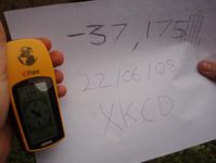
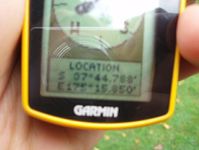
| Sun 22 Jun 2008 in -37,175: -37.7465293, 175.2642328 geohashing.info google osm bing/os kml crox |
InvaluableKiwi earned the Land geohash achievement
|
Location
Back of a house overlooking a gully in Queenwood.
Report
InvaluableKiwi and brother turned up at 4 o'clock in the hopes of meeting other geohashers. Unfortunately no-one showed, but the homeowner was kind enough to let us in. Good practice for working with the GPS, and nice to have a hash that's not 30km away for once.
Pictures
- Pictures, click for more details.