Difference between revisions of "2008-06-22 47 19"
From Geohashing
imported>Tomtom |
imported>Tomtom |
||
| Line 16: | Line 16: | ||
== Pictures == | == Pictures == | ||
<gallery caption="the day of the lone rider" widths="150px" heights="150px" perrow="3"> | <gallery caption="the day of the lone rider" widths="150px" heights="150px" perrow="3"> | ||
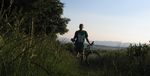
| − | Image:2008_06_22_47_19_rider.jpg| | + | Image:2008_06_22_47_19_rider.jpg|approaching the hashpoint |
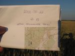
| + | Image:2008_06_22_47_19_paper.jpg|at the site | ||
</gallery> | </gallery> | ||
[[Category:Expeditions]] | [[Category:Expeditions]] | ||
[[Category:Expeditions_with_photos]] | [[Category:Expeditions_with_photos]] | ||
Revision as of 23:08, 22 June 2008
| Sun 22 Jun 2008 in Budapest, Hungary: 47.7465293, 19.2642328 geohashing.info google osm bing/os kml crox |
Location
The hashpoint for the graticule was near Vác, between the villages called Váchartyán and Kisnémedi, outside residental areas, on the side of a mound among maize and rape fields, in a small forest of pines.
Expedition
I rode my bike from home to the site. (You can check out my path here, it was a total of 63.9 km / 39.71 mi) The first part of the journey was quite easy, on bike lanes and roads, the close approach made me a bit more sweaty, with up and downhills on dirt roads.
Pictures
- the day of the lone rider
approaching the hashpoint
at the site

