Difference between revisions of "2012-01-13 59 15"
imported>Cjk ([retro picture] Home again) |
m (Eliminating redlinks) |
||
| (14 intermediate revisions by 4 users not shown) | |||
| Line 1: | Line 1: | ||
| + | [[Image:{{{image|2012-01-13_59_15_16-33-07-068.jpg}}}|thumb|left]] | ||
| − | |||
| − | |||
| − | |||
| − | |||
| − | |||
| − | |||
| − | |||
| − | |||
| − | |||
{{meetup graticule | {{meetup graticule | ||
| lat=59 | | lat=59 | ||
| Line 19: | Line 11: | ||
== Location == | == Location == | ||
<!-- where you've surveyed the hash to be --> | <!-- where you've surveyed the hash to be --> | ||
| + | It looked like it was in a field near a road near Fagersta. | ||
== Participants == | == Participants == | ||
<!-- who attended --> | <!-- who attended --> | ||
| + | [[User:Cjk|Carl-Johan]] | ||
== Plans == | == Plans == | ||
<!-- what were the original plans --> | <!-- what were the original plans --> | ||
| + | It looked like a nice little drive from [[2012-01-13 58 15]] and then on the way back home I could try {{egl|2012-01-13|59|16}} and {{egl|2012-01-13|59|17}}. | ||
| + | |||
| + | |||
| + | I reached these 4 of my planned graticules. | ||
| + | |||
| + | *[[2012-01-13 58 17]] | ||
| + | *[[2012-01-13 58 16]] | ||
| + | *[[2012-01-13 58 15]] | ||
| + | *[[2012-01-13 59 15]] | ||
== Expedition == | == Expedition == | ||
<!-- how it all turned out. your narrative goes here. --> | <!-- how it all turned out. your narrative goes here. --> | ||
| + | So much for planning. I the real world it was almost 15:00 which means almost no daylight left. And it was snowing. And the roads past Vingåker was really twisty. But I headed north. Google maps led me into some weird paths. One through the center of Kungsör over a very narrow bridge, and one take me on the East side of the lake Långsvan instead of using the main road on the West side. Both times I missed the exit and had to turn around. And the road east of Långsvan was dodgy as hell. Moisture was freezing on the ground so slow through the corners. | ||
| + | |||
| + | I found the exit towards the hash, and turned in on a very tiny gravel road. Only it wasn't gravel anymore. Going 5 km/h the back end started to slip a bit since it was pure ICE! The whole road. Luckily they had some sand on top as well but slow slow slow was the key. It started to dip downwards and you think; am I gonna be able to get up. turned left at a farm and now it was steepening. Too afraid of not being able to get back up I parked the car and started walking. Forgot to put on my IceBug shoes with studs. Damn. It would have been nice. | ||
| + | |||
| + | Turns out the geohash wasn't in the field, but in a clearcut on a hill. hiked to the geohash and took some pictures. It was dark and freezing. Made a HUGE xkcd with some large branches. | ||
| + | |||
| + | By now, I was tired, and I had to be back in Stockholm in time for a party, so I decided to skip the next two planned geohashes on the was back. The roads to them where twisty and icy and not going in nice lines but would have added a really long detour compared to the straight road going straight home. | ||
| + | |||
| + | Google Maps tricked me again and led me onto a private road between the main roads leading to Fagersta. This was TONS of fun! it was super tight and pure pure ice. If you just touched the handbrake in a turn the back end came slowly gliding behind you around the corners. Opposite lock and some gas and you recovered onto the new trajectory. Then a fairly uneventful drive back home on the E18 once i reached it. | ||
| − | + | I didn't get a Monster hash, but a Ultra hash was super nice! | |
| − | |||
== Photos == | == Photos == | ||
| Line 38: | Line 49: | ||
<gallery perrow="5"> | <gallery perrow="5"> | ||
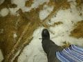
| − | Image:2012-01-13_59_15_16-33-07-068.jpg | I be Don [http://www.openstreetmap.org/?lat=59.92612906&lon=15.83815447&zoom=16&layers=B000FTF @59.9261,15.8382] | + | Image:2012-01-13_59_15_16-33-07-068.jpg | I be [http://www.tgrec.com/bands/band.php?id=10 Don! (Caballero)][http://www.openstreetmap.org/?lat=59.92612906&lon=15.83815447&zoom=16&layers=B000FTF @59.9261,15.8382] |
| − | |||
Image:2012-01-13_59_15_00-40-26-674.jpg | Fuzzy, cold | Image:2012-01-13_59_15_00-40-26-674.jpg | Fuzzy, cold | ||
| Line 59: | Line 69: | ||
Image:2012-01-13_59_15_00-46-20-485.jpg | Home again | Image:2012-01-13_59_15_00-46-20-485.jpg | Home again | ||
| + | |||
| + | Image:2012-01-13_59_15_00-47-05-288.jpg | Tired Ultra hasher | ||
</gallery> | </gallery> | ||
| Line 64: | Line 76: | ||
{{#vardefine:ribbonwidth|800px}} | {{#vardefine:ribbonwidth|800px}} | ||
<!-- Add any achievement ribbons you earned below, or remove this section --> | <!-- Add any achievement ribbons you earned below, or remove this section --> | ||
| + | {{land geohash | latitude = 59 | longitude = 15 | date = 2012-01-13 | name = Carl-Johan | image = 2012-01-13_59_15_16-33-07-068.jpg }} | ||
| + | {{Frozen Geohash | latitude = 59 | longitude = 15 | date = 2012-01-13 | | name = Carl-Johan | image = 2012-01-13_59_15_00-44-59-497.jpg }} | ||
| + | {{Minesweeper geohash | graticule = Norrköping, Sweden | ranknumber = 4 | w = true | ne = true | e = true | nw = true| name = Carl-Johan }} | ||
| + | {{Multihash2 | count = 4 | date = 2012-01-13 | name = Carl-Johan | image = 2012-01-13_59_15_00-47-05-288.jpg }} | ||
| + | {{police geohash | latitude = 58 | longitude = 16 | date = 2012-01-13 | encounter = riding behind cop car on freeway | name = Carl-Johan | image = 2012-01-13_58_16_02-56-13-803.jpg }} | ||
| − | + | [[Category:Expeditions]] | |
| − | |||
| − | |||
| − | |||
| − | |||
| − | |||
| − | |||
| − | |||
| − | |||
| − | |||
| − | |||
| − | [[Category:Expeditions]] | ||
| − | |||
[[Category:Expeditions with photos]] | [[Category:Expeditions with photos]] | ||
| − | |||
| − | |||
| − | |||
| − | |||
| − | |||
[[Category:Coordinates reached]] | [[Category:Coordinates reached]] | ||
| − | + | {{location|SE|U}} | |
| − | |||
| − | |||
| − | |||
| − | |||
| − | |||
| − | |||
| − | |||
| − | |||
| − | |||
Latest revision as of 13:37, 21 March 2020

| Fri 13 Jan 2012 in 59,15: 59.9261262, 15.8381610 geohashing.info google osm bing/os kml crox |
Location
It looked like it was in a field near a road near Fagersta.
Participants
Plans
It looked like a nice little drive from 2012-01-13 58 15 and then on the way back home I could try 2012-01-13 59 16 and 2012-01-13 59 17.
I reached these 4 of my planned graticules.
Expedition
So much for planning. I the real world it was almost 15:00 which means almost no daylight left. And it was snowing. And the roads past Vingåker was really twisty. But I headed north. Google maps led me into some weird paths. One through the center of Kungsör over a very narrow bridge, and one take me on the East side of the lake Långsvan instead of using the main road on the West side. Both times I missed the exit and had to turn around. And the road east of Långsvan was dodgy as hell. Moisture was freezing on the ground so slow through the corners.
I found the exit towards the hash, and turned in on a very tiny gravel road. Only it wasn't gravel anymore. Going 5 km/h the back end started to slip a bit since it was pure ICE! The whole road. Luckily they had some sand on top as well but slow slow slow was the key. It started to dip downwards and you think; am I gonna be able to get up. turned left at a farm and now it was steepening. Too afraid of not being able to get back up I parked the car and started walking. Forgot to put on my IceBug shoes with studs. Damn. It would have been nice.
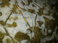
Turns out the geohash wasn't in the field, but in a clearcut on a hill. hiked to the geohash and took some pictures. It was dark and freezing. Made a HUGE xkcd with some large branches.
By now, I was tired, and I had to be back in Stockholm in time for a party, so I decided to skip the next two planned geohashes on the was back. The roads to them where twisty and icy and not going in nice lines but would have added a really long detour compared to the straight road going straight home.
Google Maps tricked me again and led me onto a private road between the main roads leading to Fagersta. This was TONS of fun! it was super tight and pure pure ice. If you just touched the handbrake in a turn the back end came slowly gliding behind you around the corners. Opposite lock and some gas and you recovered onto the new trajectory. Then a fairly uneventful drive back home on the E18 once i reached it.
I didn't get a Monster hash, but a Ultra hash was super nice!
Photos

Fuzzy, cold

In hoodie
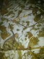
The spot
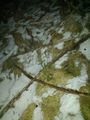
X..
..K..
..CD!
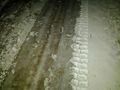
The road was pure ice!
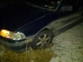
Car
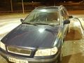
Home again

Tired Ultra hasher


Achievements
Carl-Johan earned the Land geohash achievement
|
Carl-Johan earned the Frozen Geohash Achievement
|
Carl-Johan achieved level 4 of the Minesweeper Geohash achievement
|
Carl-Johan earned the Multihash Achievement
|
Carl-Johan earned the Police Geohash Achievement
|