Difference between revisions of "2014-02-27 49 8"
imported>DODO (→Participants) |
|||
| (17 intermediate revisions by 3 users not shown) | |||
| Line 1: | Line 1: | ||
| − | |||
| − | |||
| − | |||
| − | |||
| − | |||
| − | |||
| − | |||
| − | |||
| − | |||
| − | |||
{{meetup graticule | {{meetup graticule | ||
| lat=49 | | lat=49 | ||
| Line 15: | Line 5: | ||
}} | }} | ||
| − | |||
__NOTOC__ | __NOTOC__ | ||
== Location == | == Location == | ||
| − | + | ||
| − | + | At the edge of an asparagus field between Grenzhof and Plankstadt. | |
| + | |||
| + | Country: Germany; state: Baden-Württemberg (EU:DE:BW); administrative region: Karlsruhe; district: Heidelberg | ||
| + | |||
== Participants == | == Participants == | ||
| − | |||
| − | |||
[[User:DODO|DODO]] | [[User:DODO|DODO]] | ||
| + | |||
| + | [[User:Danatar|Danatar]] | ||
| + | |||
== Plans == | == Plans == | ||
| − | + | ||
| + | [[User:DODO|DODO]]: To close to work to not going. Will probably go there on my way to work and arrive around 8. On the other hand my experience from last [[2014-02-23 49 8|sunday]] had been to good to not trying to meet other geohashers. So if anyone would be able to come around 5 in the afternoon (and announce that before tomorrow morning) I could come along on my way home. | ||
| + | |||
| + | [[User:Danatar|Danatar]]: Depending in my other tasks, 5pm might be possible for me, too. | ||
| + | :I'll arrive at the hashpoint around 16:45. [[User:DODO|DODO]] | ||
| + | |||
== Expedition == | == Expedition == | ||
| − | + | ===DODO=== | |
| + | [[2014-02-23_49_8|previous]] [[2014-03-15 49 8|next]] | ||
| − | + | Not much to add to Danatars log. A short and uneventful ride near the hash, but I had to walk the last 800m because I had to cross a railroad and my [http://www.greenmover.de/product/e45-herren/ bull] hates stairs. After some fotos and some talking we both left again. On my way home I saw some remarkable birds (a flying buzzard, a grey heron next to the road and a pheasant) but couldn't take a picture of any of them. I cycled 26 KM exceeding my usually way home by 10 KM. Left an x in the ground and a small egg in its center. | |
| − | |||
| − | |||
<!-- Insert pictures between the gallery tags using the following format: | <!-- Insert pictures between the gallery tags using the following format: | ||
Image:2012-##-## ## ## Alpha.jpg | Witty Comment | Image:2012-##-## ## ## Alpha.jpg | Witty Comment | ||
--> | --> | ||
<gallery perrow="5"> | <gallery perrow="5"> | ||
| + | Image: 2014-02-27 49 8-1.jpg | Danatar and his bike | ||
| + | Image: 2014-02-27 49 8-2.jpg | Little DODO left a little egg | ||
| + | Image: 2014-02-27_49_8.jpg | Stupid grin (or something like that) | ||
</gallery> | </gallery> | ||
| + | |||
| + | ===Danatar=== | ||
| + | From my parents' place it was a nice distance to cycle to the hashpoint. When I was preparing to start, I saw DODO's message that he would be there around 16:45, so I started instantly. Since I was planning for a tron route, I crossed the bridge to Neckarhausen, then made a detour via Edingen and Grenzhof. The roads were good and there wasn't much traffic. At 16:43 I arrived near the hashpoint, coming from the south. While I was taking pictures I saw DODO arriving from the north. We then proceeded to the exact location, which was about 3 m from the place where I had stopped. Our GPS receivers sent us to different spots with 3 rows of asparagus in between. Since both of us had plans for the evening, we didn't stay long. Still aiming for the tron achievement, I continued north from the hashpoint. After walking along a small dirt track for a while I reached the road that went on to Friedrichsfeld. From there I cycled via Seckenheim and Ilvesheim back to Ladenburg. | ||
| + | |||
| + | I cycled 19.5 km. Except for the last 3 meters to the hashpoint (and the GPS errors there) and the driveway of my parents' house, my route didn't cross itself, so it's another (the sixth) tron achievement for me. | ||
| + | |||
| + | |||
| + | <gallery> | ||
| + | File:2014-02-27_49_8_da_grenzhof.jpg|Grenzhof hamlet | ||
| + | File:2014-02-27_49_8_da_near.jpg|almost there | ||
| + | File:2014-02-27_49_8_da_dodoarriving.jpg|DODO arriving | ||
| + | File:2014-02-27_49_8_da_gps.jpg|GPS at Danatar's location | ||
| + | File:2014-02-27_49_8_da_andererhp.jpg|location for DODO | ||
| + | File:2014-02-27_49_8_da_pano.jpg|panorama | ||
| + | File:2014-02-27_49_8_da_hp.jpg|coordinates reached, new geohasher met! | ||
| + | File:2014-02-27_49_8_da_gaense.jpg|geese near the dam near Ladenburg | ||
| + | File:2014-02-27_49_8_da_tron.jpg|tron route | ||
| + | </gallery> | ||
| + | |||
| + | [http://www.everytrail.com/view_trip.php?trip_id=2683817&code=1bc79738b8cc717e21dae402f82af3f6 Danatar's triton tracklog] | ||
| + | |||
== Achievements == | == Achievements == | ||
| Line 46: | Line 67: | ||
<!-- Add any achievement ribbons you earned below, or remove this section --> | <!-- Add any achievement ribbons you earned below, or remove this section --> | ||
| + | {{land geohash | ||
| − | + | | latitude = 49 | |
| − | + | | longitude = 8 | |
| − | + | | date = 2014-02-27 | |
| + | | name = DODO | ||
| + | }} | ||
| − | + | {{Meet-up | |
| + | | latitude = 49 | ||
| + | | longitude = 8 | ||
| + | | date = 2014-02-27 | ||
| + | | name = [[User:Danatar|Danatar]] and [[User:DODO|DODO]] | ||
| + | | other = eachother | ||
| + | }} | ||
| − | + | {{Tron | |
| − | + | | latitude = 49 | |
| − | + | | longitude = 8 | |
| − | -- | + | | date = 2014-02-27 |
| + | | name = Danatar | ||
| + | | tracklog = http://www.everytrail.com/view_trip.php?trip_id=2683817&code=1bc79738b8cc717e21dae402f82af3f6 | ||
| + | | possessive = his | ||
| + | | image = 2014-02-27_49_8_da_tron.jpg | ||
| + | }} | ||
| − | |||
[[Category:Expeditions]] | [[Category:Expeditions]] | ||
| − | + | [[Category:Expeditions with photos]] | |
| − | [[Category:Expeditions with photos]] | ||
| − | |||
| − | |||
| − | |||
| − | |||
| − | |||
[[Category:Coordinates reached]] | [[Category:Coordinates reached]] | ||
| − | + | [[Category:Danatar]] | |
| − | + | {{location|DE|BW|HD|city=true}} | |
| − | |||
| − | [[Category: | ||
| − | |||
| − | |||
| − | |||
| − | |||
| − | |||
| − | |||
| − | |||
| − | |||
| − | |||
| − | |||
| − | |||
| − | |||
| − | |||
| − | |||
Latest revision as of 16:25, 23 April 2020
| Thu 27 Feb 2014 in 49,8: 49.4130949, 8.5791287 geohashing.info google osm bing/os kml crox |
Location
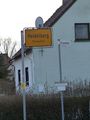
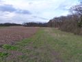
At the edge of an asparagus field between Grenzhof and Plankstadt.
Country: Germany; state: Baden-Württemberg (EU:DE:BW); administrative region: Karlsruhe; district: Heidelberg
Participants
Plans
DODO: To close to work to not going. Will probably go there on my way to work and arrive around 8. On the other hand my experience from last sunday had been to good to not trying to meet other geohashers. So if anyone would be able to come around 5 in the afternoon (and announce that before tomorrow morning) I could come along on my way home.
Danatar: Depending in my other tasks, 5pm might be possible for me, too.
- I'll arrive at the hashpoint around 16:45. DODO
Expedition
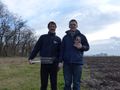
DODO
Not much to add to Danatars log. A short and uneventful ride near the hash, but I had to walk the last 800m because I had to cross a railroad and my bull hates stairs. After some fotos and some talking we both left again. On my way home I saw some remarkable birds (a flying buzzard, a grey heron next to the road and a pheasant) but couldn't take a picture of any of them. I cycled 26 KM exceeding my usually way home by 10 KM. Left an x in the ground and a small egg in its center.
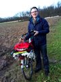
Danatar and his bike
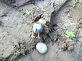
Little DODO left a little egg

Stupid grin (or something like that)


Danatar
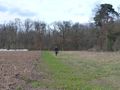
From my parents' place it was a nice distance to cycle to the hashpoint. When I was preparing to start, I saw DODO's message that he would be there around 16:45, so I started instantly. Since I was planning for a tron route, I crossed the bridge to Neckarhausen, then made a detour via Edingen and Grenzhof. The roads were good and there wasn't much traffic. At 16:43 I arrived near the hashpoint, coming from the south. While I was taking pictures I saw DODO arriving from the north. We then proceeded to the exact location, which was about 3 m from the place where I had stopped. Our GPS receivers sent us to different spots with 3 rows of asparagus in between. Since both of us had plans for the evening, we didn't stay long. Still aiming for the tron achievement, I continued north from the hashpoint. After walking along a small dirt track for a while I reached the road that went on to Friedrichsfeld. From there I cycled via Seckenheim and Ilvesheim back to Ladenburg.
I cycled 19.5 km. Except for the last 3 meters to the hashpoint (and the GPS errors there) and the driveway of my parents' house, my route didn't cross itself, so it's another (the sixth) tron achievement for me.
Grenzhof hamlet
almost there
DODO arriving
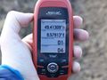
GPS at Danatar's location
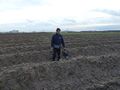
location for DODO
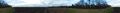
panorama
coordinates reached, new geohasher met!
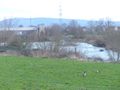
geese near the dam near Ladenburg
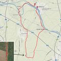
tron route


Achievements
DODO earned the Land geohash achievement
|
Danatar and DODO earned the Meet-up achievement
|
Danatar earned the Tron achievement
|