Difference between revisions of "2020-05-06 55 13"
m (Location) |
m (Update graticule name/link) |
||
| (One intermediate revision by the same user not shown) | |||
| Line 1: | Line 1: | ||
| − | + | {{meetup graticule | |
| − | |||
| − | |||
| − | |||
| − | |||
| − | |||
| − | |||
| − | |||
| − | |||
| lat=55 | | lat=55 | ||
| lon=13 | | lon=13 | ||
| date=2020-05-06 | | date=2020-05-06 | ||
| − | }} | + | | graticule_name=Eslöv |
| + | | graticule_link=Malmö, Sweden | ||
| + | }} | ||
__NOTOC__ | __NOTOC__ | ||
== Location == | == Location == | ||
| − | |||
This Geohash is located in a field outside Eslöv | This Geohash is located in a field outside Eslöv | ||
| Line 25: | Line 18: | ||
== Expedition == | == Expedition == | ||
| − | + | We left by car as planned. I tried navigating GPS-less fairly unsuccessfully, but we got there in the end. We parked by a barn fairly close to the hash and it didn't take long until the land owner came around to see what we were doing. Apparently there had been someone gone missing so they were keeping a close watch on unknown cars, but it was fine for us to park there. We then took a short walk towards the field where the hash was located and as suspected there was no way of getting there without stepping on the crops so we took some pictures and left. | |
| − | |||
| − | |||
| − | |||
== Photos == | == Photos == | ||
| − | |||
| − | |||
| − | |||
<gallery perrow="5"> | <gallery perrow="5"> | ||
| + | File:20200506-IMG_20200506_180620.jpg | Field | ||
| + | File:20200506-IMG_20200506_180647.jpg | Selfie | ||
| + | File:20200507-Screenshot_20200506-180720.jpg | How close we got | ||
</gallery> | </gallery> | ||
| − | |||
| − | |||
| − | |||
| − | |||
| − | |||
| − | |||
| − | |||
| − | |||
| − | |||
[[Category:Expeditions]] | [[Category:Expeditions]] | ||
| − | |||
[[Category:Expeditions with photos]] | [[Category:Expeditions with photos]] | ||
| − | |||
| − | |||
| − | |||
| − | |||
| − | |||
| − | |||
| − | |||
| − | |||
| − | |||
[[Category:Coordinates not reached]] | [[Category:Coordinates not reached]] | ||
| − | |||
| − | |||
| − | |||
| − | |||
| − | |||
[[Category:Not reached - No public access]] | [[Category:Not reached - No public access]] | ||
| − | |||
| − | |||
| − | |||
| − | |||
| − | |||
| − | |||
| − | |||
| − | |||
{{location|SE|M}} | {{location|SE|M}} | ||
Latest revision as of 19:22, 7 May 2020
| Wed 6 May 2020 in Eslöv: 55.8131507, 13.2781183 geohashing.info google osm bing/os kml crox |
Location
This Geohash is located in a field outside Eslöv
Participants
gnuX Emeli
Plans
We're going by car from Malmö ~17:00. It's unlikely we'll be able to reach the exact hash without stepping on some crops, but we can try to get as close as possible.
Expedition
We left by car as planned. I tried navigating GPS-less fairly unsuccessfully, but we got there in the end. We parked by a barn fairly close to the hash and it didn't take long until the land owner came around to see what we were doing. Apparently there had been someone gone missing so they were keeping a close watch on unknown cars, but it was fine for us to park there. We then took a short walk towards the field where the hash was located and as suspected there was no way of getting there without stepping on the crops so we took some pictures and left.
Photos
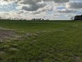
Field

Selfie
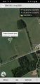
How close we got


