Difference between revisions of "2016-01-10 48 11"
imported>Tads (Created page with "{{subst:Expedition |lat = 48 |lon = 11 |date = 2016-01-10 }} Category: Meetup on 2016-01-10 Category: Meetup in 48 11") |
m (Location correction) |
||
| (2 intermediate revisions by 2 users not shown) | |||
| Line 1: | Line 1: | ||
| − | |||
| − | |||
| − | |||
| − | |||
| − | |||
| − | |||
| − | |||
| − | |||
| − | |||
| − | |||
{{meetup graticule | {{meetup graticule | ||
| lat=48 | | lat=48 | ||
| Line 19: | Line 9: | ||
== Location == | == Location == | ||
| − | + | In a wood (part of Forstenrieder Park) at the southern border of Munich. | |
== Participants == | == Participants == | ||
| − | + | * [[User:tads|tads]] | |
| − | |||
== Plans == | == Plans == | ||
| − | + | Go out for a sunday walk and find the hashpoint. | |
== Expedition == | == Expedition == | ||
| − | + | I started my walk at Forstenrieder Allee, Munich towards the hashpoint. After about half an hour walk through residential area, a small disc golf course and fields, I reached the forest, so the hashpoint could not be far. However, I was stopped close before reaching it. At a distance of 18m to the location, I was stopped by a fence and a warning sign telling me Danger, No Trespassing. Oh, bad luck! Afterwards, I found out on the map that the area probably belongs to a closeby Schützenverein (marksmen club). I thus continued my walk, went to Großhesselohe, Munich and then went on via the S-Bahn. | |
| − | |||
| − | |||
| − | |||
== Photos == | == Photos == | ||
| − | |||
| − | |||
| − | |||
<gallery perrow="5"> | <gallery perrow="5"> | ||
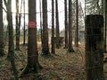
| + | Image:tads_2016-01-10_48_11_dangersign.jpg | View towards the hashpoint. Danger sign and fence. | ||
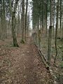
| + | Image:tads_2016-01-10_48_11_fence-east.jpg | View to the east. | ||
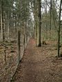
| + | Image:tads_2016-01-10_48_11_fence-west.jpg | View to the west. | ||
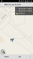
| + | Image:tads_2016-01-10_48_11_proof.png | Close but not close enough. | ||
</gallery> | </gallery> | ||
== Achievements == | == Achievements == | ||
{{#vardefine:ribbonwidth|800px}} | {{#vardefine:ribbonwidth|800px}} | ||
| − | + | {{No trespassing | |
| − | + | | latitude = 48 | |
| − | + | | longitude = 11 | |
| − | + | | date = 2016-01-10 | |
| − | [[ | + | | name = [[User:Tads|Tads]] ([[User talk:Tads|talk]]) |
| − | + | | distance = 18m | |
| − | + | }} | |
| − | |||
| − | [[ | ||
| − | |||
| − | |||
| − | |||
[[Category:Expeditions]] | [[Category:Expeditions]] | ||
| − | |||
[[Category:Expeditions with photos]] | [[Category:Expeditions with photos]] | ||
| − | |||
| − | |||
| − | |||
| − | |||
| − | |||
| − | |||
| − | |||
| − | |||
| − | |||
[[Category:Coordinates not reached]] | [[Category:Coordinates not reached]] | ||
| − | |||
| − | |||
| − | |||
| − | |||
| − | |||
[[Category:Not reached - No public access]] | [[Category:Not reached - No public access]] | ||
| − | |||
| − | |||
| − | |||
| − | |||
| − | |||
| − | |||
| − | |||
| − | |||
| − | |||
[[Category: Meetup on 2016-01-10]] | [[Category: Meetup on 2016-01-10]] | ||
[[Category: Meetup in 48 11]] | [[Category: Meetup in 48 11]] | ||
| + | {{location|DE|BY|M}} | ||
Latest revision as of 20:31, 16 May 2020
| Sun 10 Jan 2016 in 48,11: 48.0730156, 11.4946231 geohashing.info google osm bing/os kml crox |
Location
In a wood (part of Forstenrieder Park) at the southern border of Munich.
Participants
Plans
Go out for a sunday walk and find the hashpoint.
Expedition
I started my walk at Forstenrieder Allee, Munich towards the hashpoint. After about half an hour walk through residential area, a small disc golf course and fields, I reached the forest, so the hashpoint could not be far. However, I was stopped close before reaching it. At a distance of 18m to the location, I was stopped by a fence and a warning sign telling me Danger, No Trespassing. Oh, bad luck! Afterwards, I found out on the map that the area probably belongs to a closeby Schützenverein (marksmen club). I thus continued my walk, went to Großhesselohe, Munich and then went on via the S-Bahn.
Photos
View towards the hashpoint. Danger sign and fence.
View to the east.
View to the west.
Close but not close enough.


Achievements
Tads (talk) earned the No trespassing consolation prize
|