Difference between revisions of "2010-01-19 -37 145"
(Created page with '{{subst:Expedition |lat = -37 |lon = 145 |date = 2010-01-19 }}') |
m (More specific location) |
||
| (6 intermediate revisions by 3 users not shown) | |||
| Line 1: | Line 1: | ||
| − | |||
<!-- If you did not specify these parameters in the template, please substitute appropriate things for IMAGE, LAT, LON, and DATE (YYYY-MM-DD format) | <!-- If you did not specify these parameters in the template, please substitute appropriate things for IMAGE, LAT, LON, and DATE (YYYY-MM-DD format) | ||
| Line 15: | Line 14: | ||
__NOTOC__ | __NOTOC__ | ||
== Location == | == Location == | ||
| − | + | In the middle of what appeared to be a reserve close to the Eastlink Freeway in Glen Waverley / Wantirna South. | |
== Participants == | == Participants == | ||
| − | + | [[User:Kozz|Kozz]] | |
== Plans == | == Plans == | ||
| − | + | Initially - head out on the bike first thing in the morning. | |
| + | Actuality - by car and foot. | ||
== Expedition == | == Expedition == | ||
| + | [[user:Kozz|Kozz]]: This wasn't too far away from home, and I'd initially hoped to do an early morning cycle geohash, but a combo of overnight rain and a migraine kept me in bed till the late morning. I decided to bundle a geohash attempt with a trip to the chemist to find painkillers, theorising it wouldn't take too long. | ||
| + | Slotted the coords into the satnav and followed its instructions; it presented the hash as in the middle of an area marked as a reserve - exactly the same as marked on Google Maps. The Google Maps satellite view was quite dated (still showing construction of the nearby Eastlink highway, which opened last year) so I theorised that the machines I could see in the satellite imagery must've been from the road crews. | ||
| − | + | The satnav got plain confused - it wanted me to drive the wrong direction up what looked like a highway offramp to get there, so I used dead reckoning to find another access point - with parks nearby, I surmised that this must just be another instance of massive open green parkland connected by paths. The decision to not follow the satnav's instructions would prove to be costly. | |
| + | I found a road leading to a marked path leading to the corner of the open green area, and took a quick walk along the path - it's part of the Dandenong Creek Trail, one of a myriad of creek trails in Melbourne. To the right was a fenced off area - which transpired to be a quarry - and to the left there were fields, and from somewhere nearby I could hear heavy machinery at work. As I continued on I pondered why the parkland was fenced off by a 9 foot chainlink fence topped with barbed wire, but pressed on as the path swung south then east again, vaguely towards the hashpoint. | ||
| − | + | About 1km in and still 350m from the hashpoint, I walked past a carpark next to a massive barn-like building. Stacked outside were about 30 mattresses, and...I realised I could smell the unmistakable stench of decaying garbage. Lots of it. | |
| − | + | The reason I could hear heavy machinery was because it was operating in a 'transfer station' - otherwise known as a town refuse dump, tip, or trash pile. Yes that's right - the hash for today in Melbourne East '''is in the middle of a MASSIVE HEAP OF TRASH'''. | |
| − | |||
| − | |||
| − | |||
| − | |||
| − | |||
| + | I toyed with the idea of doing the world's most comprehensive geotrash collection - I mean, c'mon, BONANZA - but gave up the idea pretty much immediately. Aside from the physical danger of trespassing on a massive, flat, open, dangerous ground patrolled by great big graders and tractors pushing trash around, who wants to be walking over piles of refuse? With medical waste poking through your shoes, used nappies clinging to your bare legs, breathing in the soupcon of fetid trash air? | ||
| − | + | I went back to the car somewhat disheartened, and drove around to the suggest satnav point which of course took me past the massive sign that said 'KNOX CITY TRANSFER STATION'. I stopped at a nearby gate - the closest I could get to the hash - and took a photo of the hashpoint, then with a heavy heart and a migraine returning, left once again. Failed to reach coordinates; no public access. And no thank you, I do not wish to become the recipient of the first ever 'failed to reach coordinates: health risk' award. | |
| − | |||
| − | < | + | == Photos == |
| − | + | <gallery perrow="4"> | |
| − | + | Image:2010-01-19 -37 145 Gravel-road.jpg | Woooo, gravel road | |
| − | --> | + | Image:2010-01-19 -37 145 bike-path.jpg | The bike path |
| + | Image:2010-01-19 -37 145 Cycle-trail.jpg | History / linkage of the cycle trail | ||
| + | Image:2010-01-19 -37 145 Blue-skies.jpg | Blue skies | ||
| + | Image:2010-01-19 -37 145 Heron.jpg | Heron keeping an eye out | ||
| + | Image:2010-01-19 -37 145 Quarry.jpg | It's a quarry | ||
| + | Image:2010-01-19 -37 145 Quarry-Warning.jpg | Quarry warning | ||
| + | Image:2010-01-19 -37 145 Chainlick-blockage.jpg | Blocked by chainlink, the geohasher's nemesis | ||
| + | Image:2010-01-19 -37 145 Distance-at-footpath.jpg | Close as I got on foot | ||
| + | Image:2010-01-19 -37 145 Hash-point.jpg | The hash point way in the distance | ||
| + | Image:2010-01-19 -37 145 Closest-point.jpg | This is as close as I got :o( | ||
| + | </gallery> | ||
| − | |||
[[Category:Expeditions]] | [[Category:Expeditions]] | ||
| − | |||
[[Category:Expeditions with photos]] | [[Category:Expeditions with photos]] | ||
| − | |||
| − | |||
| − | |||
| − | |||
| − | |||
| − | |||
| − | |||
| − | |||
| − | |||
[[Category:Coordinates not reached]] | [[Category:Coordinates not reached]] | ||
| − | |||
| − | |||
[[Category:Not reached - No public access]] | [[Category:Not reached - No public access]] | ||
| − | + | {{location|AU|VIC|KN}} | |
| − | |||
| − | |||
Latest revision as of 11:55, 1 August 2020
| Tue 19 Jan 2010 in -37,145: -37.8807697, 145.2097187 geohashing.info google osm bing/os kml crox |
Location
In the middle of what appeared to be a reserve close to the Eastlink Freeway in Glen Waverley / Wantirna South.
Participants
Plans
Initially - head out on the bike first thing in the morning. Actuality - by car and foot.
Expedition
Kozz: This wasn't too far away from home, and I'd initially hoped to do an early morning cycle geohash, but a combo of overnight rain and a migraine kept me in bed till the late morning. I decided to bundle a geohash attempt with a trip to the chemist to find painkillers, theorising it wouldn't take too long.
Slotted the coords into the satnav and followed its instructions; it presented the hash as in the middle of an area marked as a reserve - exactly the same as marked on Google Maps. The Google Maps satellite view was quite dated (still showing construction of the nearby Eastlink highway, which opened last year) so I theorised that the machines I could see in the satellite imagery must've been from the road crews.
The satnav got plain confused - it wanted me to drive the wrong direction up what looked like a highway offramp to get there, so I used dead reckoning to find another access point - with parks nearby, I surmised that this must just be another instance of massive open green parkland connected by paths. The decision to not follow the satnav's instructions would prove to be costly.
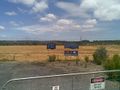
I found a road leading to a marked path leading to the corner of the open green area, and took a quick walk along the path - it's part of the Dandenong Creek Trail, one of a myriad of creek trails in Melbourne. To the right was a fenced off area - which transpired to be a quarry - and to the left there were fields, and from somewhere nearby I could hear heavy machinery at work. As I continued on I pondered why the parkland was fenced off by a 9 foot chainlink fence topped with barbed wire, but pressed on as the path swung south then east again, vaguely towards the hashpoint.
About 1km in and still 350m from the hashpoint, I walked past a carpark next to a massive barn-like building. Stacked outside were about 30 mattresses, and...I realised I could smell the unmistakable stench of decaying garbage. Lots of it.
The reason I could hear heavy machinery was because it was operating in a 'transfer station' - otherwise known as a town refuse dump, tip, or trash pile. Yes that's right - the hash for today in Melbourne East is in the middle of a MASSIVE HEAP OF TRASH.
I toyed with the idea of doing the world's most comprehensive geotrash collection - I mean, c'mon, BONANZA - but gave up the idea pretty much immediately. Aside from the physical danger of trespassing on a massive, flat, open, dangerous ground patrolled by great big graders and tractors pushing trash around, who wants to be walking over piles of refuse? With medical waste poking through your shoes, used nappies clinging to your bare legs, breathing in the soupcon of fetid trash air?
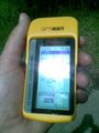
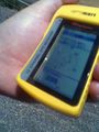
I went back to the car somewhat disheartened, and drove around to the suggest satnav point which of course took me past the massive sign that said 'KNOX CITY TRANSFER STATION'. I stopped at a nearby gate - the closest I could get to the hash - and took a photo of the hashpoint, then with a heavy heart and a migraine returning, left once again. Failed to reach coordinates; no public access. And no thank you, I do not wish to become the recipient of the first ever 'failed to reach coordinates: health risk' award.
Photos
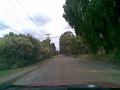
Woooo, gravel road
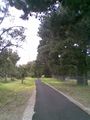
The bike path
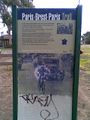
History / linkage of the cycle trail
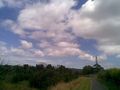
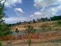
Blue skies
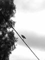
Heron keeping an eye out
It's a quarry
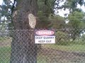
Quarry warning
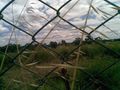
Blocked by chainlink, the geohasher's nemesis
Close as I got on foot
The hash point way in the distance
This is as close as I got :o(


