Difference between revisions of "2010-03-25 -37 145"
From Geohashing
imported>Kozz (Created page with '{{subst:Expedition |lat = -37 |lon = 145 |date = 2010-03-25 }}') |
m (More specific location) |
||
| (2 intermediate revisions by 2 users not shown) | |||
| Line 1: | Line 1: | ||
| − | |||
| − | |||
| − | |||
| − | |||
| − | |||
| − | |||
| − | |||
{{meetup graticule | {{meetup graticule | ||
| lat=-37 | | lat=-37 | ||
| Line 15: | Line 8: | ||
__NOTOC__ | __NOTOC__ | ||
== Location == | == Location == | ||
| − | + | Someone's back yard in Bulleen | |
| − | |||
== Participants == | == Participants == | ||
| − | + | [[user:Kozz|Kozz]] | |
== Plans == | == Plans == | ||
| − | + | Drive there after work | |
== Expedition == | == Expedition == | ||
| − | + | I drove to the hashpoint after work, could easily see where it was - behind a house and a fence. | |
| + | |||
| + | There was an old dude taking out his recycling next to the driveway into the hashpoint. I said hello, he looked at me blankly, I really couldn't be bothered asking him to unlock his back yard so I could take the photo at the point itself and kept on walking. | ||
| − | + | So, fail, private property - I got within 10 metres but there was accuracy of under 5 so I was still quite a bit off. | |
| − | |||
== Photos == | == Photos == | ||
| − | |||
| − | |||
| − | |||
<gallery perrow="4"> | <gallery perrow="4"> | ||
| + | Image:2010-03-25--37-145-On-the-r.jpg| Getting close | ||
| + | Image:2010-03-25--37-145-Houser.jpg| The hoose in question | ||
| + | Image:2010-03-25--37-145-Closest.jpg | Closest I gots | ||
</gallery> | </gallery> | ||
| − | |||
| − | |||
| − | |||
| − | |||
| − | |||
| − | |||
| − | |||
| − | |||
| − | |||
| − | |||
[[Category:Expeditions]] | [[Category:Expeditions]] | ||
| − | |||
[[Category:Expeditions with photos]] | [[Category:Expeditions with photos]] | ||
| − | |||
| − | |||
| − | |||
| − | |||
| − | |||
| − | |||
| − | |||
| − | |||
| − | |||
[[Category:Coordinates not reached]] | [[Category:Coordinates not reached]] | ||
| − | |||
| − | |||
[[Category:Not reached - No public access]] | [[Category:Not reached - No public access]] | ||
| − | + | {{location|AU|VIC|MN}} | |
| − | |||
| − | |||
Latest revision as of 11:59, 1 August 2020
| Thu 25 Mar 2010 in -37,145: -37.7678183, 145.1027620 geohashing.info google osm bing/os kml crox |
Location
Someone's back yard in Bulleen
Participants
Plans
Drive there after work
Expedition
I drove to the hashpoint after work, could easily see where it was - behind a house and a fence.
There was an old dude taking out his recycling next to the driveway into the hashpoint. I said hello, he looked at me blankly, I really couldn't be bothered asking him to unlock his back yard so I could take the photo at the point itself and kept on walking.
So, fail, private property - I got within 10 metres but there was accuracy of under 5 so I was still quite a bit off.
Photos
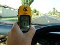
Getting close
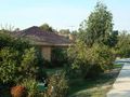
The hoose in question
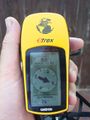
Closest I gots


