Difference between revisions of "2012-07-19 -37 143"
From Geohashing
imported>Snaplatitude |
m (More specific location) |
||
| (4 intermediate revisions by 3 users not shown) | |||
| Line 1: | Line 1: | ||
| − | |||
| − | |||
| − | |||
| − | |||
| − | |||
| − | |||
| − | |||
| − | |||
| − | |||
{{meetup graticule | {{meetup graticule | ||
| lat=-37 | | lat=-37 | ||
| Line 14: | Line 5: | ||
}} | }} | ||
| − | + | ||
__NOTOC__ | __NOTOC__ | ||
== Location == | == Location == | ||
| Line 20: | Line 11: | ||
== Participants == | == Participants == | ||
| − | [[User:Snaplatitude|Snaplatitude]] | + | * [[User:Snaplatitude|Snaplatitude]] |
== Expedition == | == Expedition == | ||
| Line 35: | Line 26: | ||
| − | + | [[Category:Expeditions]] | |
| − | |||
| − | [[Category: | ||
| − | |||
| − | |||
| − | |||
| − | |||
| − | |||
| − | |||
| − | |||
| − | |||
[[Category:Expeditions with photos]] | [[Category:Expeditions with photos]] | ||
| − | |||
| − | |||
| − | |||
| − | |||
| − | |||
| − | |||
| − | |||
| − | |||
| − | |||
[[Category:Coordinates not reached]] | [[Category:Coordinates not reached]] | ||
| − | |||
| − | |||
| − | |||
| − | |||
| − | |||
[[Category:Not reached - No public access]] | [[Category:Not reached - No public access]] | ||
| − | + | {{location|AU|VIC|GP}} | |
| − | |||
| − | |||
| − | |||
| − | |||
| − | |||
| − | |||
| − | |||
Latest revision as of 12:19, 1 August 2020
| Thu 19 Jul 2012 in -37,143: -37.5753560, 143.6911301 geohashing.info google osm bing/os kml crox |
Location
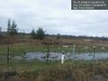
In a private paddock just out of Haddon, Vic.
Participants
Expedition
Not a lot to say. yet another failed hash due to private property. perhaps if i hashed in a different graticule?
Photos
Private property @-37.5739,143.6833
