Difference between revisions of "2016-04-09 -37 145"
imported>Kozz (→Location) |
m (More specific location) |
||
| (16 intermediate revisions by 3 users not shown) | |||
| Line 2: | Line 2: | ||
<!-- If you did not specify these parameters in the template, please substitute appropriate values for IMAGE, LAT, LON, and DATE (YYYY-MM-DD format) | <!-- If you did not specify these parameters in the template, please substitute appropriate values for IMAGE, LAT, LON, and DATE (YYYY-MM-DD format) | ||
| − | [[Image:{{{image| | + | [[Image:{{{image|2016-04-09_-37_145_kozz_1460152014905.jpg}}}|thumb|left]] |
Remove this section if you don't want an image at the top (left) of your report. You should remove the "Image:" or "File:" | Remove this section if you don't want an image at the top (left) of your report. You should remove the "Image:" or "File:" | ||
| Line 19: | Line 19: | ||
== Location == | == Location == | ||
| − | + | A farm (private property) in the undulating hills at the back of Diamond Creek, Melbourne. | |
| + | |||
| + | [[User:Kozz|Kozz]] | ||
== Participants == | == Participants == | ||
| − | + | [[User:Kozz|Kozz]] | |
| − | |||
== Plans == | == Plans == | ||
| − | + | 5am start, cycle out up through Eltham then Diamond Creek to Ironbark Road then Murray Road - 2 possible entrances, preferably the second (looks like a gravel road) | |
== Expedition == | == Expedition == | ||
| − | + | Yeah bitches, Melbourne East is back on the map! Why did it drop off the map? Because [[User:Felix_Dance|Felix Dance]] flew north for the winter. Slack. | |
| + | |||
| + | So yeah, it's been a while. Since the last time I officially geohashed (yes, there have been unofficial geohashes) there's been another Kozz joined the family and a personal transition from Jabba-esque proportions to Obi-Wan-esque proportions. | ||
| + | |||
| + | The 2016 model of Kozz is the [https://en.wikipedia.org/wiki/Mamil MAMIL] variant, hence looking for opportunities to cycle places. This looked ok, I knew the route out to Diamond Creek, so thought hell why not let's crank on out there. | ||
| + | |||
| + | All was well and good till the turnoff onto the access road which quickly became gravel which became coarse road metal which became steep hills. Great news on a road bike and 23c tyres. Not wanting a puncture I took it very easily and was promptly accosted by an elderly woman with a small dog inquiring as to my intentions on this quiet little side street. 'Internet scavenger hunt' fit the bill this time. | ||
| + | |||
| + | I actually went past the spot on an ascent, focussing on not falling off the bike. It's on a steep slope, off the road on private property. It wasn't worth the schlep to the hash point so snapped a picture and some positional stuff and off we go. On the way home there was a glorious albeit short-lived sunrise - painted the hills with dull golden autumn sunlight, etc etc. | ||
| + | |||
| + | If any other Melbournians are heading out this way there's 7-11 just out of Diamond Creek, go for the old slushie achievement. | ||
| + | |||
| + | PS. For those who remember my erstwhile companion on previous hashes. I'm sorry to say Kozz's Dog passed away a while ago, poor bugger. I had a kick of nostalgia working through all the photos and stuff up on the wiki - great news that he will live on in this wiki through his achievements. [[User:Kozz|Kozz]] ([[User talk:Kozz|talk]]) 22:27, 8 April 2016 (UTC) | ||
== Tracklog == | == Tracklog == | ||
| − | + | ||
== Photos == | == Photos == | ||
| − | |||
| − | |||
| − | |||
<gallery perrow="5"> | <gallery perrow="5"> | ||
| + | Image: 2016-04-09_-37_145_kozz_1460152014905.jpg | The hashpoint | ||
| + | Image: 2016-04-09_-37_145_kozz_1460165917368.jpg | Murray Road: Steep hills and gravel. Perfect for a road bike with thin tires. | ||
| + | Image: 2016-04-09_-37_145_kozz_1460165877513.jpg | Sunrise | ||
| + | Image: 2016-04-09_-37_145_kozz_1460166151368.jpg | View from Ironbark Road | ||
</gallery> | </gallery> | ||
== Achievements == | == Achievements == | ||
| − | {{ | + | {{bicycle geohash |
| − | + | | latitude = -37 | |
| + | | longitude = 145 | ||
| + | | date = 2016-04-09 | ||
| + | | name = [[User:Kozz|Kozz]] | ||
| + | | distance = 52km | ||
| + | | bothways = true | ||
| + | }} | ||
| − | + | {{No trespassing | |
| − | + | | latitude = -37 | |
| − | + | | longitude = 145 | |
| − | + | | date = 2016-04-09 | |
| − | + | | name = [[User:Kozz|Kozz]] | |
| − | + | }} | |
| − | [[ | ||
| − | |||
| − | |||
| − | |||
| − | |||
[[Category:Expeditions]] | [[Category:Expeditions]] | ||
| − | |||
[[Category:Expeditions with photos]] | [[Category:Expeditions with photos]] | ||
| − | |||
[[Category:Expedition without GPS]] | [[Category:Expedition without GPS]] | ||
| − | |||
| − | |||
| − | |||
| − | |||
| − | |||
| − | |||
| − | |||
[[Category:Coordinates not reached]] | [[Category:Coordinates not reached]] | ||
| − | |||
| − | |||
| − | |||
| − | |||
| − | |||
[[Category:Not reached - No public access]] | [[Category:Not reached - No public access]] | ||
| − | + | {{location|AU|VIC|NI}} | |
| − | |||
| − | |||
| − | |||
| − | |||
| − | |||
| − | |||
| − | |||
Latest revision as of 12:48, 1 August 2020
| Sat 9 Apr 2016 in -37,145: -37.6579399, 145.1496916 geohashing.info google osm bing/os kml crox |
Location
A farm (private property) in the undulating hills at the back of Diamond Creek, Melbourne.
Participants
Plans
5am start, cycle out up through Eltham then Diamond Creek to Ironbark Road then Murray Road - 2 possible entrances, preferably the second (looks like a gravel road)
Expedition
Yeah bitches, Melbourne East is back on the map! Why did it drop off the map? Because Felix Dance flew north for the winter. Slack.
So yeah, it's been a while. Since the last time I officially geohashed (yes, there have been unofficial geohashes) there's been another Kozz joined the family and a personal transition from Jabba-esque proportions to Obi-Wan-esque proportions.
The 2016 model of Kozz is the MAMIL variant, hence looking for opportunities to cycle places. This looked ok, I knew the route out to Diamond Creek, so thought hell why not let's crank on out there.
All was well and good till the turnoff onto the access road which quickly became gravel which became coarse road metal which became steep hills. Great news on a road bike and 23c tyres. Not wanting a puncture I took it very easily and was promptly accosted by an elderly woman with a small dog inquiring as to my intentions on this quiet little side street. 'Internet scavenger hunt' fit the bill this time.
I actually went past the spot on an ascent, focussing on not falling off the bike. It's on a steep slope, off the road on private property. It wasn't worth the schlep to the hash point so snapped a picture and some positional stuff and off we go. On the way home there was a glorious albeit short-lived sunrise - painted the hills with dull golden autumn sunlight, etc etc.
If any other Melbournians are heading out this way there's 7-11 just out of Diamond Creek, go for the old slushie achievement.
PS. For those who remember my erstwhile companion on previous hashes. I'm sorry to say Kozz's Dog passed away a while ago, poor bugger. I had a kick of nostalgia working through all the photos and stuff up on the wiki - great news that he will live on in this wiki through his achievements. Kozz (talk) 22:27, 8 April 2016 (UTC)
Tracklog
Photos
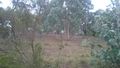
The hashpoint
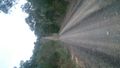
Murray Road: Steep hills and gravel. Perfect for a road bike with thin tires.
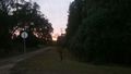
Sunrise
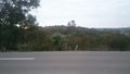
View from Ironbark Road


Achievements
Kozz earned the Bicycle geohash achievement
|
Kozz earned the No trespassing consolation prize
|