Difference between revisions of "2018-09-14 -37 145"
imported>Felix Dance ([live picture]Google Street view of the gate - I forget to take a photo myself) |
m (More specific location) |
||
| (3 intermediate revisions by 2 users not shown) | |||
| Line 1: | Line 1: | ||
| − | |||
| − | |||
| − | |||
| − | |||
| − | |||
| − | |||
| − | |||
| − | |||
| − | |||
| − | |||
{{meetup graticule | {{meetup graticule | ||
| lat=-37 | | lat=-37 | ||
| Line 14: | Line 4: | ||
| date=2018-09-14 | | date=2018-09-14 | ||
}} | }} | ||
| − | |||
| − | |||
| − | |||
== Location == | == Location == | ||
| − | + | In an industrial compound in Vermont | |
== Participants == | == Participants == | ||
| − | + | *[[User:Felix Dance|Felix Dance]] | |
| − | + | ||
| + | == Expedition == | ||
| + | When I checked the hashes in the morning I saw this one - it was going to be a beautiful, sunny day (the first for a while, coming out of Melbourne Winter), so I thought 'Great - let's do it!'. I left home on my road bike shortly after getting up, and headed along the interconnected bike paths of urban Melbourne. | ||
| + | |||
| + | When I got far enough out to feel a break was acceptable, I had a coffee at a golf course. It wasn't too long before I reached the hash-area, and immediately came across a problem. From the Google Satellite view, I didn't notice there was a heavy gate blocking access to the hash location, which was in the car park of this industrial estate. | ||
| + | |||
| + | When I got closer I noticed that the gate wasn't actually locked, and that I could actually just push it open and sneak in. However, big signs told me any visitors had to talk to the intercom to gain entry. I decided to be legit and do that. | ||
| + | |||
| + | "Hello, I'm here to collect a geohash?", I asked. | ||
| − | + | "What was that, mate?" Came the [https://en.wikipedia.org/wiki/Ocker Ocker] reply. | |
| − | |||
| − | + | "A geohash? I just need to get inside for 5 minutes". | |
| − | + | ||
| + | "What is that? I've never heard of whatever that is". Shit. So much for bluffing my way in. | ||
| + | |||
| + | "It's like an internet scavenger hunt. There's a location in your car park I need to get to". | ||
| + | |||
| + | "What's that? I'm not letting you in for some game. This is private property!" | ||
| + | |||
| + | "That's alright. That's why I asked. Thanks anyway!". | ||
| + | |||
| + | Well, that was that then. No success. I got back on my bike and rode off. Later I realised I should have taken a photo of the closest approach, but I've got a Google Streetview screenshot instead. | ||
| + | |||
| + | I decided to make the most of my ride and the good weather and continue up the nearby Mt Danndenong. Soon I was out in the 'burbs, and came across fields of horses and sunny meadows. Not long afterwards I was climbing the 'Nong (basin route), and having lunch at the café at the summit. | ||
| + | |||
| + | A swift ride down got me to Croydon Station and then home. | ||
*Geohash fail! Private property :( -- [[User:Felix Dance|Felix Dance]] ([[User talk:Felix Dance|talk]]) 13:53, 14 September 2018 (GMT+10:00) | *Geohash fail! Private property :( -- [[User:Felix Dance|Felix Dance]] ([[User talk:Felix Dance|talk]]) 13:53, 14 September 2018 (GMT+10:00) | ||
== Tracklog == | == Tracklog == | ||
| − | + | [https://goo.gl/maps/swzJhQic6Ur Here] is the route I took. | |
== Photos == | == Photos == | ||
| − | |||
| − | |||
| − | |||
<gallery perrow="5"> | <gallery perrow="5"> | ||
Image:2018-09-14_-37_145_Felix Dance_1536897326668.jpg|Google Street view of the gate - I forget to take a photo myself | Image:2018-09-14_-37_145_Felix Dance_1536897326668.jpg|Google Street view of the gate - I forget to take a photo myself | ||
| − | |||
| − | + | Image:Geohash 2018-09-14 -37 145 Horse.jpg|Clydesdale horse near hash | |
| − | |||
| − | |||
| − | + | Image:Geohash 2018-09-14 -37 145 City.jpg|Melbourne city skyline from the top of Mt Dandenong | |
| − | |||
| − | |||
| − | < | + | </gallery> |
| − | + | == Achievements == | |
| − | + | {{No trespassing |latitude=-37 |longitude=145 |date=2018-09-14 |image=2018-09-14_-37_145_Felix Dance_1536897326668.jpg |name= [[User:Felix Dance|Felix Dance]] |distance=66 kms }} | |
| − | [[ | ||
| − | |||
| − | |||
| − | |||
| − | |||
[[Category:Expeditions]] | [[Category:Expeditions]] | ||
| − | |||
[[Category:Expeditions with photos]] | [[Category:Expeditions with photos]] | ||
| − | |||
| − | |||
| − | |||
| − | |||
| − | |||
| − | |||
| − | |||
| − | |||
| − | |||
[[Category:Coordinates not reached]] | [[Category:Coordinates not reached]] | ||
| − | |||
| − | |||
| − | |||
| − | |||
| − | |||
[[Category:Not reached - No public access]] | [[Category:Not reached - No public access]] | ||
| − | + | {{location|AU|VIC|WH}} | |
| − | |||
| − | |||
| − | |||
| − | |||
| − | |||
| − | |||
| − | |||
Latest revision as of 12:54, 1 August 2020
| Fri 14 Sep 2018 in -37,145: -37.8322563, 145.1924195 geohashing.info google osm bing/os kml crox |
Location
In an industrial compound in Vermont
Participants
Expedition
When I checked the hashes in the morning I saw this one - it was going to be a beautiful, sunny day (the first for a while, coming out of Melbourne Winter), so I thought 'Great - let's do it!'. I left home on my road bike shortly after getting up, and headed along the interconnected bike paths of urban Melbourne.
When I got far enough out to feel a break was acceptable, I had a coffee at a golf course. It wasn't too long before I reached the hash-area, and immediately came across a problem. From the Google Satellite view, I didn't notice there was a heavy gate blocking access to the hash location, which was in the car park of this industrial estate.
When I got closer I noticed that the gate wasn't actually locked, and that I could actually just push it open and sneak in. However, big signs told me any visitors had to talk to the intercom to gain entry. I decided to be legit and do that.
"Hello, I'm here to collect a geohash?", I asked.
"What was that, mate?" Came the Ocker reply.
"A geohash? I just need to get inside for 5 minutes".
"What is that? I've never heard of whatever that is". Shit. So much for bluffing my way in.
"It's like an internet scavenger hunt. There's a location in your car park I need to get to".
"What's that? I'm not letting you in for some game. This is private property!"
"That's alright. That's why I asked. Thanks anyway!".
Well, that was that then. No success. I got back on my bike and rode off. Later I realised I should have taken a photo of the closest approach, but I've got a Google Streetview screenshot instead.
I decided to make the most of my ride and the good weather and continue up the nearby Mt Danndenong. Soon I was out in the 'burbs, and came across fields of horses and sunny meadows. Not long afterwards I was climbing the 'Nong (basin route), and having lunch at the café at the summit.
A swift ride down got me to Croydon Station and then home.
- Geohash fail! Private property :( -- Felix Dance (talk) 13:53, 14 September 2018 (GMT+10:00)
Tracklog
Here is the route I took.
Photos
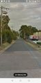
Google Street view of the gate - I forget to take a photo myself
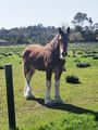
Clydesdale horse near hash
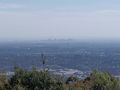
Melbourne city skyline from the top of Mt Dandenong


Achievements
Felix Dance earned the No trespassing consolation prize
|