Difference between revisions of "2020-12-31 51 9"
(new report) |
(expedition report for) |
||
| Line 1: | Line 1: | ||
| − | + | [[Image:{{{image|2020-04-28 51 9 GeorgDerReisende 1339.jpg}}}|thumb|left]] | |
| − | + | {{meetup graticule | |
| − | |||
| − | |||
| − | |||
| − | |||
| − | |||
| − | |||
| lat=51 | | lat=51 | ||
| lon=9 | | lon=9 | ||
| date=2020-12-31 | | date=2020-12-31 | ||
| − | }} | + | }} |
| + | |||
__NOTOC__ | __NOTOC__ | ||
== Location == | == Location == | ||
| − | + | ||
| + | The hash lay on a field northeast of Vollmarshausen. | ||
== Participants == | == Participants == | ||
| − | + | ||
| − | + | [[User:GeorgDerReisende|GeorgDerReisende]] | |
== Plans == | == Plans == | ||
| − | + | ||
| + | As a Last Day of the Year Expedition it was the plan to walk around Vollmarshausen, then to the hash and then to Kassel. | ||
== Expedition == | == Expedition == | ||
| − | |||
| − | + | I rolled out of bed a little late and found the sun shining. But the weather report told something about rain. Immediately I started the expedition and withdrew the part of walking around Vollmarshausen. The planning showed me that the hash lay on a field which I passed on my expedition to [[2020-04-28 51 9]]. In the spring it was a field of asparagus. Today there were some little plants. The hash lay more than five meters into the field and I did these some steps until I got the five meter shot and returned to the field way. | |
| − | |||
== Photos == | == Photos == | ||
| − | < | + | |
| − | + | <gallery> | |
| − | -- | + | File:2020-04-28 51 9 GeorgDerReisende 1339.jpg | situation in spring 2020 |
| − | + | File:2020-04-28 51 9 GeorgDerReisende 1340.jpg | the field in spring 2020 | |
| + | </gallery> | ||
| + | <gallery> | ||
| + | File:2020-12-31 51 9 GeorgDerReisende 1220.jpg | arrived at Vollmarshausen | ||
| + | File:2020-12-31 51 9 GeorgDerReisende 1224.jpg | situation in winter 2020 | ||
| + | File:2020-12-31 51 9 GeorgDerReisende 1227.jpg | proof | ||
| + | File:2020-12-31 51 9 GeorgDerReisende 1228.jpg | looking north | ||
| + | File:2020-12-31 51 9 GeorgDerReisende 1229.jpg | west | ||
| + | File:2020-12-31 51 9 GeorgDerReisende 1230.jpg | south | ||
| + | File:2020-12-31 51 9 GeorgDerReisende 1231.jpg | east | ||
| + | File:2020-12-31 51 9 GeorgDerReisende 1232.jpg | the grin | ||
| + | File:2020-12-31 51 9 GeorgDerReisende 1233.jpg | looking from the north | ||
</gallery> | </gallery> | ||
== Achievements == | == Achievements == | ||
{{#vardefine:ribbonwidth|800px}} | {{#vardefine:ribbonwidth|800px}} | ||
| − | |||
| − | + | {{Déjà vu geohash | latitude = 51 | longitude = 9 | date = 2020-12-31 | olddate = 2020-04-28 51 9 }} | |
| − | |||
| − | |||
| − | + | [[Category:Expeditions]] | |
| − | + | [[Category:Expeditions with photos]] | |
| − | |||
| − | |||
| − | |||
| − | |||
| − | |||
| − | |||
| − | |||
| − | |||
| − | |||
| − | |||
| − | |||
| − | |||
| − | |||
| − | |||
[[Category:Coordinates reached]] | [[Category:Coordinates reached]] | ||
| − | |||
| − | |||
| − | |||
| − | |||
| − | |||
| − | |||
| − | |||
| − | |||
| − | |||
| − | |||
| − | |||
| − | |||
| − | |||
| − | |||
| − | |||
| − | |||
| − | |||
| − | |||
Revision as of 16:07, 31 December 2020

| Thu 31 Dec 2020 in 51,9: 51.2669217, 9.5719948 geohashing.info google osm bing/os kml crox |
Location
The hash lay on a field northeast of Vollmarshausen.
Participants
Plans
As a Last Day of the Year Expedition it was the plan to walk around Vollmarshausen, then to the hash and then to Kassel.
Expedition
I rolled out of bed a little late and found the sun shining. But the weather report told something about rain. Immediately I started the expedition and withdrew the part of walking around Vollmarshausen. The planning showed me that the hash lay on a field which I passed on my expedition to 2020-04-28 51 9. In the spring it was a field of asparagus. Today there were some little plants. The hash lay more than five meters into the field and I did these some steps until I got the five meter shot and returned to the field way.
Photos
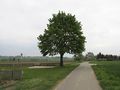
situation in spring 2020
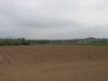
the field in spring 2020

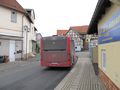
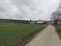
arrived at Vollmarshausen
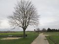
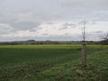
situation in winter 2020
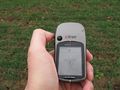
proof
looking north
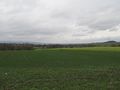
west
south
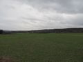
east
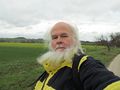
the grin
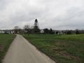
looking from the north


Achievements
This user earned the Déjà Vu Geohash Achievement
|