Difference between revisions of "2011-05-31 42 -91"
imported>Goobergunch (created page) |
|||
| (5 intermediate revisions by 3 users not shown) | |||
| Line 1: | Line 1: | ||
| − | |||
| − | |||
| − | |||
| − | |||
| − | |||
| − | |||
| − | |||
| − | |||
| − | |||
| − | |||
{{meetup graticule | {{meetup graticule | ||
| lat=42 | | lat=42 | ||
| lon=-91 | | lon=-91 | ||
| date=2011-05-31 | | date=2011-05-31 | ||
| + | | graticule_name = Cedar Rapids North | ||
| + | | graticule_link = Cedar Rapids North, Iowa | ||
}} | }} | ||
| − | |||
__NOTOC__ | __NOTOC__ | ||
== Location == | == Location == | ||
| − | + | ||
| + | In (or on a bank of) Buffalo Creek in the northwest outskirts of Anamosa, Iowa, south of Buffalo Road. | ||
== Participants == | == Participants == | ||
| − | + | *[[User:Goobergunch|Goobergunch]] | |
| − | == | + | == Expedition == |
| − | + | The geohash appeared to be under some trees on the outer edges of Anamosa. I drove up from Iowa City, through Anamosa, and parked near what appeared to be a construction site. However, nobody was around. (After getting out of my car, I didn't see a single person other than the inhabitants of cars driving on the road.) I walked down to Buffalo Road and headed east towards the geohash location. | |
| − | + | I soon discovered that while the hash was on public, theoretically accessible property, venturing south from the road to the hash would involve trudging through grass significantly taller and thicker than I was dressed for, while being attacked by swarms of gnats. | |
| − | |||
| − | + | The longitude of the hash turned out to be on the bridge over Buffalo Creek, and as actually getting to the hash would have probably involved wading into the river, I decided to just take a picture from the bridge and not venture further today. | |
| − | |||
== Photos == | == Photos == | ||
| − | + | ||
| − | |||
| − | |||
<gallery perrow="5"> | <gallery perrow="5"> | ||
| + | Image:2011-05-31 42 -91.jpg | A view of Buffalo Creek south of the bridge. The geohash was probably on the east (left) bank. | ||
</gallery> | </gallery> | ||
| − | |||
| − | |||
| − | |||
| − | |||
| − | |||
| − | |||
| − | |||
| − | |||
| − | |||
| − | |||
| − | |||
| − | |||
| − | |||
| − | |||
[[Category:Expeditions]] | [[Category:Expeditions]] | ||
| − | |||
[[Category:Expeditions with photos]] | [[Category:Expeditions with photos]] | ||
| − | |||
| − | |||
| − | |||
| − | |||
| − | |||
| − | |||
| − | |||
| − | |||
| − | |||
[[Category:Coordinates not reached]] | [[Category:Coordinates not reached]] | ||
| − | + | [[Category:Not reached - Mother Nature]] | |
| − | [[Category:Not reached - Mother Nature]] | + | {{location|US|IA|JN}} |
| − | |||
| − | |||
| − | |||
| − | |||
Latest revision as of 16:59, 28 January 2021
| Tue 31 May 2011 in Cedar Rapids North: 42.1127651, -91.3005648 geohashing.info google osm bing/os kml crox |
Location
In (or on a bank of) Buffalo Creek in the northwest outskirts of Anamosa, Iowa, south of Buffalo Road.
Participants
Expedition
The geohash appeared to be under some trees on the outer edges of Anamosa. I drove up from Iowa City, through Anamosa, and parked near what appeared to be a construction site. However, nobody was around. (After getting out of my car, I didn't see a single person other than the inhabitants of cars driving on the road.) I walked down to Buffalo Road and headed east towards the geohash location.
I soon discovered that while the hash was on public, theoretically accessible property, venturing south from the road to the hash would involve trudging through grass significantly taller and thicker than I was dressed for, while being attacked by swarms of gnats.
The longitude of the hash turned out to be on the bridge over Buffalo Creek, and as actually getting to the hash would have probably involved wading into the river, I decided to just take a picture from the bridge and not venture further today.
Photos
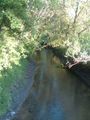
A view of Buffalo Creek south of the bridge. The geohash was probably on the east (left) bank.
