Difference between revisions of "2021-02-16 32 -96"
(→Location) |
m (Location) |
||
| (14 intermediate revisions by 2 users not shown) | |||
| Line 1: | Line 1: | ||
| − | + | {{meetup graticule | |
| − | |||
| − | |||
| − | |||
| − | |||
| − | |||
| − | |||
| − | |||
| − | |||
| lat=32 | | lat=32 | ||
| lon=-96 | | lon=-96 | ||
| date=2021-02-16 | | date=2021-02-16 | ||
| − | }} | + | }} |
__NOTOC__ | __NOTOC__ | ||
== Location == | == Location == | ||
| Line 17: | Line 9: | ||
On the property of the Dallas Love Field airport. Exact hash location outside of the terminal and thus unreachable. | On the property of the Dallas Love Field airport. Exact hash location outside of the terminal and thus unreachable. | ||
| + | |||
| + | what3words: [https://w3w.co/socket.chins.blaze ///socket.chins.blaze] ([https://what3words.com/about-us/ what is this?]) | ||
== Participants == | == Participants == | ||
<!-- who attended: If you link to your wiki user name in this section, your expedition will be picked up by the various statistics generated for geohashing. You may use three tildes ~ as a shortcut to automatically insert the user signature of the account you are editing with. | <!-- who attended: If you link to your wiki user name in this section, your expedition will be picked up by the various statistics generated for geohashing. You may use three tildes ~ as a shortcut to automatically insert the user signature of the account you are editing with. | ||
--> | --> | ||
| + | * [[User:Gabe|Gabe]] ([[User talk:Gabe|talk]]) | ||
| + | * A bunch of other people in the airport (unbeknownst to them) | ||
== Plans == | == Plans == | ||
<!-- what were the original plans --> | <!-- what were the original plans --> | ||
| + | Had planned a flight from PHX to DAL. Was elated to discover that the daily hash was located on airport property. | ||
| + | The plan was made to attempt the closest possible approach without being arrested. | ||
== Expedition == | == Expedition == | ||
<!-- how it all turned out. your narrative goes here. --> | <!-- how it all turned out. your narrative goes here. --> | ||
| + | Unfortunately, the hash was not inside the terminal and was thus unable to be reached exactly. The closest (legal) approach was found to be at a distance of '''279 ft'''. | ||
| − | == | + | === Additional Note === |
| − | + | The expedition was made all the more exciting as it took place during an extreme episode of winter weather. Was retrieved by [[User:Luke|Luke]] following the hash, at which point we drove extremely slowly over snow and ice back to the safety of his apartment. | |
== Photos == | == Photos == | ||
| Line 36: | Line 35: | ||
--> | --> | ||
<gallery perrow="5"> | <gallery perrow="5"> | ||
| + | |||
| + | File:2021-02-16 32 -96 01.png | Hash location just outside of terminal | ||
| + | File:2021-02-16 32 -96 02.png | Closest approach | ||
| + | File:2021-02-16 32 -96 03.png | Measured at 279 ft from hash | ||
| + | File:2021-02-16 32 -96 04.jpg|upright=1.0|At hash location inside Love Field airport | ||
| + | File:2021-02-16 32 -96 05.jpg | Airport was very empty | ||
| + | |||
</gallery> | </gallery> | ||
| Line 42: | Line 48: | ||
<!-- Add any achievement ribbons you earned below, or remove this section --> | <!-- Add any achievement ribbons you earned below, or remove this section --> | ||
| − | + | {{land geohash | latitude = 32 | longitude = -96 | date = 2021-02-16 | name = Gabe | image = 2021-02-16 32 -96 04.jpg }} | |
| − | |||
| − | |||
| − | + | {{Frozen Geohash | |
| − | + | | latitude = 32 | |
| − | + | | longitude = -96 | |
| − | + | | date = 2021-02-16 | |
| − | -- | + | | temperature = 18°F |
| + | | name = Gabe | ||
| + | | image = 2021-02-16 32 -96 06.png | ||
| + | }} | ||
| − | |||
| − | |||
| − | |||
[[Category:Expeditions]] | [[Category:Expeditions]] | ||
| − | |||
[[Category:Expeditions with photos]] | [[Category:Expeditions with photos]] | ||
| − | |||
| − | |||
| − | |||
| − | |||
| − | |||
| − | |||
| − | |||
| − | |||
| − | |||
[[Category:Coordinates not reached]] | [[Category:Coordinates not reached]] | ||
| − | |||
| − | |||
| − | |||
| − | |||
| − | |||
[[Category:Not reached - No public access]] | [[Category:Not reached - No public access]] | ||
| − | + | {{location|US|TX|DS}} | |
| − | |||
| − | |||
| − | |||
| − | |||
| − | |||
| − | |||
| − | |||
Latest revision as of 13:42, 20 February 2021
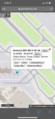
| Tue 16 Feb 2021 in 32,-96: 32.8456840, -96.8472644 geohashing.info google osm bing/os kml crox |
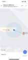
Location
On the property of the Dallas Love Field airport. Exact hash location outside of the terminal and thus unreachable.
what3words: ///socket.chins.blaze (what is this?)
Participants
Plans
Had planned a flight from PHX to DAL. Was elated to discover that the daily hash was located on airport property. The plan was made to attempt the closest possible approach without being arrested.
Expedition
Unfortunately, the hash was not inside the terminal and was thus unable to be reached exactly. The closest (legal) approach was found to be at a distance of 279 ft.
Additional Note
The expedition was made all the more exciting as it took place during an extreme episode of winter weather. Was retrieved by Luke following the hash, at which point we drove extremely slowly over snow and ice back to the safety of his apartment.
Photos
Hash location just outside of terminal

Closest approach
Measured at 279 ft from hash
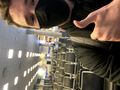
At hash location inside Love Field airport

Airport was very empty


Achievements
Gabe earned the Land geohash achievement
|

