Difference between revisions of "2013-03-09 30 -81"
imported>DrCanadianNinja (→The Adventure) |
m |
||
| (10 intermediate revisions by 3 users not shown) | |||
| Line 1: | Line 1: | ||
| + | {{Advert}} | ||
| + | |||
{{meetup graticule | {{meetup graticule | ||
| map=<map lat="30" lon="-81" date="2013-03-09" /> | | map=<map lat="30" lon="-81" date="2013-03-09" /> | ||
| Line 13: | Line 15: | ||
=== The Geohashers === | === The Geohashers === | ||
| − | * [[user: | + | * [[user:Geoffistopheles|Geoff]] |
* [[user:NinjaBait|Erica]] | * [[user:NinjaBait|Erica]] | ||
| + | |||
=== The Adventure === | === The Adventure === | ||
| − | + | So many of our geohashes just turn into "drive to the point, walk the last few feet, take pictures, drive back." With a hash like this, I couldn't let the opportunity to shake things up pass. | |
| + | |||
| + | We drove out to Friendship Fountain, which is a sizable fountain that doubles as a lightshow at night. From there, we picked up the S.S. Marine Taxi for the first time; we had seen them previously in [[2012-10-16_30_-81|our last downtown geohash]], but we had no reason to take it. It was a short ride, mainly because almost everyone onboard was going to the Landing. We did see a weird-looking building that I want to stop by later just to see what it actually was. | ||
| + | |||
| + | From the Landing, we took off east along the shoreline. This would be our first lengthy section of walking a geohash since a terrible one in Georgia, but thankfully I wouldn't be expected to juggernaut my way through bushes. Once we hit the docks, we made our way closer to the streets. Erica saw a dolphin on the way in, but I don't believe she got a picture of it. We continued on East Bay Street, past the Maxwell House factory, then north on A Philip Randolph Boulevard. We took a little detour once we hit Bragan Field so we (read: I) could get pictures of the baseball field and EverBank Field, where the Jaguars play. After that, a little confusion as to what roads lead where, we eventually got back on APR to Oakley Street, where the geohash was located. | ||
| + | |||
| + | Getting on the sidewalk, I saw my immediate problem: I was already on the northern set of coordinates. This would be fine if it weren't for the fact that the sidewalk twisted and turned, and by the time we would get to the house nearest to the geohash, I'd be running into the corner of a fence. I maintained my line, walking off the sidewalk when it would twist out of my way, and as fortune would have it, the geohash was right outside the corner of the fence. Happy day! | ||
| + | |||
| + | The GPS claims I've made a new record for the Low Geohash, but I'm not sure I want to take it. The picture I took says I was 27 feet below sea level, five feet lower than the current record also set by me. However, that seems awfully low for Jacksonville, even for something a mile or two away from the water. I certainly didn't feel a decline in elevation up to that point. For now, I'd rather just mention this as it is rather than take a new achievement for it. | ||
| + | |||
| + | We wrote on the Three of Clubs, but struggled to find a place to put it. I suggested on one of the trees outside EverBank, but Erica didn't want to go out of our way just to place a marker. We ended up making the two mile walk back, pretty much as a beeline, and grabbed dinner at the Landing. Initially we had planned on a restaurant nearby that we had coupons for; we settled for a food court. Neither of us was really in the mood at that point. Some more pictures with Erica's flashy new camera as the sun went down and we were back on the Marine Taxi heading back home. | ||
== Gallery == | == Gallery == | ||
| + | <gallery caption="Photo Gallery" widths="200px" heights="200px" perrow="4"> | ||
| + | Image:2013-03-09_30_-81_FriendshipFountain.JPG|A rather large fountain near where we parked on the south side of the river. | ||
| + | Image:2013-03-09_30_-81_MarineTaxi.JPG|While not running, this was a carbon copy of the boat we took over. | ||
| + | Image:2013-03-09_30_-81_Landing.JPG|Jacksonville Landing from the south side. | ||
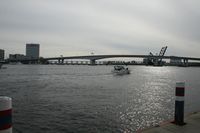
| + | Image:2013-03-09_30_-81_Drawbridge.JPG|One of the seven bridges over the St. John's River. | ||
| + | Image:2013-03-09_30_-81_LandingOff.JPG|Oh good, they fixed their plumbing problem. | ||
| + | Image:2013-03-09_30_-81_StJohns.JPG| | ||
| + | Image:2013-03-09_30_-81_Boats.JPG| | ||
| + | Image:2013-03-09_30_-81_Dolphin.JPG|I like how the picture implies it's a manatee. | ||
| + | Image:2013-03-09_30_-81_BraganField.JPG|This is where the AA league Jacksonville Suns play. | ||
| + | Image:2013-03-09_30_-81_EverBank.JPG|Right across the street is where the Jaguars play! | ||
| + | Image:2013-03-09_30_-81_Baseball.JPG|We got to peer in at the field. | ||
| + | Image:2013-03-09_30_-81_GeohashHouse.JPG|Approaching coordinates... | ||
| + | Image:2013-03-09_30_-81_GPSDance.JPG|This GPS likes to wander... | ||
| + | Image:2013-03-09_30_-81_GPS.jpg|Success! | ||
| + | Image:2013-03-09_30_-81_Geohash.JPG|Right on this fence corner. | ||
| + | Image:2013-03-09_30_-81_GeohashN.JPG|Look at all the snow we had to trudge through! | ||
| + | Image:2013-03-09_30_-81_Geohashers.jpg|We were almost two blocks away before we realized we didn't take a picture of us. | ||
| + | Image:2013-03-09_30_-81_Tree.JPG|Erica thought this was pretty cool looking. | ||
| + | Image:2013-03-09_30_-81_OldStAndrews.JPG|Old St. Andrew's Episcopal Church. | ||
| + | Image:2013-03-09_30_-81_HappySpire.JPG|Happy Spire is glad you came to church! | ||
| + | Image:2013-03-09_30_-81_OldStAndrewsDoor.JPG|The church's front door. | ||
| + | Image:2013-03-09_30_-81_MaxwellHouse.JPG|Geoff silently mourns the tragedy of the leaking coffee building. | ||
| + | Image:2013-03-09_30_-81_AndrewJackson.JPG|Andrew Jackson, patron saint of twenty dollar bills. | ||
| + | Image:2013-03-09_30_-81_LandingOn.JPG|For the love of-AGAIN? These pipes must break like clockwork. | ||
| + | Image:2013-03-09_30_-81_Marker.jpg|3♣ | ||
| + | Image:2013-03-09_30_-81_Geoff.JPG|Ooh, whatcha doing? | ||
| + | Image:2013-03-09_30_-81_FriendshipFountainNight.JPG|Friendship Fountain lights up at night. | ||
| + | Image:2013-03-09_30_-81_DrawbridgeNight.JPG|So does the drawbridge! | ||
| + | Image:2013-03-09_30_-81_FriendshipFountainNightCloseup.JPG|Most night pictures turned out badly, but I thought this was worth keeping. | ||
| + | </gallery> | ||
== Achievables == | == Achievables == | ||
| + | {{gratuitous ribbon | ||
| + | | latitude = 30 | ||
| + | | longitude = -81 | ||
| + | | date = 2013-03-09 | ||
| + | | achievement = Triathalon achievement | ||
| + | | description = taking three modes of transportation (car, boat, and walking) on the way to the | ||
| + | | name = [[user:Geoffistopheles|Geoff]] | ||
| + | }} | ||
| + | {{Public transport geohash | ||
| + | | latitude = 30 | ||
| + | | longitude = -81 | ||
| + | | date = 2013-03-09 | ||
| + | | busline = Marine Taxi | ||
| + | | name = [[user:Geoffistopheles|Geoff]] | ||
| + | | image = 2013-03-09_30_-81_MarineTaxi.JPG | ||
| + | }} | ||
| + | |||
| + | |||
[[Category:Expeditions]] | [[Category:Expeditions]] | ||
| + | [[Category:Expeditions with photos]] | ||
| + | [[Category:Coordinates reached]] | ||
| + | {{location|US|FL|DU}} | ||
Latest revision as of 17:08, 24 March 2021
| Have you seen our geohashing marker? We'd love to hear from you! Click here to say "hi" and tell us what you've seen!
Curious about what geohashing is? Read more! |
| Sat 9 Mar 2013 in Jacksonville, Florida: 30.3306481, -81.6416891 geohashing.info google osm bing/os kml crox |
Expedition
The Plan
Bordering an empty lot and a house on Oakley Street. We're a bit apprehensive about this one as depending on which map we look at, it's on opposite sides of a fence, but we're going to make a stab at it anyway.
The Geohashers
The Adventure
So many of our geohashes just turn into "drive to the point, walk the last few feet, take pictures, drive back." With a hash like this, I couldn't let the opportunity to shake things up pass.
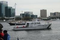
We drove out to Friendship Fountain, which is a sizable fountain that doubles as a lightshow at night. From there, we picked up the S.S. Marine Taxi for the first time; we had seen them previously in our last downtown geohash, but we had no reason to take it. It was a short ride, mainly because almost everyone onboard was going to the Landing. We did see a weird-looking building that I want to stop by later just to see what it actually was.
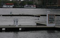
From the Landing, we took off east along the shoreline. This would be our first lengthy section of walking a geohash since a terrible one in Georgia, but thankfully I wouldn't be expected to juggernaut my way through bushes. Once we hit the docks, we made our way closer to the streets. Erica saw a dolphin on the way in, but I don't believe she got a picture of it. We continued on East Bay Street, past the Maxwell House factory, then north on A Philip Randolph Boulevard. We took a little detour once we hit Bragan Field so we (read: I) could get pictures of the baseball field and EverBank Field, where the Jaguars play. After that, a little confusion as to what roads lead where, we eventually got back on APR to Oakley Street, where the geohash was located.
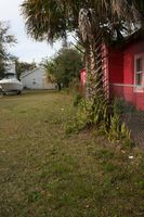
Getting on the sidewalk, I saw my immediate problem: I was already on the northern set of coordinates. This would be fine if it weren't for the fact that the sidewalk twisted and turned, and by the time we would get to the house nearest to the geohash, I'd be running into the corner of a fence. I maintained my line, walking off the sidewalk when it would twist out of my way, and as fortune would have it, the geohash was right outside the corner of the fence. Happy day!
The GPS claims I've made a new record for the Low Geohash, but I'm not sure I want to take it. The picture I took says I was 27 feet below sea level, five feet lower than the current record also set by me. However, that seems awfully low for Jacksonville, even for something a mile or two away from the water. I certainly didn't feel a decline in elevation up to that point. For now, I'd rather just mention this as it is rather than take a new achievement for it.
We wrote on the Three of Clubs, but struggled to find a place to put it. I suggested on one of the trees outside EverBank, but Erica didn't want to go out of our way just to place a marker. We ended up making the two mile walk back, pretty much as a beeline, and grabbed dinner at the Landing. Initially we had planned on a restaurant nearby that we had coupons for; we settled for a food court. Neither of us was really in the mood at that point. Some more pictures with Erica's flashy new camera as the sun went down and we were back on the Marine Taxi heading back home.
Gallery
- Photo Gallery
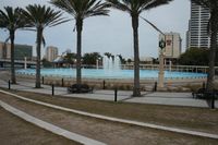
A rather large fountain near where we parked on the south side of the river.
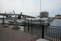
While not running, this was a carbon copy of the boat we took over.
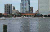
Jacksonville Landing from the south side.

One of the seven bridges over the St. John's River.

Oh good, they fixed their plumbing problem.
I like how the picture implies it's a manatee.
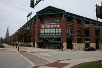
This is where the AA league Jacksonville Suns play.

Right across the street is where the Jaguars play!

We got to peer in at the field.

Approaching coordinates...

This GPS likes to wander...
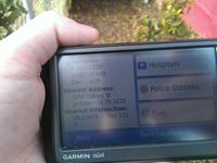
Success!

Right on this fence corner.
Look at all the snow we had to trudge through!
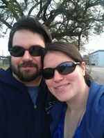
We were almost two blocks away before we realized we didn't take a picture of us.
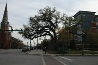
Erica thought this was pretty cool looking.

Old St. Andrew's Episcopal Church.

Happy Spire is glad you came to church!
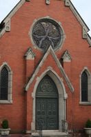
The church's front door.
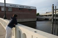
Geoff silently mourns the tragedy of the leaking coffee building.
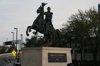
Andrew Jackson, patron saint of twenty dollar bills.

For the love of-AGAIN? These pipes must break like clockwork.

3♣
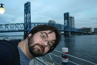
Ooh, whatcha doing?

Friendship Fountain lights up at night.

So does the drawbridge!
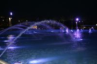
Most night pictures turned out badly, but I thought this was worth keeping.


Achievables
Geoff earned the Triathalon achievement
|
Geoff earned the Public transport geohash achievement
|