Difference between revisions of "2013-07-07 28 -82"
imported>DrCanadianNinja |
m |
||
| (4 intermediate revisions by 2 users not shown) | |||
| Line 1: | Line 1: | ||
| + | {{Advert}} | ||
| + | |||
{{meetup graticule | {{meetup graticule | ||
| map=<map lat="28" lon="-82" date="2013-07-07" /> | | map=<map lat="28" lon="-82" date="2013-07-07" /> | ||
| Line 13: | Line 15: | ||
=== The Geohashers === | === The Geohashers === | ||
| − | * [[user: | + | * [[user:Geoffistopheles|Geoff]] |
* [[user:NinjaBait|Erica]] | * [[user:NinjaBait|Erica]] | ||
| Line 19: | Line 21: | ||
What needs to be stressed about this adventure is how wholly it wasn't out of the way. From the route we had already planned to drive, it was a grand total of fifteen minutes to leave the highway, hit the geohash, and get back on the road. | What needs to be stressed about this adventure is how wholly it wasn't out of the way. From the route we had already planned to drive, it was a grand total of fifteen minutes to leave the highway, hit the geohash, and get back on the road. | ||
| − | Not much to say about this hash. It was inside Odessa Industrial Park, we were seeing restricted access signs further down the hash road, which was thankfully empty, the hash dance got a little annoying and sparked a desire for a new GPS or a Win8 app, followed by careful deliberation on what I'd put in an app like that, left the Six of Diamonds, and then we were gone | + | Once again, a Speed Racer would have been a bad idea, given that it was close to an intersection and the limit was 30 MPH. There was another hash tree, interesting considering there was one the day before, and I have no idea what kind of fruit that is, if it's fruit in the first place. Anyone? If need be, I can link to the original size. |
| + | |||
| + | Not much to say about this hash. It was inside Odessa Industrial Park, we were seeing restricted access signs further down the hash road, which was thankfully empty, Erica didn't bother bringing out her camera in favor of her phone, the hash dance got a little annoying and sparked a desire for a new GPS or a Win8 app, followed by careful deliberation on what I'd put in an app like that, left the Six of Diamonds, and then we were gone. | ||
== Gallery == | == Gallery == | ||
| − | + | <gallery caption="Photo Gallery" widths="200px" heights="200px" perrow="3"> | |
| + | Image:2013-07-07 28 -82_GPS.jpg|Success! | ||
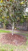
| + | Image:2013-07-07 28 -82_HashTree.jpg|The most interesting thing at the hash. | ||
| + | Image:2013-07-07 28 -82_Geohashers.jpg|Success! | ||
| + | Image:2013-07-07 28 -82_Security.jpg|Something tells me it wouldn't be terribly... | ||
| + | Image:2013-07-07 28 -82_NoTrespassing.jpg|...friendly if this were a weekday. | ||
| + | Image:2013-07-07 28 -82_GeohashN.jpg|At the hashpoint looking north. | ||
| + | Image:2013-07-07 28 -82_GeohashS.jpg|At the hashpoint looking south. | ||
| + | Image:2013-07-07 28 -82_Marker.jpg|6♦ | ||
| + | Image:2013-07-07 28 -82_MarkerLocation.jpg|On the aforementioned interesting tree. | ||
| + | </gallery> | ||
== Achieveables == | == Achieveables == | ||
| Line 29: | Line 43: | ||
| latitude = 28 | | latitude = 28 | ||
| longitude = -82 | | longitude = -82 | ||
| − | | date = 2013-07- | + | | date = 2013-07-06 |
| − | | name = [[user: | + | | name = [[user:Geoffistopheles|Geoff]] |
}} | }} | ||
[[Category:Expeditions]] | [[Category:Expeditions]] | ||
[[Category:Coordinates reached]] | [[Category:Coordinates reached]] | ||
| + | [[Category:Expeditions with photos]] | ||
| + | {{location|US|FL|PS}} | ||
Latest revision as of 17:09, 24 March 2021
| Have you seen our geohashing marker? We'd love to hear from you! Click here to say "hi" and tell us what you've seen!
Curious about what geohashing is? Read more! |
| Sun 7 Jul 2013 in Odessa, Florida: 28.1754668, -82.5963789 geohashing.info google osm bing/os kml crox |
Expedition
The Plan
What luck! This is right off the route we normally take to go back to Jacksonville. Swing by for a geohash before continuing on our way.
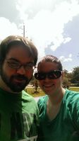
The Geohashers
The Adventure
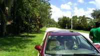
What needs to be stressed about this adventure is how wholly it wasn't out of the way. From the route we had already planned to drive, it was a grand total of fifteen minutes to leave the highway, hit the geohash, and get back on the road.
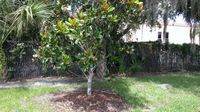
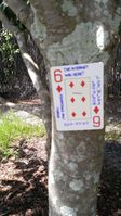
Once again, a Speed Racer would have been a bad idea, given that it was close to an intersection and the limit was 30 MPH. There was another hash tree, interesting considering there was one the day before, and I have no idea what kind of fruit that is, if it's fruit in the first place. Anyone? If need be, I can link to the original size.
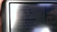
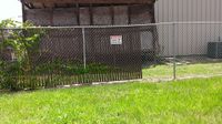
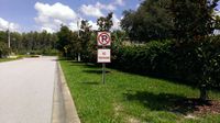
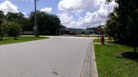
Not much to say about this hash. It was inside Odessa Industrial Park, we were seeing restricted access signs further down the hash road, which was thankfully empty, Erica didn't bother bringing out her camera in favor of her phone, the hash dance got a little annoying and sparked a desire for a new GPS or a Win8 app, followed by careful deliberation on what I'd put in an app like that, left the Six of Diamonds, and then we were gone.
Gallery
- Photo Gallery
Achieveables
Geoff earned the Consecutive geohash achievement
|
