Difference between revisions of "2021-03-27 51 13"
(Report!) |
|||
| Line 12: | Line 12: | ||
Country: Germany; state: Sachsen (Saxony, EU:DE:SN); district: Dresden; Stadtbezirk: Altstadt; Stadtteil (city district): Innere Altstadt | Country: Germany; state: Sachsen (Saxony, EU:DE:SN); district: Dresden; Stadtbezirk: Altstadt; Stadtteil (city district): Innere Altstadt | ||
| − | Weather: | + | Weather: clouded, no rain at hash o'clock |
==[[User:Danatar|Danatar]]== | ==[[User:Danatar|Danatar]]== | ||
=== Planning === | === Planning === | ||
| − | I will be at the hashpoint at 4 p.m. I'll probably walk there, as I'm still in my ''"walk along each and every street and path and dirt trail of ''Großer Garten'' park and even in between"'' project | + | I will be at the hashpoint at 4 p.m. I'll probably walk there, as I'm still in my ''"walk along each and every street and path and dirt trail of ''Großer Garten'' park and even in between"'' project. That project happens on all free weekend afternoons since February and it's already been 87 km within that 2 km² park. With it, I'm preparing for hashpoints in the park so I can get the déjà-vu achievement. |
The location is an "almost déjà-vu" location for me. I've never been at the exact spot but, since the location is near the city center and the main shopping mile, I've been all around the spot: I used the tramway 25m to the north/west and the road to the northeast/southeast/southwest (17 m, probably even the bike lane (15 m)); the city running event in 2015 went along the street north/northwest/west of the spot (45 m; the finishing line was 60-80 m north of the spot, according to the video I found on my computer). The geohashing expedition for [[2015-08-03 51 13]] passed west/north/east of the spot within 45 m, the tracklog link is broken though. | The location is an "almost déjà-vu" location for me. I've never been at the exact spot but, since the location is near the city center and the main shopping mile, I've been all around the spot: I used the tramway 25m to the north/west and the road to the northeast/southeast/southwest (17 m, probably even the bike lane (15 m)); the city running event in 2015 went along the street north/northwest/west of the spot (45 m; the finishing line was 60-80 m north of the spot, according to the video I found on my computer). The geohashing expedition for [[2015-08-03 51 13]] passed west/north/east of the spot within 45 m, the tracklog link is broken though. | ||
| − | == | + | === Expedition=== |
| + | I started my Saturday walk at 14:20. My project plan for the day were the flower gardens (as opposed to forest and meadows) northeast of the park's center. Because the weather was very clouded, only few people were around, so I could walk in circles and along strange routes without attracting attention (people would think: "that guy has walked around these benches 3 times now, I think he wants to steal my purse"). After a while, the weather got worse and the announced rain started. It was not very strong, but wet enough, so I walked through the forest parts for a while and even stood under the puppet theater building's awning for some minutes. | ||
| − | Then | + | Around 15:30 (after walking 4.5 km already) I started towards the hashpoint, closing some gaps in the project's tracklogs along the way. I left the park near the park railway's central station and walked along the ''Cockerwiese'' (a meadow named after the singer Joe Cocker, because he gave a famous open-air concert there in 1988 with 85000 guests). Then past the skate park towards the city hall, the tower of which was already visible straight ahead from ''Großer Garten''. I crossed the last road and was near the hashpoint at 15:55. Finding the correct spot was easy. Taking a panorama picture was not, but I finally succeded. A few minutes after 4 p.m., I went to the ''Trümmerfrau'' statue in front of the city hall, then went back to the park. I didn't see anybody else at the hashpoint, but I had already left by 16:05 so if Etodo came later I missed him. In the park I did another 7 km of walking, now mostly in the southern part. |
| − | + | In total, I walked 13.5 km in 3.5 hours. Without my long walk in the ''Großer Garten'', it would have been ~5.5 km from home or 2 km just from the edge of the park. | |
| − | |||
| + | {{gallery|width=200|height=200|lines=2 | ||
| + | |Image:2021-03-27_51_13_herkulesallee-groga.jpg|city hall from ''Großer Garten'' | ||
| + | |Image:2021-03-27_51_13_near.jpg|almost there | ||
| + | |Image:2021-03-27_51_13_gps.jpg|GPS | ||
| + | |Image:2021-03-27_51_13_hp.jpg|coordinates reached! | ||
| + | |Image:2021-03-27_51_13_spot.jpg|hashpoint | ||
| + | |Image:2021-03-27_51_13_pano.jpg|panorama | ||
| + | |Image:2021-03-27_51_13_truemmerfrau.jpg|statue | ||
| + | |Image:2021-03-27_51_13_blumen.jpg|flowers in ''Großer Garten'' | ||
| + | }} | ||
| + | ===tracklog=== | ||
| + | {{tracklog | 2021-03-27_51_13-triton.gpx}} | ||
| + | ==[[User:Etodo|Etodo]]== | ||
| + | Then we'll also try to be there at 4 pm. Given how close it is, we might go for a Juggernaut, Walk or even No batteries achievement | ||
| − | |||
| − | |||
| − | |||
| − | |||
| − | |||
| − | |||
| − | |||
[[Category:Expeditions]] | [[Category:Expeditions]] | ||
[[Category:Expeditions with photos]] | [[Category:Expeditions with photos]] | ||
| − | [[Category:Coordinates reached | + | [[Category:Coordinates reached]] |
[[Category:Danatar]] | [[Category:Danatar]] | ||
{{location|DE|SN|DD}} | {{location|DE|SN|DD}} | ||
Revision as of 20:25, 27 March 2021
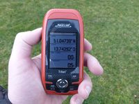
| Sat 27 Mar 2021 in Dresden: 51.0473875, 13.7429201 geohashing.info google osm bing/os kml crox |
Location
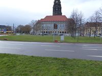
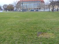
Today's location is on a small meadow next to the main road in front of Dresden's city hall (German wikipedia page)
Country: Germany; state: Sachsen (Saxony, EU:DE:SN); district: Dresden; Stadtbezirk: Altstadt; Stadtteil (city district): Innere Altstadt
Weather: clouded, no rain at hash o'clock
Danatar
Planning
I will be at the hashpoint at 4 p.m. I'll probably walk there, as I'm still in my "walk along each and every street and path and dirt trail of Großer Garten park and even in between" project. That project happens on all free weekend afternoons since February and it's already been 87 km within that 2 km² park. With it, I'm preparing for hashpoints in the park so I can get the déjà-vu achievement.
The location is an "almost déjà-vu" location for me. I've never been at the exact spot but, since the location is near the city center and the main shopping mile, I've been all around the spot: I used the tramway 25m to the north/west and the road to the northeast/southeast/southwest (17 m, probably even the bike lane (15 m)); the city running event in 2015 went along the street north/northwest/west of the spot (45 m; the finishing line was 60-80 m north of the spot, according to the video I found on my computer). The geohashing expedition for 2015-08-03 51 13 passed west/north/east of the spot within 45 m, the tracklog link is broken though.
Expedition
I started my Saturday walk at 14:20. My project plan for the day were the flower gardens (as opposed to forest and meadows) northeast of the park's center. Because the weather was very clouded, only few people were around, so I could walk in circles and along strange routes without attracting attention (people would think: "that guy has walked around these benches 3 times now, I think he wants to steal my purse"). After a while, the weather got worse and the announced rain started. It was not very strong, but wet enough, so I walked through the forest parts for a while and even stood under the puppet theater building's awning for some minutes.
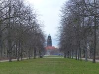
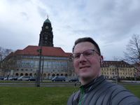
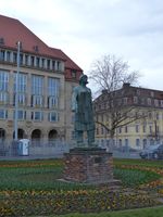
Around 15:30 (after walking 4.5 km already) I started towards the hashpoint, closing some gaps in the project's tracklogs along the way. I left the park near the park railway's central station and walked along the Cockerwiese (a meadow named after the singer Joe Cocker, because he gave a famous open-air concert there in 1988 with 85000 guests). Then past the skate park towards the city hall, the tower of which was already visible straight ahead from Großer Garten. I crossed the last road and was near the hashpoint at 15:55. Finding the correct spot was easy. Taking a panorama picture was not, but I finally succeded. A few minutes after 4 p.m., I went to the Trümmerfrau statue in front of the city hall, then went back to the park. I didn't see anybody else at the hashpoint, but I had already left by 16:05 so if Etodo came later I missed him. In the park I did another 7 km of walking, now mostly in the southern part.
In total, I walked 13.5 km in 3.5 hours. Without my long walk in the Großer Garten, it would have been ~5.5 km from home or 2 km just from the edge of the park.
|
tracklog
Etodo
Then we'll also try to be there at 4 pm. Given how close it is, we might go for a Juggernaut, Walk or even No batteries achievement
