Difference between revisions of "2010-12-02 49 11"
imported>Sp3pbn (Created page with '{{meetup graticule | map=<map lat="49" lon="11" date="2010-12-02" /> | lat=49 | lon=11 | date=2010-11-02 | graticule_name=Nürnberg | graticule_link=Nürnberg, Germany }} == Gra…') |
m (nickchange) |
||
| (4 intermediate revisions by 3 users not shown) | |||
| Line 3: | Line 3: | ||
| lat=49 | | lat=49 | ||
| lon=11 | | lon=11 | ||
| − | | date=2010- | + | | date=2010-12-02 |
| graticule_name=Nürnberg | | graticule_name=Nürnberg | ||
| graticule_link=Nürnberg, Germany | | graticule_link=Nürnberg, Germany | ||
| Line 34: | Line 34: | ||
== Gallery == | == Gallery == | ||
<gallery perrow="4"> | <gallery perrow="4"> | ||
| − | Image:2010-12-01_49_11_01.JPG|The field just right outside my town | + | Image:2010-12-01_49_11_01.JPG|The field just right outside of my town |
| − | Image:2010-12-01_49_11_02.JPG|Going down into the forest. I followed the hiking trail number "4" most of the time. | + | Image:2010-12-01_49_11_02.JPG|Going down into the forest. I followed the hiking trail number "4" for most of the time. |
Image:2010-12-01_49_11_03.JPG|A frozen pond in the forest. | Image:2010-12-01_49_11_03.JPG|A frozen pond in the forest. | ||
Image:2010-12-01_49_11_04.JPG|Fallen trees, below a small stream. | Image:2010-12-01_49_11_04.JPG|Fallen trees, below a small stream. | ||
| Line 54: | Line 54: | ||
| longitude = 11 | | longitude = 11 | ||
| date = 2010-12-02 | | date = 2010-12-02 | ||
| − | | name = | + | | name = sp3pbn |
| distance = 4km | | distance = 4km | ||
| Line 65: | Line 65: | ||
| date = 2010-12-02 | | date = 2010-12-02 | ||
| temperature = -7°C | | temperature = -7°C | ||
| − | | name = | + | | name = sp3pbn |
| − | |||
}} | }} | ||
| Line 74: | Line 73: | ||
[[Category:Expeditions]] | [[Category:Expeditions]] | ||
[[Category:Coordinates reached]] | [[Category:Coordinates reached]] | ||
| + | {{location|DE|BY|LAU}} | ||
Latest revision as of 07:42, 14 April 2021
| Thu 2 Dec 2010 in Nürnberg: 49.5637904, 11.2046252 geohashing.info google osm bing/os kml crox |
Graticule
Location
On a field between the towns Eckental and Beerbach
Participants
Expedition
I checked the coordinates the evening before and was like "wohoo, in walking distance" (about 2km) and then even like "wohoo, I have spare time in the afternoon"
The plan was clear and after returning home in the afternoon the weather was even better than I could have hoped after the last days of nearly non-stop-snowing, the sky was partly blue and even the sun could be seen from time to time. Perfect weather for a walk outside in the snow.
So after a quick grabbing of electronic devices and changing clothes I went out, walked through some lovely forest and fields, while I took lots of photos, until my satnav said "Sie haben ihr Ziel erreicht" what means "You have reached your destination" and enjoyed the nice view I had from there.
Pictures talk for themselves (they are all a bit dark, my cam is shitty)
I claim the walking geohash and the frozen geohash achievement. I have no real proof for both, but the pictures might show, that I must have walked, and there is lots of snow on them. The thermometer at home showed about -7°C.
Gallery
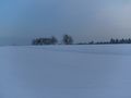
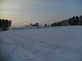
The field just right outside of my town
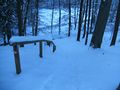
Going down into the forest. I followed the hiking trail number "4" for most of the time.
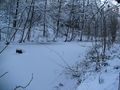
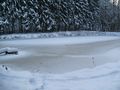
A frozen pond in the forest.
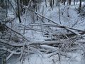
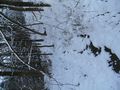
Fallen trees, below a small stream.
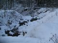
The same stream making its way through the snow.
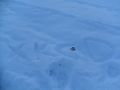
There were some animals before me.
Another pond. My region is famous for them, containing delicious carps.
My satnav showed this as a street to drive on. Very funny.
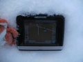
Coordinates reached. (yeah it’s not that good proof, but hopefully enough)
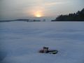
My hascot and the setting sun. It needs a name yet, maybe he will become "Fjodor".
Internet was here!


Achievements
sp3pbn earned the Walk geohash Achievement
|
