Difference between revisions of "2009-04-22 50 7"
imported>Lavataucher |
m |
||
| (2 intermediate revisions by 2 users not shown) | |||
| Line 7: | Line 7: | ||
== About == | == About == | ||
| − | The spot | + | The spot is located near Ötzingen/Helferskirchen and was easy reachable by feet. I had to cruise about 8km, would be a shame if i missed that hash ;) |
== Expedition by [[User:Lavataucher|Lavataucher]] == | == Expedition by [[User:Lavataucher|Lavataucher]] == | ||
| Line 25: | Line 25: | ||
</gallery> | </gallery> | ||
| − | + | [[Category:Expeditions]] | |
[[Category:Expeditions with photos]] | [[Category:Expeditions with photos]] | ||
[[Category:Coordinates reached]] | [[Category:Coordinates reached]] | ||
| + | {{location|DE|RP|WW}} | ||
Latest revision as of 12:28, 19 April 2021
| Wed 22 Apr 2009 in Bonn: 50.5132177, 7.8289874 geohashing.info google osm bing/os kml crox |
About
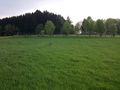
The spot is located near Ötzingen/Helferskirchen and was easy reachable by feet. I had to cruise about 8km, would be a shame if i missed that hash ;)
Expedition by Lavataucher
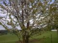
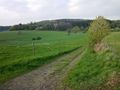
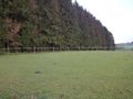
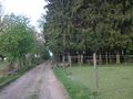
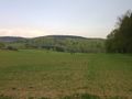
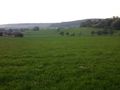
This time i visited the spot on my own - i wasn't able to convince anyone to come with me. Shame on them, the weather was beautiful, the meadows were green and there were a lot of cows :D I left my car at Helferskirchen and decided to have a nice walk to the hash. It first seemed that the spot would be unreachable (lots of cows, fences everywhere), but as i approached the coordinates the hash turned out to be an open meadow with knee-deep grass. I sat down for a couple of minutes to enjoy the nice view and the fresh air, then went back and drove home.
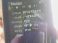
GPS shot, lots of deviation :(
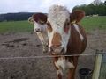
moo!
i really enjoyed that view
standing at the hash
surprise! wrong camera!