Difference between revisions of "2009-04-28 32 -90"
imported>Uglystick |
m |
||
| (4 intermediate revisions by 2 users not shown) | |||
| Line 7: | Line 7: | ||
== About == | == About == | ||
| − | The sixth geohash for my home graticule was pretty simple - a mere 5 km from my house. A quick, easy geohash I could snag on the way home from work - or so I thought. | + | The sixth geohash for my ([[User:Uglystick|Uglystick's]]) home graticule was pretty simple - a mere 5 km from my house. A quick, easy geohash I could snag on the way home from work - or so I thought. |
== Expedition == | == Expedition == | ||
| − | I was able to drive almost all the way to the point. The last 20 meters, however, were much more difficult. | + | I was able to drive almost all the way to the point. The last 20 meters, however, were much more difficult. It was a steep slope covered with all kinds of Mississippi woodland underbrush which prominently features poison ivy. It had rained earlier in the day and everything was still wet and slick. Not a very fun slope to climb down, particularly in my office duds. Since this was a spontaneous geohash on my way home from work, I wasn't quite prepared to go mucking about much in the jungle-type woods that Mississippi often features. I got close enough to be within the GPS tolerance of the point, although truth be told, I was probably a good 2-3 meters west of the point. In any case, my picture easily captured the true point so I'm calling this point hashed! |
<gallery> | <gallery> | ||
| − | Image:2009-04-28- | + | Image:2009-04-28-W32-N90-1.jpg|Driving to within 20m of the point was easy |
Image:2009-04-28-N32-W90-2.jpg|Getting down the slope of the last 20m was not | Image:2009-04-28-N32-W90-2.jpg|Getting down the slope of the last 20m was not | ||
Image:2009-04-28-N32-W90-3.jpg|The point was in a bed of poison ivy | Image:2009-04-28-N32-W90-3.jpg|The point was in a bed of poison ivy | ||
| Line 19: | Line 19: | ||
</gallery> | </gallery> | ||
| + | [[Category:Expeditions]] | ||
[[Category:Expeditions with photos]] | [[Category:Expeditions with photos]] | ||
[[Category:Coordinates reached]] | [[Category:Coordinates reached]] | ||
| + | {{location|US|MS|WR}} | ||
Latest revision as of 17:41, 19 April 2021
| Tue 28 Apr 2009 in Jackson, MS: 32.2375398, -90.8303430 geohashing.info google osm bing/os kml crox |
About
The sixth geohash for my (Uglystick's) home graticule was pretty simple - a mere 5 km from my house. A quick, easy geohash I could snag on the way home from work - or so I thought.
Expedition
I was able to drive almost all the way to the point. The last 20 meters, however, were much more difficult. It was a steep slope covered with all kinds of Mississippi woodland underbrush which prominently features poison ivy. It had rained earlier in the day and everything was still wet and slick. Not a very fun slope to climb down, particularly in my office duds. Since this was a spontaneous geohash on my way home from work, I wasn't quite prepared to go mucking about much in the jungle-type woods that Mississippi often features. I got close enough to be within the GPS tolerance of the point, although truth be told, I was probably a good 2-3 meters west of the point. In any case, my picture easily captured the true point so I'm calling this point hashed!
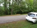
Driving to within 20m of the point was easy
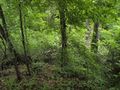
Getting down the slope of the last 20m was not
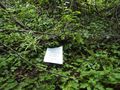
The point was in a bed of poison ivy
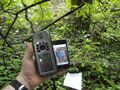
We're within GPS accuracy - it's a hashed point!


