Difference between revisions of "2009-09-09 40 -111"
From Geohashing
(New page: {{subst:Expedition |lat = latitude of graticule |lon = longitude of graticule |date = date of expedition, in YYYY-MM-DD format }}) |
|||
| (9 intermediate revisions by 4 users not shown) | |||
| Line 1: | Line 1: | ||
| − | |||
<!-- If you did not specify these parameters in the template, please substitute appropriate things for IMAGE, LAT, LON, and DATE (YYYY-MM-DD format) --> | <!-- If you did not specify these parameters in the template, please substitute appropriate things for IMAGE, LAT, LON, and DATE (YYYY-MM-DD format) --> | ||
<!-- | <!-- | ||
| Line 5: | Line 4: | ||
--> | --> | ||
{{meetup graticule | {{meetup graticule | ||
| − | | lat= | + | | lat=40 |
| − | | lon= | + | | lon=-111 |
| − | | date= | + | | date=2009-09-09 |
}} | }} | ||
| Line 13: | Line 12: | ||
__NOTOC__ | __NOTOC__ | ||
== Location == | == Location == | ||
| − | + | Right off the highway in the yard of some abandoned home. | |
== Participants == | == Participants == | ||
| − | + | [[User:GarafaJon|GarafaJon]], [[User:GarafaSpencer|GarafaSpencer]] | |
== Plans == | == Plans == | ||
| Line 25: | Line 24: | ||
== Tracklog == | == Tracklog == | ||
| − | + | Tracklog can be seen [http://maps.google.com/maps?q=http://www.garafa.com/GPSKit/tracks/383ba31825d580648d10c53f884b5343823f5759_84.kml here]. | |
== Photos == | == Photos == | ||
| Line 35: | Line 34: | ||
--> | --> | ||
<gallery perrow="3"> | <gallery perrow="3"> | ||
| − | + | Image:2009-09-09 40 -111 Toothy Grin.jpg | Spencer's grin! | |
</gallery> | </gallery> | ||
| + | {{gratuitous ribbon | ||
| − | + | | color = red | |
| − | + | | icon = 999.png | |
| − | [[ | + | | latitude = 40 |
| − | + | | longitude = -111 | |
| + | | date = 2009-09-09 | ||
| + | | achievement = number of the ʇsɐǝq gratuitous ribbon | ||
| + | | description = reaching the | ||
| + | | name = [[User:GarafaJon|GarafaJon]] and [[User:GarafaSpencer|GarafaSpencer]] | ||
| + | }} | ||
| − | |||
[[Category:Expeditions]] | [[Category:Expeditions]] | ||
| − | |||
[[Category:Expeditions with photos]] | [[Category:Expeditions with photos]] | ||
| − | |||
| − | |||
| − | |||
| − | |||
| − | |||
[[Category:Coordinates reached]] | [[Category:Coordinates reached]] | ||
| − | + | {{location|US|UT|UT}} | |
| − | |||
| − | |||
| − | |||
| − | |||
| − | |||
| − | |||
| − | |||
| − | |||
| − | |||
Latest revision as of 17:54, 19 April 2021
| Wed 9 Sep 2009 in 40,-111: 40.1304633, -111.5850886 geohashing.info google osm bing/os kml crox |
Location
Right off the highway in the yard of some abandoned home.
Participants
Plans
Expedition
Tracklog
Tracklog can be seen here.
Photos
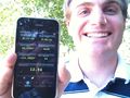
Spencer's grin!

GarafaJon and GarafaSpencer earned the number of the ʇsɐǝq gratuitous ribbon
|