Difference between revisions of "2021-06-24 42 -78"
Pedalpusher (talk | contribs) (New report) |
Pedalpusher (talk | contribs) m (fixed link) |
||
| (2 intermediate revisions by 2 users not shown) | |||
| Line 14: | Line 14: | ||
Since I was using the HashDroid app, I couldn't get my speed at the same time, so I didn't worry about that. I was hoping my slower speed would allow me to get a better reading than 16 feet, but it'll work. Continuing to drive, I was able to hit the camera (power button twice so I didn't have to look) and got a shot looking down Kenmore (after the hash). At the red light, I got a Stupid Grin picture and then continued on to my parents. | Since I was using the HashDroid app, I couldn't get my speed at the same time, so I didn't worry about that. I was hoping my slower speed would allow me to get a better reading than 16 feet, but it'll work. Continuing to drive, I was able to hit the camera (power button twice so I didn't have to look) and got a shot looking down Kenmore (after the hash). At the red light, I got a Stupid Grin picture and then continued on to my parents. | ||
| − | This turned into the Start of a Consecutive Hash and [[2021-06-25 | + | This turned into the Start of a Consecutive Hash and [[2021-06-25 43 -78|tomorrow's hash can be found here]]. |
== Photos == | == Photos == | ||
<gallery perrow="7"> | <gallery perrow="7"> | ||
| − | Image: | + | Image:2021-06-24 hashDroid.png| Driving through the hash. |
| − | Image: | + | Image:2021-06-24 view.jpg| View of Kenmore Ave after the hash. |
| − | Image: | + | Image:2021-06-24 stupidGrin.jpg| Stupid Grin still in the car. |
| − | |||
| − | |||
| − | |||
| − | |||
</gallery> | </gallery> | ||
| Line 34: | Line 30: | ||
}} | }} | ||
| − | |||
[[Category:Expeditions]] | [[Category:Expeditions]] | ||
[[Category:Coordinates reached]] | [[Category:Coordinates reached]] | ||
| − | + | [[Category:Expeditions with photos]] | |
| + | {{location|US|NY|ER}} | ||
Latest revision as of 16:16, 28 June 2021
| Thu 24 Jun 2021 in 42,-78: 42.9681678, -78.9011025 geohashing.info google osm bing/os kml crox |
Contents
[hide]Location
Middle of Kenmore Ave in Tonawanda
Participants
Expedition
Being my father's Birthday, I was already planning on driving into the city to have dinner at my parents. Now I would have a tighter schedule, but I could drive through the Geohash on my way. Looking at the satellite pictures, I didn't think I would be able to park there so it would have to be a drive-thru. I've never been down that section of road before, but I knew there really wasn't much over there so there shouldn't be much traffic. Maybe I could even stop in the middle of the road if there was no one around...
Getting close to quitting time, I made sure to get the dogs ready so I could leave right away. I knew the way, so I just needed to get there, but ran into some heavy traffic on the way. Getting past there, I was easily able to find and drive down Kenmore and started the HashDroid app. There wasn't anyone close to me, but someone was driving far behind me. As I approached the hash, I was able to slow down, but couldn't stop. I saw the distance drop, but didn't go lower than 13 feet or so. I was able to grab a screenshot, but being in the middle of the road, I definitely drove through it.
Since I was using the HashDroid app, I couldn't get my speed at the same time, so I didn't worry about that. I was hoping my slower speed would allow me to get a better reading than 16 feet, but it'll work. Continuing to drive, I was able to hit the camera (power button twice so I didn't have to look) and got a shot looking down Kenmore (after the hash). At the red light, I got a Stupid Grin picture and then continued on to my parents.
This turned into the Start of a Consecutive Hash and tomorrow's hash can be found here.
Photos
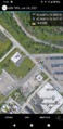
Driving through the hash.
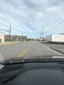
View of Kenmore Ave after the hash.

Stupid Grin still in the car.


Ribbons
This user earned the Land geohash achievement
|