Difference between revisions of "2021-05-29 60 25"
From Geohashing
(→Expedition) |
(→Expedition) |
||
| (4 intermediate revisions by the same user not shown) | |||
| Line 14: | Line 14: | ||
==Expedition== | ==Expedition== | ||
| − | The hashpoint was around 13 km from my home as the crow flies, but I cycled +20km to site, without the aid of gps and ended just ~ 5 meters apart from the geohash. I was in the right side of the path but the hashpoint was actually on the left shown in the panorama picture below. | + | The hashpoint was around 13 km from my home as the crow flies, but I cycled +20km to site, without the aid of guidance or gps and ended just ~ 5 meters apart from the geohash. I was in the right side of the path but the hashpoint was actually on the left shown in the panorama picture below. |
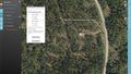
| − | As a preparation I have checked the location near the power line from the [https://asiointi.maanmittauslaitos.fi/karttapaikka/?lang=fi&share=customMarker&n=6683482.044834838&e=400374.69090472435&title=Geohash%202021-0529%2060%2025&desc=&zoom=12&layers=%5B%7B%22id%22:2,%22opacity%22:100%7D%5D kansalaisen karttapaikka] and measured the distance from the the mobile tower 80m. | + | As a preparation I have checked the location near the power line from the [https://asiointi.maanmittauslaitos.fi/karttapaikka/?lang=fi&share=customMarker&n=6683482.044834838&e=400374.69090472435&title=Geohash%202021-0529%2060%2025&desc=&zoom=12&layers=%5B%7B%22id%22:2,%22opacity%22:100%7D%5D kansalaisen karttapaikka] and measured the distance from the the mobile tower 80m that white building peeking in the left of panorama. |
==Photos== | ==Photos== | ||
[[File:2021-05-29 60 25 05 Surroundings.jpg|1000px|Surroundings]] | [[File:2021-05-29 60 25 05 Surroundings.jpg|1000px|Surroundings]] | ||
<gallery> | <gallery> | ||
| − | 2021-05-29 60 25 01 place.jpg | In place | + | 2021-05-29 60 25 01 place.jpg | In the place |
2021-05-29 60 25 02 Site.jpg | The site of the Geohash | 2021-05-29 60 25 02 Site.jpg | The site of the Geohash | ||
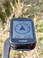
2021-05-29 60 25 03 Proof.jpg | Proof | 2021-05-29 60 25 03 Proof.jpg | Proof | ||
| − | 2021-05-29 60 25 04 Geohash.jpg | The Geohash | + | 2021-05-29 60 25 04 Geohash.jpg | The Geohash and my cycling shoes |
</gallery> | </gallery> | ||
| Line 30: | Line 30: | ||
{{#vardefine:ribbonwidth|100%}} | {{#vardefine:ribbonwidth|100%}} | ||
{{land geohash|date=2021-05-29|latitude=60|longitude=25|name=[[User:PPP|PPP]]}} | {{land geohash|date=2021-05-29|latitude=60|longitude=25|name=[[User:PPP|PPP]]}} | ||
| + | {{Bicycle geohash | latitude = 60 | longitude = 25 | date = 2021-05-29 | name = PPP }} | ||
__NOTOC__ | __NOTOC__ | ||
Latest revision as of 08:18, 10 August 2021
| Sat 29 May 2021 in Vantaa: 60.2756551, 25.1987215 geohashing.info google osm bing/os kml crox |
Location
This Geohash is located on a small hill in the woods near to knutersintie Landbo Helsinki
Participants
Expedition
The hashpoint was around 13 km from my home as the crow flies, but I cycled +20km to site, without the aid of guidance or gps and ended just ~ 5 meters apart from the geohash. I was in the right side of the path but the hashpoint was actually on the left shown in the panorama picture below.
As a preparation I have checked the location near the power line from the kansalaisen karttapaikka and measured the distance from the the mobile tower 80m that white building peeking in the left of panorama.
Photos

In the place
The site of the Geohash
Proof
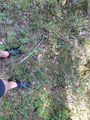
The Geohash and my cycling shoes


Achievements
PPP earned the Land geohash achievement
|
PPP earned the Bicycle geohash achievement
|