Difference between revisions of "2008-07-04 40 -88"
imported>Thomcat (Success/failure category added) |
imported>FippeBot m (Location) |
||
| Line 21: | Line 21: | ||
[[Category:Expeditions with photos]] | [[Category:Expeditions with photos]] | ||
[[Category:Coordinates reached]] | [[Category:Coordinates reached]] | ||
| + | {{location|US|IL|ML}} | ||
Latest revision as of 05:41, 7 August 2019
| Fri 4 Jul 2008 in 40,-88: 40.4130070, -88.7311430 geohashing.info google osm bing/os kml crox |
These Independence Day coordinates fell right in the middle of Moraine View State Recreation Area, about 40 miles northwest of Champaign/Urbana.
Brett made it to the coordinates around 4 PM. The point was conveniently located where a horse trail crossed the main road into the park. Brett hiked a few tens of feet up the trail and placed a flag at the coordinates, which fell next to a pleasing meadow. He waited for a while and watched several groups pass on horseback, but no other geohashers showed up. He then hiked one of the trails near Dawson Lake, a man-made reservoir at the center of the park.
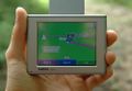
Brett's GPS showing his arrival
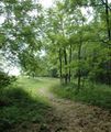
The path leading to the coordinates. The exact point is located where the trail splits
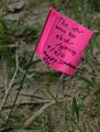
The flag marking the coordinates
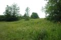
The meadow near the coordinates
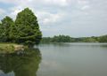
Dawson Lake


