Difference between revisions of "2008-06-20 55 12"
From Geohashing
imported>Thomcat (Success/failure category added) |
imported>ReletBot m (Failed => Not reached) |
||
| Line 25: | Line 25: | ||
[[Category:Expeditions with photos]] | [[Category:Expeditions with photos]] | ||
[[Category:Coordinates not reached]] | [[Category:Coordinates not reached]] | ||
| − | [[Category: | + | [[Category:Not reached - No public access]] |
[[Category:Expedition without GPS]] | [[Category:Expedition without GPS]] | ||
Revision as of 20:29, 31 March 2009
| Fri 20 Jun 2008 in Copenhagen: 55.8812831, 12.0866544 geohashing.info google osm bing/os kml crox |
Expeditions
 Hash: 55.881283082188, 12.0866543637585
Nearest town: Sigerslevvester
Surroundings: Cultivated field - inaccessible
Navigation: Google maps, visual, no GPS
Participants: j0e
Closest distance: Approx. 200m
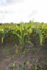
First expedition. It was a beautiful day, so I went there despite inaccessible surroundings and no GPS. I was rewarded with some pictures of a maize field (wow!) :-)
Borrowed an old, yellow, better-than-nothing Garmin etrex the next day (a.k.a. "Old Yeller"). --j0e