Difference between revisions of "2021-11-05 62 29"
(Created page with "{{Subst:Expedition}}") |
|||
| Line 1: | Line 1: | ||
| − | + | {{meetup graticule | |
| − | |||
| − | |||
| − | |||
| − | |||
| − | |||
| − | |||
| − | |||
| − | |||
| lat={{#explode:{{SUBPAGENAME}}| |1}} | | lat={{#explode:{{SUBPAGENAME}}| |1}} | ||
| lon={{#explode:{{SUBPAGENAME}}| |2}} | | lon={{#explode:{{SUBPAGENAME}}| |2}} | ||
| date={{#explode:{{SUBPAGENAME}}| |0}} | | date={{#explode:{{SUBPAGENAME}}| |0}} | ||
| − | }} | + | }} |
__NOTOC__ | __NOTOC__ | ||
== Location == | == Location == | ||
| − | + | In a forest at the edge of Jaamankangas boreal forest, about 30 metres off the nearest road. | |
| + | |||
| + | The point on a topographic map: {{MapSiteLink | N = 6954099 | E = 643319 | title = Geohash+2021-11-05+62+29}} | ||
== Participants == | == Participants == | ||
| − | + | * [[User:Kripakko|Kripakko]] | |
| − | |||
| − | == | + | == Expedition == |
| − | + | At last, I got an easily reachable hashpoint on a day when I had time to go geohashing. I still had much stuff to do during the day and could try to reach this only in the late evening. It was cloudy, raining ever so slightly, and the temperature was +3 °C, so not ideal, but I had no problem going cycling. I ended up cutting it quite close, leaving from home at quarter past eleven and reaching the hashpoint at ten to twelve. When I had taken my time finding the precise spot of the geohash and setting up my camera, the clock had already ticked to 23:58, and I got ready for capturing the proof. Done! I took a few more photos, walked back to the bicycle and cycled back home. I stopped in a few places to take more photos. | |
| − | + | I took my pocket camera and a tripod with me so that I could take photos in the dark. Or so I thought. In the near-total darkness, there was not enough ambient light for any kind of photography, so I had to use the flash, with which the tripod was needless. I could still get much better photos than with my crappy mobile phone camera though, even in places where the was artificial ambient light. I especially liked the photos of the views to the lit highway. | |
| − | + | ||
| + | Cycling in the dark was surprisingly difficult. All street lights in the urban area of Lehmo were turned off, so I had to watch the road with only my bicycle lamp which is not very bright. Even though I knew the route very well, some places took me by surprise when I could not see all the little bumps, dips, cracks, curves and puddles on the surface before driving into them. At least I could trust that there would be nothing particularly dangerous blocking the way, and there was not. Nothing really interesting happened. | ||
| − | + | My GPS receiver was not recording, so I estimated using the topographic map that I had cycled 20.3 km and walked at least 70 m. I also noticed that my camera was still in daylight saving time, so the timestamps of the images, except for the selfie, are off by an hour. The time displayed by the GPS receiver is correct. | |
| − | |||
== Photos == | == Photos == | ||
| − | |||
| − | |||
| − | |||
<gallery perrow="5"> | <gallery perrow="5"> | ||
| + | Image:2021-11-05_62_29_01-gpsr1.jpg | Proof of location. | ||
| + | Image:2021-11-05_62_29_02-gpsr2.jpg | Proof of date and time, just before midnight. | ||
| + | Image:2021-11-05_62_29_03-selfie.jpg | Attempt at a selfie with the mobile phone camera. You can see my face and the lights of highway 6 in the background. | ||
| + | Image:2021-11-05_62_29_04-forest.jpg | How the forest looked like: some pine saplings and tall pines that are just barely visible in the photo. | ||
| + | Image:2021-11-05_62_29_05-lingonberries.jpg | Delicious lingon­berries, some spoilt (watery) bilberries and reindeer lichen. | ||
| + | Image:2021-11-05_62_29_06-bicycle.jpg | Where I left the bicycle, 35 metres to the geohash. | ||
| + | Image:2021-11-05_62_29_07-road1.jpg | Highway 6 photo­graphed at {{MapSiteLink | N = 6953480 | E = 643223 | title = Photo+7}} towards the north. | ||
| + | Image:2021-11-05_62_29_08-road2.jpg | Highway 6 photo­graphed at {{MapSiteLink | N = 6952357 | E = 642933 | title = Photo+8}} towards the south. | ||
| + | Image:2021-11-05_62_29_09-construction.jpg | Construction of a new building where [[2019-04-27 62 29]] was. I do not know what it is. | ||
</gallery> | </gallery> | ||
== Achievements == | == Achievements == | ||
{{#vardefine:ribbonwidth|800px}} | {{#vardefine:ribbonwidth|800px}} | ||
| − | |||
| − | |||
| − | |||
| − | |||
| − | |||
| − | |||
| − | |||
| − | |||
| − | |||
| − | |||
| − | |||
| − | |||
| − | + | {{land geohash | name = Kripakko | latitude = 62 | longitude = 29 | date = 2021-11-05}} | |
| + | {{bicycle geohash | name = Kripakko | latitude = 62 | longitude = 29 | date = 2021-11-05 | distance = 20.3 km | bothways = true}} | ||
| + | {{midnight geohash | name = Kripakko | latitude = 62 | longitude = 29 | date = 2021-11-05}} | ||
| − | |||
[[Category:Expeditions]] | [[Category:Expeditions]] | ||
| − | |||
[[Category:Expeditions with photos]] | [[Category:Expeditions with photos]] | ||
| − | |||
| − | |||
| − | |||
| − | |||
| − | |||
[[Category:Coordinates reached]] | [[Category:Coordinates reached]] | ||
| − | |||
| − | |||
| − | |||
| − | |||
| − | |||
| − | |||
| − | |||
| − | |||
| − | |||
| − | |||
| − | |||
| − | |||
| − | |||
| − | |||
| − | |||
| − | |||
| − | |||
| − | |||
Revision as of 01:08, 6 November 2021
| Fri 5 Nov 2021 in 62,29: 62.6894176, 29.8003866 geohashing.info google osm bing/os kml crox |
Location
In a forest at the edge of Jaamankangas boreal forest, about 30 metres off the nearest road.
The point on a topographic map: [3]
Participants
Expedition
At last, I got an easily reachable hashpoint on a day when I had time to go geohashing. I still had much stuff to do during the day and could try to reach this only in the late evening. It was cloudy, raining ever so slightly, and the temperature was +3 °C, so not ideal, but I had no problem going cycling. I ended up cutting it quite close, leaving from home at quarter past eleven and reaching the hashpoint at ten to twelve. When I had taken my time finding the precise spot of the geohash and setting up my camera, the clock had already ticked to 23:58, and I got ready for capturing the proof. Done! I took a few more photos, walked back to the bicycle and cycled back home. I stopped in a few places to take more photos.
I took my pocket camera and a tripod with me so that I could take photos in the dark. Or so I thought. In the near-total darkness, there was not enough ambient light for any kind of photography, so I had to use the flash, with which the tripod was needless. I could still get much better photos than with my crappy mobile phone camera though, even in places where the was artificial ambient light. I especially liked the photos of the views to the lit highway.
Cycling in the dark was surprisingly difficult. All street lights in the urban area of Lehmo were turned off, so I had to watch the road with only my bicycle lamp which is not very bright. Even though I knew the route very well, some places took me by surprise when I could not see all the little bumps, dips, cracks, curves and puddles on the surface before driving into them. At least I could trust that there would be nothing particularly dangerous blocking the way, and there was not. Nothing really interesting happened.
My GPS receiver was not recording, so I estimated using the topographic map that I had cycled 20.3 km and walked at least 70 m. I also noticed that my camera was still in daylight saving time, so the timestamps of the images, except for the selfie, are off by an hour. The time displayed by the GPS receiver is correct.
Photos
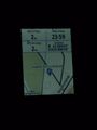
Proof of location.
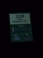
Proof of date and time, just before midnight.
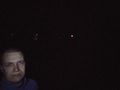
Attempt at a selfie with the mobile phone camera. You can see my face and the lights of highway 6 in the background.
How the forest looked like: some pine saplings and tall pines that are just barely visible in the photo.
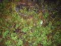
Delicious lingonberries, some spoilt (watery) bilberries and reindeer lichen.
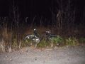
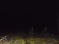
Where I left the bicycle, 35 metres to the geohash.
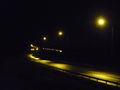
Highway 6 photographed at [1] towards the north.
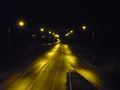
Highway 6 photographed at [2] towards the south.
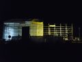
Construction of a new building where 2019-04-27 62 29 was. I do not know what it is.


Achievements
Kripakko earned the Land geohash achievement
|
Kripakko earned the Bicycle geohash achievement
|
Kripakko earned the Midnight Geohash achievement
|