Difference between revisions of "2021-12-19 -37 144"
Felix Dance (talk | contribs) m (→Expedition - Felix Dance) |
Felix Dance (talk | contribs) m (→Achievements) |
||
| Line 57: | Line 57: | ||
| distance = 38 kms | | distance = 38 kms | ||
| bothways = true | | bothways = true | ||
| − | | image = Geohash 2021-12-19 -37 144 08 Bike | + | | image = Geohash 2021-12-19 -37 144 08 Bike.jpg |
}} | }} | ||
Revision as of 22:12, 19 December 2021
| Sun 19 Dec 2021 in -37,144: -37.7514017, 144.7879404 geohashing.info google osm bing/os kml crox |
Location
In the Iramoo Wildflower Grassland Reserve near St Albans.
Participants
Expedition - Felix Dance
After my family's fake Christmas party I headed off on my road bike west towards the hash. I waited a little while to see if my geohashing companion Lachie would join me (I could see by Google Maps that he was only a few hundred metres from me at my local pub), but he was indisposed.
There was a bit of a head wind but it was fairly easy riding to reach St Albans near the hash. The main issue was that there was a large fence surrounding the reserve where the hash was located. The fence was over 2m tall, with another diamond-pattern strip of mesh secured horizontally at the top to make climbing over very difficult. Beyond that there was an electric wire at height to zap anyone who managed to succeed.
So I rode the perimeter looking for weaknesses. The first was in a suburban area, where the cyclone fence strip at the top plus the electric wire was discontinued to allow a gate. There were a lot of people about so I gave this one a miss.
On on the opposite side of the reserve, about 500m away from the hash, there was another gate. This gate also had the advantage that a separate layer of mesh placed between the gate leaves was only latched on with little hooks and could be peeled back. I left my bike here and made a tentative climb to the top.
Unfortunately, my rainjacket, Up&Go and beer (to drink with Lachie in case he turned up) were sticking out of my jersey too far and wouldn't let me through. So I took these out and left them on the ground next to my bike. This allowed me to scale up to the top of the fence and fit between the small gap there afforded. I leapt to the ground and made a steady jog for the hash along 4WD tracks.
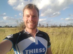
The last section had me leap over a small fence dividing different areas of high grass, no doubt to protect the hash from rabbits and foxes. I reached the point, took a GPS screenshot and some photos of my surrounds. I had been thinking for a while that I wouldn't make this one so I felt not a little triumphant.
I jogged back, clambered over the fence, discovered my unlocked bike hadn't been stolen and rode home. I took a northern route this time, through partially-built housing estates boasting cheek-by-jowel townhouses with zero yard area, along high-voltage-power-line easements and then onto the Ring Road bike path, which took me the Calder Freeway bike path and then down Keilor Road to home. Anyway, you can see it all on my tracklog below.
I arrived home after about 2 hours of geohashing, but, despite a hash-well-done, decided not to join Lachie at the pub.
Tracklog
Photos
Achievements
Felix Dance earned the Bicycle geohash achievement
|


