Difference between revisions of "2020-10-31 34 -118"
From Geohashing
(Completing report) |
(→Expedition) |
||
| (4 intermediate revisions by 3 users not shown) | |||
| Line 1: | Line 1: | ||
| − | <!-- If you did not specify these parameters in the template, please substitute appropriate values for IMAGE, LAT, LON, and DATE (YYYY-MM-DD format) | + | {{ Advert | image = PXL 20201031 233846502.jpg }} |
| − | + | <!-- If you did not specify these parameters in the template, please substitute appropriate values for IMAGE, LAT, LON, and DATE (YYYY-MM-DD format) --> | |
| − | |||
| + | [[Image:{{{image|PXL 20201031 233727592.jpg}}}|thumb|left]] | ||
| + | <!-- | ||
Remove this section if you don't want an image at the top (left) of your report. You should remove the "Image:" or "File:" | Remove this section if you don't want an image at the top (left) of your report. You should remove the "Image:" or "File:" | ||
tag from your image file name, and replace the all upper-case word IMAGE in the above line. | tag from your image file name, and replace the all upper-case word IMAGE in the above line. | ||
| Line 29: | Line 30: | ||
== Expedition == | == Expedition == | ||
<!-- how it all turned out. your narrative goes here. --> | <!-- how it all turned out. your narrative goes here. --> | ||
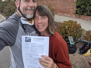
| − | We biked south from Pasadena to the hashpoint and arrived just after our planned time. We stopped for photos and then continued a bicycling tour, including a run to the cemetery where Eleanor was interred after her 103 years on earth. | + | We biked south from Pasadena to the hashpoint and arrived just after our planned time. We stopped for photos and then continued a bicycling tour, including a run to the cemetery where Eleanor was interred after her 103 years on earth. [[User:Bravissimo594|Bravissimo594]] ([[User talk:Bravissimo594|talk]]) |
| − | |||
| − | |||
== Photos == | == Photos == | ||
| Line 39: | Line 38: | ||
<gallery perrow="5"> | <gallery perrow="5"> | ||
Image:Screenshot_20201031-163646.png | On the spot | Image:Screenshot_20201031-163646.png | On the spot | ||
| − | |||
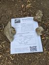
Image:PXL_20201031_233846502.jpg | Marker left behind | Image:PXL_20201031_233846502.jpg | Marker left behind | ||
</gallery> | </gallery> | ||
| Line 46: | Line 44: | ||
{{#vardefine:ribbonwidth|800px}} | {{#vardefine:ribbonwidth|800px}} | ||
<!-- Add any achievement ribbons you earned below, or remove this section --> | <!-- Add any achievement ribbons you earned below, or remove this section --> | ||
| − | |||
| − | |||
| − | |||
| − | |||
| − | |||
| − | |||
| − | |||
| − | |||
| − | |||
| − | |||
| − | |||
| − | |||
| − | |||
[[Category:Expeditions]] | [[Category:Expeditions]] | ||
[[Category:Expeditions with photos]] | [[Category:Expeditions with photos]] | ||
| − | |||
[[Category:Coordinates reached]] | [[Category:Coordinates reached]] | ||
| − | + | {{location|US|CA|LO}} | |
| − | |||
| − | |||
| − | |||
| − | |||
| − | |||
| − | |||
| − | |||
| − | |||
| − | |||
| − | |||
| − | |||
| − | |||
| − | |||
| − | |||
| − | |||
| − | |||
Latest revision as of 05:36, 3 January 2022
| Have you seen our geohashing marker? We'd love to hear from you! Click here to say "hi" and tell us what you've seen!
Curious about what geohashing is? Read more! |  |
| Sat 31 Oct 2020 in 34,-118: 34.0677525, -118.1385057 geohashing.info google osm bing/os kml crox |
Location
Curbside in Alhambra, CA. Nearby address is 1766 Midwickhill Dr. 91803.
See Google Maps link.
Participants
Plans
Bravissimo594 (talk) and Boppy5 plan to bicycle from Pasadena to the hashpoint, hoping to arrive between 4:00 pm and 4:30 pm.
Expedition
We biked south from Pasadena to the hashpoint and arrived just after our planned time. We stopped for photos and then continued a bicycling tour, including a run to the cemetery where Eleanor was interred after her 103 years on earth. Bravissimo594 (talk)


