Difference between revisions of "2022-02-12 -37 144"
Felix Dance (talk | contribs) ([live picture]Neptune!) |
Felix Dance (talk | contribs) (Added 2022 expedition) |
||
| Line 1: | Line 1: | ||
| − | + | [[Image:{{{image|2022-02-12_-37_144_Felix Dance_1644621815425.jpg}}}|thumb|left]] | |
| − | + | {{meetup graticule | |
| − | |||
| − | |||
| − | |||
| − | |||
| − | |||
| − | |||
| lat=-37 | | lat=-37 | ||
| lon=144 | | lon=144 | ||
| date=2022-02-12 | | date=2022-02-12 | ||
| − | }} | + | }} |
| + | |||
__NOTOC__ | __NOTOC__ | ||
== Location == | == Location == | ||
| − | + | On the corner of a brick building in South Warf. | |
== Participants == | == Participants == | ||
| − | + | *[[User:Felix Dance|Felix Dance]] | |
| − | + | *Ruth | |
| + | |||
| + | == Expedition == | ||
| + | I'd hit a 4 geohash streak so I was very interested to see where the next one would land. And yes! Very close in South Melbourne! | ||
| + | |||
| + | I was going to jaunt off my own in the morning (had a few things on in the afternoon when others were more likely to go down for it), but my girlfriend Ruth expressed interest in a little bike ride. So off we went! | ||
| − | + | The sky was sunny and the weather a perfect temperature. We rode down Moonee Ponds Creek and through the Docklands. We then navigated the annoying streets of Port Melbourne to reach the hash. | |
| − | |||
| − | + | My phone got me to within 1.4m as I rode past so we stopped and walked around a bit to get the best spot. It looked like it was right along the wall of a brick building. Quite possibly the hash point was inside it but it was ambiguous from the satellite photo and the coordinates which jumped around a lot. Eventually I took a screen shot for within about 3m and called it a success. | |
| − | + | ||
| + | We got back on our bikes and rode to the beach, sticking our feet in the balmy water. We watched the Spirit of Tasmania sail across the bay towards Bass Strait, sailing boats framing it in the foreground. | ||
| + | |||
| + | We took bike paths along the way back, passing part of the 1:1 billion scale model of the solar system. I took a photo with me and Neptune. | ||
| + | |||
| + | All-in-all another ideal hash. The hash-gods certainly have been smiling on us lately. | ||
== Tracklog == | == Tracklog == | ||
| − | + | {{tracklog | Geohash 2022-02-12 -37 144 20220212_094218 South Warf.gpx}} | |
== Photos == | == Photos == | ||
| − | |||
| − | |||
| − | |||
<gallery perrow="5"> | <gallery perrow="5"> | ||
| Line 49: | Line 50: | ||
== Achievements == | == Achievements == | ||
| − | {{ | + | {{bicycle geohash |
| − | |||
| − | + | | latitude = -37 | |
| − | + | | longitude = 144 | |
| − | [[ | + | | date = 2022-02-08 |
| + | | name = [[User:Felix Dance|Felix Dance]] | ||
| + | | distance = 65 kms | ||
| + | | bothways = false | ||
| + | | image = 2022-02-12_-37_144_Felix Dance_1644621835831.jpg | ||
| − | + | }} | |
| − | + | {{#vardefine:ribbonwidth|800px}} | |
| − | + | [[Category:New report]] | |
| − | |||
| − | |||
| − | |||
| − | |||
| − | |||
| − | |||
[[Category:Expeditions]] | [[Category:Expeditions]] | ||
| − | |||
[[Category:Expeditions with photos]] | [[Category:Expeditions with photos]] | ||
| − | |||
| − | |||
| − | |||
| − | |||
| − | |||
[[Category:Coordinates reached]] | [[Category:Coordinates reached]] | ||
| − | |||
| − | |||
| − | |||
| − | |||
| − | |||
| − | |||
| − | |||
| − | |||
| − | |||
| − | |||
| − | |||
| − | |||
| − | |||
| − | |||
| − | |||
| − | |||
| − | |||
| − | |||
Revision as of 01:26, 12 February 2022

| Sat 12 Feb 2022 in -37,144: -37.8327256, 144.9534468 geohashing.info google osm bing/os kml crox |
Location
On the corner of a brick building in South Warf.
Participants
- Felix Dance
- Ruth
Expedition
I'd hit a 4 geohash streak so I was very interested to see where the next one would land. And yes! Very close in South Melbourne!
I was going to jaunt off my own in the morning (had a few things on in the afternoon when others were more likely to go down for it), but my girlfriend Ruth expressed interest in a little bike ride. So off we went!
The sky was sunny and the weather a perfect temperature. We rode down Moonee Ponds Creek and through the Docklands. We then navigated the annoying streets of Port Melbourne to reach the hash.
My phone got me to within 1.4m as I rode past so we stopped and walked around a bit to get the best spot. It looked like it was right along the wall of a brick building. Quite possibly the hash point was inside it but it was ambiguous from the satellite photo and the coordinates which jumped around a lot. Eventually I took a screen shot for within about 3m and called it a success.
We got back on our bikes and rode to the beach, sticking our feet in the balmy water. We watched the Spirit of Tasmania sail across the bay towards Bass Strait, sailing boats framing it in the foreground.
We took bike paths along the way back, passing part of the 1:1 billion scale model of the solar system. I took a photo with me and Neptune.
All-in-all another ideal hash. The hash-gods certainly have been smiling on us lately.
Tracklog
Photos
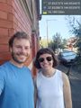
Geohash success! @-37.8329,144.9535
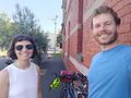
With bikes
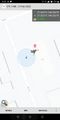
GPS Proof
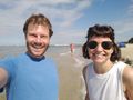
On the beach
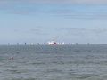
Ships
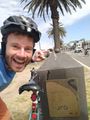
Neptune!


Achievements
Felix Dance earned the Bicycle geohash achievement
|