Difference between revisions of "2022-03-12 36 -112"
Felix Dance (talk | contribs) (Added description) |
Felix Dance (talk | contribs) (→Photos: Added images) |
||
| Line 1: | Line 1: | ||
| − | [[Image:{{{image|.jpg}}}|thumb|left]] | + | [[Image:{{{image|Geohash 2022-03-12 36 -112 01 Felix.jpg}}}|thumb|left]] |
{{meetup graticule | {{meetup graticule | ||
| Line 18: | Line 18: | ||
I'd noticed that the previous day's geohash was right down the bottom of the canyon. No getting that, I thought. | I'd noticed that the previous day's geohash was right down the bottom of the canyon. No getting that, I thought. | ||
| − | The next day we did a day-hike, along the ridge and down one of the Spurs. We celebrated at the pub near the general store in the afternoon, using their free but extremely spotty wifi (no phone service here). That's when I saw it. It was 4pm and the geohash was | + | The next day we did a day-hike, along the ridge and down one of the Spurs. We celebrated at the pub near the general store in the afternoon, using their free but extremely spotty wifi (no phone service here). That's when I saw it. It was 4pm and the geohash was 9kms away. The internet wasn't good enough to properly resolve the location but.... it looked like it was right on the ridge of the canyon. Maybe a little over. This was a big deal. |
| − | My ever-supportive gf was on board, knowing my enthusiastic love of geohashing. She would wait in the car of course. I saved enough details of the location to get me there on my phone and we drove off in our little van. | + | My ever-supportive gf was on board, knowing my enthusiastic love of geohashing. She would wait in the car, of course. I saved enough details of the location to get me there on my phone and we drove off in our little van. |
| − | I parked beside the road in the snow near the hash and ran into the bush. The snow was about | + | I parked beside the road in the snow near the hash and ran into the bush. The snow was about 2-4cms deep and I could see elk-hoof prints crazing the surface. The distance ticked down from 800m to 500m to 250m. I was nearly there. |
| − | Suddenly, the forest gave way to a massive drop. The undulating canyon walls opposite reared into view. Glad I was watching my step. | + | Suddenly, the forest gave way to a massive drop. The vast, undulating canyon walls opposite reared into view. Glad I was watching my step. |
| − | My GPS was at 20m, with about 2m to the drop. But the direction was a bit to the left. I changed direction and followed the ridge. 14m. 8m. 5m. The ledge started jutting out in the direction of the hash. I took screen shots with a sub- | + | My GPS was at 20m, with about 2m to the drop-off. But the direction was a bit to the left. I changed direction and followed the ridge. 14m. 8m. 5m. The ledge started jutting out in the direction of the hash. I took screen shots with a sub-one metre distance. Literally right on the edge of the canyon. One foot on the ridge, the other using a rock to brace against the rapidly steepening snow slope to doom. I'd made it. |
| − | I wanted to take some | + | I wanted to take some decent shots of this unbelievable view but my good camera chose this moment to die of battery fatigue. But my phone camera was serviceable and that's what I used. In a few minutes I was back in the forest, wary of the drop next to me, and legging it back to the car in time to get to the agreed lookout to watch the sunset. Half an hour, the trip took me. |
| − | Apart from getting the car bogged in the snow and having to push it out in full, embarrassing view of passing traffic the drive back was uneventful. | + | Apart from getting the car bogged in the snow and having to push it out in full, embarrassing view of passing traffic the drive back was uneventful. Notwithstanding, of course, my unparalleled chuffedness of the geohash location and the favour bestowed upon me for being able to reach it. |
== Photos == | == Photos == | ||
| Line 37: | Line 37: | ||
--> | --> | ||
<gallery perrow="5"> | <gallery perrow="5"> | ||
| − | + | Geohash 2022-03-12 36 -112 01 Felix.jpg|Me at the hash | |
| − | + | Geohash 2022-03-12 36 -112 02 View 1.jpg|View 1 | |
| + | Geohash 2022-03-12 36 -112 03 View 2.jpg|View 2 | ||
| + | Geohash 2022-03-12 36 -112 04 Ledge.jpg|Hash location | ||
| + | Geohash 2022-03-12 36 -112 05 Ledge 2.jpg|The ledge | ||
| + | Geohash 2022-03-12 36 -112 06 Canyon.jpg|Canyon | ||
| + | Geohash 2022-03-12 36 -112 07 Pano.jpg|hash-panorama | ||
| + | Geohash 2022-03-12 36 -112 08 Route.jpg|The route back | ||
| + | Geohash 2022-03-12 36 -112 09 GPS.jpg|GPS proof | ||
| + | Geohash 2022-03-12 36 -112 10 Location.jpg|Location form starting point | ||
| + | Geohash 2022-03-12 36 -112 11 Detailed location.jpg|Detailed terrain view | ||
| + | Geohash 2022-03-12 36 -112 03 Sat.jpg|Satellite view | ||
</gallery> | </gallery> | ||
Revision as of 22:24, 13 March 2022

| Sat 12 Mar 2022 in 36,-112: 36.0093955, -112.0391185 geohashing.info google osm bing/os kml crox |
Location
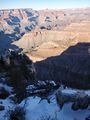
Very amazing: right on a ledge at the South rim of the Grand Canyon.
Participants
Expedition
This was pretty unbelievable. My girlfriend and I, from Australia, have been travelling around the southwest US states in a campervan and we'd reached the Grand Canyon - a classic tourist destination for people like us.
I'd noticed that the previous day's geohash was right down the bottom of the canyon. No getting that, I thought.
The next day we did a day-hike, along the ridge and down one of the Spurs. We celebrated at the pub near the general store in the afternoon, using their free but extremely spotty wifi (no phone service here). That's when I saw it. It was 4pm and the geohash was 9kms away. The internet wasn't good enough to properly resolve the location but.... it looked like it was right on the ridge of the canyon. Maybe a little over. This was a big deal.
My ever-supportive gf was on board, knowing my enthusiastic love of geohashing. She would wait in the car, of course. I saved enough details of the location to get me there on my phone and we drove off in our little van.
I parked beside the road in the snow near the hash and ran into the bush. The snow was about 2-4cms deep and I could see elk-hoof prints crazing the surface. The distance ticked down from 800m to 500m to 250m. I was nearly there.
Suddenly, the forest gave way to a massive drop. The vast, undulating canyon walls opposite reared into view. Glad I was watching my step.
My GPS was at 20m, with about 2m to the drop-off. But the direction was a bit to the left. I changed direction and followed the ridge. 14m. 8m. 5m. The ledge started jutting out in the direction of the hash. I took screen shots with a sub-one metre distance. Literally right on the edge of the canyon. One foot on the ridge, the other using a rock to brace against the rapidly steepening snow slope to doom. I'd made it.
I wanted to take some decent shots of this unbelievable view but my good camera chose this moment to die of battery fatigue. But my phone camera was serviceable and that's what I used. In a few minutes I was back in the forest, wary of the drop next to me, and legging it back to the car in time to get to the agreed lookout to watch the sunset. Half an hour, the trip took me.
Apart from getting the car bogged in the snow and having to push it out in full, embarrassing view of passing traffic the drive back was uneventful. Notwithstanding, of course, my unparalleled chuffedness of the geohash location and the favour bestowed upon me for being able to reach it.
Photos

Me at the hash
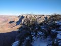
View 1
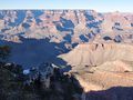
View 2
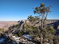
Hash location
The ledge
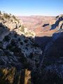
Canyon

hash-panorama
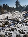
The route back
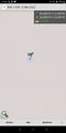
GPS proof
Location form starting point
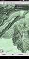
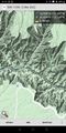
Detailed terrain view
- Geohash 2022-03-12 36 -112 03 Sat.jpg
Satellite view


Achievements
Felix Dance earned the Globetrotter achievement
|