Difference between revisions of "2011-12-24 55 13"
imported>Fasanen |
m |
||
| (7 intermediate revisions by 4 users not shown) | |||
| Line 1: | Line 1: | ||
| − | |||
| − | |||
| − | |||
| − | |||
| − | |||
| − | |||
| − | |||
| − | |||
| − | |||
{{meetup graticule | {{meetup graticule | ||
| lat=55 | | lat=55 | ||
| Line 14: | Line 5: | ||
}} | }} | ||
| − | |||
__NOTOC__ | __NOTOC__ | ||
== Location == | == Location == | ||
| − | Field just outside Dalby. | + | Field just outside Dalby, [[wikipedia:Skåne|Skåne]], [[wikipedia:Sweden|Sweden]]. |
== Participants == | == Participants == | ||
| − | + | * [[User:Llavids|Llavids]] | |
| + | * [[User:Fasanen|Fasanen]] | ||
| − | == Plans == | + | == Llavids Plans == |
| − | + | Thought of driving by when going to celebrate Christmas just outside Trelleborg, but we didn't have the time when we finally left the house. | |
| − | == Expedition == | + | == Llavids Expedition == |
| − | + | Thought it was a failed day, but since Christmas presents and food went short and everybody was a bit tired, we all drove home early, which meant that if we took the fast road to Dalby we would made it just in time for a midnight geohashe on Christmas. The time planning was indeed correct and we parked the car as close as possible. Maybe in daytime this would have been a very muddy field, but now this late the ground was a bit frozen, and when I was so close to target I just stepped out into the field only to realize it was hard enough to walk on. Quickly found the geohashe location and took a picture, but forgot to turn off the flash. Second picture just a minute late of midnight. Took some crappy pictures of myself and the surroundings before driving home with the family again. Success! | |
| − | == | + | == Fasanen's Expedition == |
| − | + | I was driving to Halmstad in the morning to celebrate Christmas and the hash location was on the way. Before leaving I checked the Google maps satellite images and it pointed out a field. It was quite rainy and I had not much hope of reaching the hash as I expected the ground to be very muddy, but I gave it a shot anyway. I came as close as 20 meters from the hash but did not bother to get any closer. I did not want to meet Santa covered up to my ears in mud, so I took some uninteresting photographs and continued my journey to Halmstad. This was my last expedition in 2011. | |
| − | == Photos == | + | == Llavids Photos == |
| − | |||
| − | |||
| − | |||
<gallery perrow="5"> | <gallery perrow="5"> | ||
| + | Image:20111224-55-13-01-Proof.JPG | First proof, midnight | ||
| + | Image:20111224-55-13-02-Proof-late.JPG | Proof, just a bit later | ||
| + | Image:20111224-55-13-03-The-grin.JPG | The grin | ||
| + | Image:20111224-55-13-04-The-distance.JPG | The distance into the field | ||
| + | Image:20111224-55-13-05-East.JPG | East (Dalby) | ||
| + | Image:20111224-55-13-06-City-lights.JPG | City lights (Lund) | ||
| + | Image:20111224-55-13-07-Opposite.JPG | Opposite the road, out into the field on the other side of the car | ||
</gallery> | </gallery> | ||
| − | == Achievements == | + | == Llavids Achievements == |
{{#vardefine:ribbonwidth|800px}} | {{#vardefine:ribbonwidth|800px}} | ||
| − | |||
| + | {{Land geohash | ||
| + | | latitude = 55 | ||
| + | | longitude = 13 | ||
| + | | name=[[User:Llavids|Llavids]] | ||
| + | | date = 2011-12-24 | ||
| + | }} | ||
| − | + | {{Midnight geohash | |
| − | + | | latitude = 55 | |
| − | [[ | + | | longitude = 13 |
| + | | date = 2011-12-24 | ||
| + | | name = [[User:Llavids|Llavids]] | ||
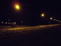
| + | | image = 20111224-55-13-04-The-distance.JPG | ||
| + | }} | ||
| + | |||
| + | * MNB? | ||
| − | |||
| − | |||
| − | |||
| − | |||
| − | |||
| − | |||
[[Category:Expeditions]] | [[Category:Expeditions]] | ||
| − | |||
[[Category:Expeditions with photos]] | [[Category:Expeditions with photos]] | ||
| − | + | ||
| − | |||
| − | |||
| − | |||
| − | |||
[[Category:Coordinates reached]] | [[Category:Coordinates reached]] | ||
| − | |||
| − | <!-- | + | <!--[[Category:Coordinates not reached]] |
| − | [[Category:Coordinates not reached]] | + | [[Category:Not reached - Mother Nature]]--> |
| − | + | ||
| − | [[Category:Not reached - Mother Nature]] | + | [[Category:Sweden]] |
| − | + | {{location|SE|M}} | |
| − | [[Category: | ||
| − | |||
| − | |||
Latest revision as of 09:26, 16 March 2022
| Sat 24 Dec 2011 in 55,13: 55.6664341, 13.3375469 geohashing.info google osm bing/os kml crox |
Location
Field just outside Dalby, Skåne, Sweden.
Participants
Llavids Plans
Thought of driving by when going to celebrate Christmas just outside Trelleborg, but we didn't have the time when we finally left the house.
Llavids Expedition
Thought it was a failed day, but since Christmas presents and food went short and everybody was a bit tired, we all drove home early, which meant that if we took the fast road to Dalby we would made it just in time for a midnight geohashe on Christmas. The time planning was indeed correct and we parked the car as close as possible. Maybe in daytime this would have been a very muddy field, but now this late the ground was a bit frozen, and when I was so close to target I just stepped out into the field only to realize it was hard enough to walk on. Quickly found the geohashe location and took a picture, but forgot to turn off the flash. Second picture just a minute late of midnight. Took some crappy pictures of myself and the surroundings before driving home with the family again. Success!
Fasanen's Expedition
I was driving to Halmstad in the morning to celebrate Christmas and the hash location was on the way. Before leaving I checked the Google maps satellite images and it pointed out a field. It was quite rainy and I had not much hope of reaching the hash as I expected the ground to be very muddy, but I gave it a shot anyway. I came as close as 20 meters from the hash but did not bother to get any closer. I did not want to meet Santa covered up to my ears in mud, so I took some uninteresting photographs and continued my journey to Halmstad. This was my last expedition in 2011.
Llavids Photos
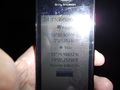
First proof, midnight
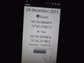
Proof, just a bit later

The grin
The distance into the field
East (Dalby)
City lights (Lund)
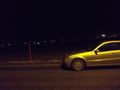
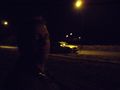
Opposite the road, out into the field on the other side of the car


Llavids Achievements
Llavids earned the Land geohash achievement
|
Llavids earned the Midnight Geohash achievement
|
- MNB?