Difference between revisions of "2014-04-08 48 8"
From Geohashing
imported>RecentlyChanged (→Tracklog) |
m |
||
| (10 intermediate revisions by 4 users not shown) | |||
| Line 18: | Line 18: | ||
__NOTOC__ | __NOTOC__ | ||
== Location == | == Location == | ||
| − | + | A field! Awesome! | |
== Participants == | == Participants == | ||
| − | + | *[[User:RecentlyChanged|RecentlyChanged]] | |
| − | + | == Plans == | |
| − | == | + | *I will go there tomorrow, without GPS, with motorbike. -- RecentlyChanged [http://www.openstreetmap.org/?lat=48.14157420&lon=8.19961110&zoom=16&layers=B000FTF @48.1416,8.1996] 21:35, 7 April 2014 (CEST) |
| − | |||
== Expedition == | == Expedition == | ||
| − | |||
| − | * | + | *It all begins! -- RecentlyChanged [http://www.openstreetmap.org/?lat=48.14166069&lon=8.19964170&zoom=16&layers=B000FTF @48.1417,8.1996] 16:53, 8 April 2014 (CEST) |
| + | |||
| + | |||
| + | As you maybe guessed, I tried the Hashdroid for the first time for posting things and I like it. | ||
| + | |||
| + | I had to organize a few things so I were near the Hash anyway. Unluckily the weather was cold, so I could not take the motorbike :( | ||
| − | |||
== Tracklog == | == Tracklog == | ||
http://www.everytrail.com/view_trip.php?trip_id=2730509 | http://www.everytrail.com/view_trip.php?trip_id=2730509 | ||
| Line 42: | Line 44: | ||
--> | --> | ||
<gallery perrow="5"> | <gallery perrow="5"> | ||
| + | |||
| + | Image:2014-04-08_48_8_RecentlyChanged_1396972280000.jpg | I forgot the stupid grin :( | ||
| + | |||
| + | Image:2014-04-08_48_8_RecentlyChanged_1396972285000.jpg | View from the hashpoint | ||
</gallery> | </gallery> | ||
| Line 48: | Line 54: | ||
<!-- Add any achievement ribbons you earned below, or remove this section --> | <!-- Add any achievement ribbons you earned below, or remove this section --> | ||
| + | {{land geohash | ||
| − | + | | latitude = 48 | |
| − | + | | longitude = 8 | |
| − | + | | date = 2014-04-08 | |
| + | | name = RecentlyChanged | ||
| − | + | }} | |
| − | |||
| − | |||
| − | |||
| − | |||
| − | |||
| − | |||
[[Category:Expeditions]] | [[Category:Expeditions]] | ||
| − | |||
[[Category:Expeditions with photos]] | [[Category:Expeditions with photos]] | ||
| − | + | ||
| − | |||
| − | |||
| − | |||
| − | |||
[[Category:Coordinates reached]] | [[Category:Coordinates reached]] | ||
| − | + | {{location|DE|BW|VS}} | |
| − | |||
| − | |||
| − | |||
| − | |||
| − | |||
| − | |||
| − | |||
| − | |||
| − | |||
| − | |||
| − | |||
| − | |||
| − | |||
| − | |||
| − | |||
| − | |||
| − | |||
Latest revision as of 16:04, 18 March 2022
| Tue 8 Apr 2014 in 48,8: 48.0677724, 8.3283539 geohashing.info google osm bing/os kml crox |
Location
A field! Awesome!
Participants
Plans
- I will go there tomorrow, without GPS, with motorbike. -- RecentlyChanged @48.1416,8.1996 21:35, 7 April 2014 (CEST)
Expedition
- It all begins! -- RecentlyChanged @48.1417,8.1996 16:53, 8 April 2014 (CEST)
As you maybe guessed, I tried the Hashdroid for the first time for posting things and I like it.
I had to organize a few things so I were near the Hash anyway. Unluckily the weather was cold, so I could not take the motorbike :(
Tracklog
http://www.everytrail.com/view_trip.php?trip_id=2730509
Photos
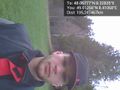
I forgot the stupid grin :(
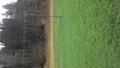
View from the hashpoint


Achievements
RecentlyChanged earned the Land geohash achievement
|