Difference between revisions of "2008-06-27 42 -83"
From Geohashing
imported>Billsquared (New page: {{meetup graticule | map=<map lat="42" lon="-83" date="2008-06-27" /> | lat=42 | lon=-83 | date=2008-06-27 }} == About == This location is in the middle of a front yard (of what I think ...) |
m |
||
| (5 intermediate revisions by 3 users not shown) | |||
| Line 12: | Line 12: | ||
== Plan == | == Plan == | ||
| − | '''Bill^2:''' I'm going to try to make this location on my afternoon bike ride. I should be there some time between 5-6pm. If anyone else plans on trying to make it, please post details so we can synchronize timing. | + | '''[[User:Billsquared|Bill^2]]:''' I'm going to try to make this location on my afternoon bike ride. I should be there some time between 5-6pm. If anyone else plans on trying to make it, please post details so we can synchronize timing. |
| + | |||
| + | == Pictures == | ||
| + | |||
| + | I showed up about 5:30 and scoped out the site. Nobody appeared to be home at the residence, so I navigated to the hash location, snapped my pictures, and departed. (I have pictures of a slightly more accurate GPS fix, but they're nearly too blurry to read.) | ||
| + | |||
| + | <gallery> | ||
| + | Image:2008-06-27_42_-83_Bill.jpg | Bill on the curb | ||
| + | Image:2008-06-27_42_-83_GPS.jpg | GPS fix on the hash location | ||
| + | </gallery> | ||
| + | |||
| + | [[Category:Expeditions]] | ||
| + | [[Category:Expeditions with photos]] | ||
| + | [[Category:Coordinates reached]] | ||
| + | {{location|US|MI|OD}} | ||
Latest revision as of 23:04, 18 March 2022
| Fri 27 Jun 2008 in 42,-83: 42.6189459, -83.2306186 geohashing.info google osm bing/os kml crox |
About
This location is in the middle of a front yard (of what I think is a detached condo neighborhood) west of Squirrel Rd, south of South Blvd.
Plan
Bill^2: I'm going to try to make this location on my afternoon bike ride. I should be there some time between 5-6pm. If anyone else plans on trying to make it, please post details so we can synchronize timing.
Pictures
I showed up about 5:30 and scoped out the site. Nobody appeared to be home at the residence, so I navigated to the hash location, snapped my pictures, and departed. (I have pictures of a slightly more accurate GPS fix, but they're nearly too blurry to read.)

Bill on the curb
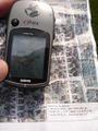
GPS fix on the hash location

