Difference between revisions of "2009-03-17 -36 174"
imported>TunezNZ |
m |
||
| (6 intermediate revisions by 3 users not shown) | |||
| Line 5: | Line 5: | ||
| date=2009-03-17 | | date=2009-03-17 | ||
}} | }} | ||
| − | Tunez spotted the hash and had 90 min's to burn before and appointment so he | + | [[User:TunezNZ|Tunez]] spotted the hash and had 90 min's to burn before and appointment so he went a-hashing. |
| + | |||
==About== | ==About== | ||
| − | Inside a corn field near my old house, I still have access to the adjacent land as we graze stock there. I decided to take a longer but more hidden route that took me along a tree line and well up down and everywhere | + | Inside a corn field near my old house, I still have access to the adjacent land as we graze stock there. I decided to take a longer but more hidden route that took me along a tree line and, well, up, down and everywhere. It took 1350m according to a Google earth measure but due to the ups and downs I would imagine it was a lot longer than that, at least it felt longer. It took 30 mins to get in and another 20 to get out and be on my way. |
| − | |||
| − | + | Nothing that interesting, just a lot of corn and soft dirt. The farm used to host an ostrich breeding and hatching farm; consequently I found a few broken ostrich eggs, I MEAN OBVIOUSLY HATCHED RAPTOR EGGS! (They were 2mm thick.) But it was a nice walk. | |
| − | |||
| − | |||
| − | |||
| + | == Photos == | ||
| + | <gallery widths="160px" align=center perrow="3"> | ||
| + | Image:Auckland 3 17 09 the grin.JPG|The Grin | ||
| + | Image:Auckland 3 17 09 hashmash.JPG|Somewher there is the hash, Probiably under me | ||
| + | Image:Auckland 3 17 09 map and location.JPG|The one mean of knowing where to go | ||
| + | Image:Auckland 3 17 09 walkmap.jpg|This is the trak I took | ||
| + | Image:Auckland 3 17 09 terrain.JPG|The high of the grass vs the 6 foot high corn | ||
| + | Image:Auckland 3 17 09 height of the grass.JPG|And as comparison the grass againts me | ||
| + | Image:Auckland 3 17 09 thatway.JPG|Ok homeward that way! | ||
| + | Image:Auckland 3 17 09 where to treck to.JPG|Aww but the corns so high | ||
| + | Image:Auckland 3 17 09 field.jpg|Another shot of the terrain | ||
| + | Image:Auckland 3 17 09 raptor tracks.JPG|OBVIOUS RAPTOR TRACKS!!! Acutaly these wher reaching towards the hash on my way in (a nonreporting hasher possiably) | ||
</gallery> | </gallery> | ||
| + | |||
[[Category:Expeditions]] | [[Category:Expeditions]] | ||
| Line 21: | Line 31: | ||
[[Category:Coordinates reached]] | [[Category:Coordinates reached]] | ||
[[Category:Expedition without GPS]] | [[Category:Expedition without GPS]] | ||
| + | {{location|NZ|AUK}} | ||
Latest revision as of 13:34, 19 March 2022
| Tue 17 Mar 2009 in -36,174: -36.9794568, 174.9238954 geohashing.info google osm bing/os kml crox |
Tunez spotted the hash and had 90 min's to burn before and appointment so he went a-hashing.
About
Inside a corn field near my old house, I still have access to the adjacent land as we graze stock there. I decided to take a longer but more hidden route that took me along a tree line and, well, up, down and everywhere. It took 1350m according to a Google earth measure but due to the ups and downs I would imagine it was a lot longer than that, at least it felt longer. It took 30 mins to get in and another 20 to get out and be on my way.
Nothing that interesting, just a lot of corn and soft dirt. The farm used to host an ostrich breeding and hatching farm; consequently I found a few broken ostrich eggs, I MEAN OBVIOUSLY HATCHED RAPTOR EGGS! (They were 2mm thick.) But it was a nice walk.
Photos

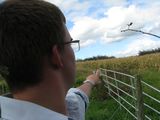
The Grin
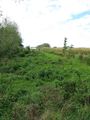
Somewher there is the hash, Probiably under me
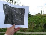
The one mean of knowing where to go
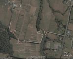
This is the trak I took
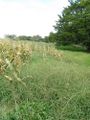
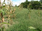
The high of the grass vs the 6 foot high corn

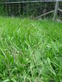
And as comparison the grass againts me
Ok homeward that way!
Aww but the corns so high
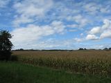
Another shot of the terrain
OBVIOUS RAPTOR TRACKS!!! Acutaly these wher reaching towards the hash on my way in (a nonreporting hasher possiably)


