Difference between revisions of "2009-01-11 31 -111"
From Geohashing
imported>Wyle & RoadRunner (New page: {{meetup graticule | map=<map lat="31" lon="-111" date="2009-01-11" /> | lat=31 | lon=-111 | date=2009-01-11 | graticule_name=Sasabe | graticule_link=Sasabe, Arizona}} == Expeditions == Si...) |
m |
||
| (3 intermediate revisions by 3 users not shown) | |||
| Line 6: | Line 6: | ||
| graticule_name=Sasabe | | graticule_name=Sasabe | ||
| graticule_link=Sasabe, Arizona}} | | graticule_link=Sasabe, Arizona}} | ||
| + | ==Participants== | ||
| + | *[[User:Wyle & RoadRunner|Wyle & RoadRunner]] | ||
== Expeditions == | == Expeditions == | ||
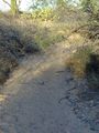
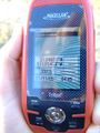
| − | Since our own Casa Grande hash point was way to the north, we decided to skip down to the uncharted Sasabe gradicule which allowed us to drive within 200 feet | + | Since our own Casa Grande hash point was way to the north, we decided to skip down to the uncharted Sasabe gradicule which allowed us to drive within 200 feet of the location. This was rather welcomed after doing a 8 mile hike earlier in the day. Deflowering the gradicule was just a bonus. :) Pic is the landscape at the geohash location. You can see all of RoadRunners footprints as she tried to get all 5 decimal digits on the GPS. She looked like she was creating a new dance step. |
<gallery widths="160px" align=center> | <gallery widths="160px" align=center> | ||
Image:2009-01-11 31 -111 wash.jpg|Sasabe, Arizona | Image:2009-01-11 31 -111 wash.jpg|Sasabe, Arizona | ||
| + | Image:2009-01-11 31 -111 gps.jpg|Sasabe, Arizona | ||
</gallery> | </gallery> | ||
| Line 15: | Line 18: | ||
[[Category:Expeditions with photos]] | [[Category:Expeditions with photos]] | ||
[[Category:Coordinates reached]] | [[Category:Coordinates reached]] | ||
| + | {{location|US|AZ|PM}} | ||
Latest revision as of 17:16, 19 March 2022
| Sun 11 Jan 2009 in Sasabe: 31.9460426, -111.0540563 geohashing.info google osm bing/os kml crox |
Participants
Expeditions
Since our own Casa Grande hash point was way to the north, we decided to skip down to the uncharted Sasabe gradicule which allowed us to drive within 200 feet of the location. This was rather welcomed after doing a 8 mile hike earlier in the day. Deflowering the gradicule was just a bonus. :) Pic is the landscape at the geohash location. You can see all of RoadRunners footprints as she tried to get all 5 decimal digits on the GPS. She looked like she was creating a new dance step.
Sasabe, Arizona
Sasabe, Arizona

