Difference between revisions of "2021-11-19 51 9"
From Geohashing
(Created page with "{{meetup graticule | lat=51 | lon=9 | date=2021-11-19 }} <!-- edit as necessary --> __NOTOC__ == Location == On a field west of Mariengarten == Participants == User:Digi...") |
m |
||
| Line 33: | Line 33: | ||
[[Category:Expeditions with photos]] | [[Category:Expeditions with photos]] | ||
[[Category:Coordinates not reached]] | [[Category:Coordinates not reached]] | ||
| + | [[Category:Not reached - No public access]] | ||
| + | [[Category:Not reached - Mother Nature]] | ||
{{location|DE|NI|GÖ}} | {{location|DE|NI|GÖ}} | ||
Latest revision as of 13:22, 24 March 2022
| Fri 19 Nov 2021 in 51,9: 51.4412777, 9.8514793 geohashing.info google osm bing/os kml crox |
Location
On a field west of Mariengarten
Participants
Plans
Even if I know this one is on a field, I want to give it a try.
Expedition
The geohash was indeed located on a freshly tilled field and I couldn't even get near the hash, since there was no way leading to it. I had considered to walk along a little creek to get as near to the coordinates as possible, but there wasn't a way to get through - thorny bushes all the way long. Tried my luck from both north and south direction, but I simply didn't have a chance here... Tomorrow's hash is only one kilometer from here, in a forest - guess I'll give it a try!
Photos
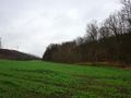
View from south
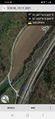
Still 340 meters to go
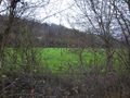
View from north
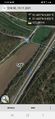
Still 170 meters to go


