Difference between revisions of "2016-05-23 52 1"
From Geohashing
imported>Sourcerer m (→Expedition - Fail) |
m |
||
| (2 intermediate revisions by 2 users not shown) | |||
| Line 37: | Line 37: | ||
| prev = 2016-05-22 52 1 | | prev = 2016-05-22 52 1 | ||
| curr = 2016-05-23 52 1 | | curr = 2016-05-23 52 1 | ||
| − | | next = 2016-05- | + | | next = 2016-05-31 52 -3 |
| date = 2016-05-23 | | date = 2016-05-23 | ||
}} | }} | ||
| Line 44: | Line 44: | ||
[[Category:Expeditions with photos]] | [[Category:Expeditions with photos]] | ||
[[Category:Coordinates not reached]] | [[Category:Coordinates not reached]] | ||
| + | [[Category:Not reached - No public access]] | ||
| + | {{location|GB|ENG|NFK}} | ||
Latest revision as of 11:40, 27 March 2022
| Mon 23 May 2016 in Norwich, UK: 52.4933109, 1.0791717 geohashing.info google osm bing/os kml crox |
Location
A field NW of Upgate Street, Norfolk, UK.
Participants
Plans
Two of two spanning midnight - 2016-05-22 52 1 - 2016-05-23 52 1 - ETA 00:00.
Expedition - Fail
- Foiled. Deep dykes and thick hedges. -- Sourcerer (talk) @52.4927,1.0811 00:08, 23 May 2016 (GMT+01:00)
The first field was ploughed and tilled but no new growth was obvious. 150 metres from the hashpoint there was a deep dyke and a thick hedge blocking access to the final field. The barriers looked well maintained and there was little prospect of finding a gap. The attempt was abandoned.
Photos
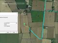
Google Earth Track

Achievements
Expeditions and Plans
| 2016-05-23 | ||
|---|---|---|
| Budapest, Hungary | Nix78 | Somewhere |
| Stuttgart, Germany | Someone went | Bläsiberg, Tübingen |
| Nürnberg, Germany | Schnatterfleck | Somewhere |
| Norwich, United Kingdom | Sourcerer | A field NW of Upgate Street, Norfolk, UK. |
Sourcerer's Expedition Links
2016-05-22 52 1 - 2016-05-23 52 1 - 2016-05-31 52 -3 - KML file download of Sourcerer's expeditions for use with Google Earth.