Difference between revisions of "2022-03-31 68 26"
From Geohashing
(→Location) |
m |
||
| (7 intermediate revisions by 2 users not shown) | |||
| Line 20: | Line 20: | ||
<!-- who attended: If you link to your wiki user name in this section, your expedition will be picked up by the various statistics generated for geohashing. You may use three tildes ~ as a shortcut to automatically insert the user signature of the account you are editing with. | <!-- who attended: If you link to your wiki user name in this section, your expedition will be picked up by the various statistics generated for geohashing. You may use three tildes ~ as a shortcut to automatically insert the user signature of the account you are editing with. | ||
--> | --> | ||
| + | [[User:Bysmyyr|Bysmyyr]] ([[User talk:Bysmyyr|talk]]) | ||
== Plans == | == Plans == | ||
<!-- what were the original plans --> | <!-- what were the original plans --> | ||
| + | Drive there and visit hash and the lake and river. | ||
== Expedition == | == Expedition == | ||
<!-- how it all turned out. your narrative goes here. --> | <!-- how it all turned out. your narrative goes here. --> | ||
| + | |||
| + | After leaving the previous one ride with googlemaps near the hash. When there was 16km to hash, road was full of snow so no going there with car. Alternative rouve was 170km so I skipped that. There was also road closed mark and when I checked where it was closed, it was quite near the hash but the snow was not cleaned because of that and prevented the near access. I thought going that 16km by snowshoes but I am not too good with those currently. Made 10km trip there instead. Nice weather and nature. | ||
== Tracklog == | == Tracklog == | ||
| Line 35: | Line 39: | ||
--> | --> | ||
<gallery perrow="5"> | <gallery perrow="5"> | ||
| + | Image:msg49170418-296238.jpg| The now cleared road | ||
| + | Image:msg49170418-296239.jpg | Animal marks | ||
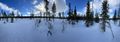
| + | Image:msg49170418-296240.jpg | Lake near | ||
| + | Image:msg49170418-296237.jpg | Blockade | ||
</gallery> | </gallery> | ||
| Line 41: | Line 49: | ||
<!-- Add any achievement ribbons you earned below, or remove this section --> | <!-- Add any achievement ribbons you earned below, or remove this section --> | ||
| − | |||
| − | |||
| − | |||
| − | + | [[Category:Expeditions]] | |
| − | |||
| − | |||
| − | |||
| − | |||
| − | |||
| − | |||
| − | |||
| − | |||
| − | |||
| − | |||
[[Category:Expeditions with photos]] | [[Category:Expeditions with photos]] | ||
| − | |||
| − | |||
| − | |||
| − | |||
| − | |||
| − | |||
| − | |||
[[Category:Coordinates not reached]] | [[Category:Coordinates not reached]] | ||
| − | |||
| − | |||
[[Category:Not reached - Mother Nature]] | [[Category:Not reached - Mother Nature]] | ||
| − | + | {{location|FI|10}} | |
| − | |||
| − | |||
| − | |||
| − | |||
| − | |||
| − | |||
| − | |||
| − | |||
| − | |||
| − | |||
Revision as of 18:25, 31 March 2022
| Thu 31 Mar 2022 in 68,26: 68.0590375, 26.0798594 geohashing.info google osm bing/os kml crox |
Location
Forest near river and lake Järvijärvi (literally translated: Lakelake) Road is quite near.
Participants
Plans
Drive there and visit hash and the lake and river.
Expedition
After leaving the previous one ride with googlemaps near the hash. When there was 16km to hash, road was full of snow so no going there with car. Alternative rouve was 170km so I skipped that. There was also road closed mark and when I checked where it was closed, it was quite near the hash but the snow was not cleaned because of that and prevented the near access. I thought going that 16km by snowshoes but I am not too good with those currently. Made 10km trip there instead. Nice weather and nature.
Tracklog
Photos
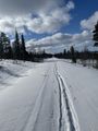
The now cleared road
Animal marks
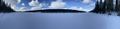
Lake near
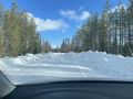
Blockade

