Difference between revisions of "2013-09-17 45 -122"
From Geohashing
imported>Frogman (Created page with "{{subst:Expedition |lat = 45 |lon = -122 |date = 2013-09-17 }}") |
m |
||
| (7 intermediate revisions by 2 users not shown) | |||
| Line 19: | Line 19: | ||
== Location == | == Location == | ||
<!-- where you've surveyed the hash to be --> | <!-- where you've surveyed the hash to be --> | ||
| + | On a Mt. Hood National Forest road near Larch Mountain. | ||
== Participants == | == Participants == | ||
<!-- who attended: If you link to your wiki user name in this section, your expedition will be picked up by the various statistics generated for geohashing. You may use three tildes ~ as a shortcut to automatically insert the user signature of the account you are editing with. | <!-- who attended: If you link to your wiki user name in this section, your expedition will be picked up by the various statistics generated for geohashing. You may use three tildes ~ as a shortcut to automatically insert the user signature of the account you are editing with. | ||
--> | --> | ||
| + | *[[User:Frogman|Frogman]] ([[User talk:Frogman|talk]]) | ||
| + | *Autocolt | ||
| + | *Spearmarshal | ||
== Plans == | == Plans == | ||
<!-- what were the original plans --> | <!-- what were the original plans --> | ||
| + | This totally looked doable. I picked up my friends on the way out of town, but it was already getting dark. | ||
== Expedition == | == Expedition == | ||
<!-- how it all turned out. your narrative goes here. --> | <!-- how it all turned out. your narrative goes here. --> | ||
| + | We got to National Forest Road 20 and were disappointed to see that the road was not open to vehicle traffic. We continued on foot, but soon saw that the sun would set far before we could reach the hashpoint, which was still a mile away as the crow flies. It was not a difficult decision to turn back. | ||
| + | |||
| + | Later we headed to Taco Bell. I had a chalupa, which is the worst thing you could put in your body and also the tastiest! | ||
== Tracklog == | == Tracklog == | ||
| Line 38: | Line 46: | ||
--> | --> | ||
<gallery perrow="5"> | <gallery perrow="5"> | ||
| + | Image:2013-09-17 45 -122 newt.jpg | I'm totally not sad, though, because we got to see this newt. | ||
</gallery> | </gallery> | ||
| Line 43: | Line 52: | ||
{{#vardefine:ribbonwidth|800px}} | {{#vardefine:ribbonwidth|800px}} | ||
<!-- Add any achievement ribbons you earned below, or remove this section --> | <!-- Add any achievement ribbons you earned below, or remove this section --> | ||
| + | {{drag-along | ||
| + | | latitude = 45 | ||
| + | | longitude = -122 | ||
| + | | date = 2013-09-17 | ||
| + | | partner = Autocolt and Spearmarshal | ||
| + | | name = [[User:Frogman|Frogman]] ([[User talk:Frogman|talk]]) | ||
| + | }} | ||
| + | [[Category:Expeditions]] | ||
| − | |||
| − | |||
| − | |||
| − | |||
| − | |||
| − | |||
| − | |||
| − | |||
| − | |||
| − | |||
| − | |||
| − | |||
[[Category:Expeditions with photos]] | [[Category:Expeditions with photos]] | ||
| − | |||
| − | |||
| − | |||
| − | |||
| − | |||
| − | |||
| − | |||
| − | |||
[[Category:Coordinates not reached]] | [[Category:Coordinates not reached]] | ||
| − | + | [[Category:Not reached - Time constraints]] | |
| − | + | {{location|US|OR|MU}} | |
| − | |||
| − | |||
| − | |||
| − | |||
| − | |||
| − | |||
| − | [[Category:Not reached - | ||
| − | |||
| − | |||
| − | |||
| − | |||
| − | |||
Latest revision as of 11:16, 9 April 2022
| Tue 17 Sep 2013 in 45,-122: 45.5195601, -122.0995852 geohashing.info google osm bing/os kml crox |
Location
On a Mt. Hood National Forest road near Larch Mountain.
Participants
Plans
This totally looked doable. I picked up my friends on the way out of town, but it was already getting dark.
Expedition
We got to National Forest Road 20 and were disappointed to see that the road was not open to vehicle traffic. We continued on foot, but soon saw that the sun would set far before we could reach the hashpoint, which was still a mile away as the crow flies. It was not a difficult decision to turn back.
Later we headed to Taco Bell. I had a chalupa, which is the worst thing you could put in your body and also the tastiest!
Tracklog
Photos
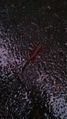
I'm totally not sad, though, because we got to see this newt.

Achievements
Frogman (talk) earned the Drag-along achievement
|