Difference between revisions of "2022-04-16 49 7"
(DLichti's report) |
(DLichti's photos) |
||
| Line 1: | Line 1: | ||
| − | + | {{meetup graticule | |
| − | |||
| − | |||
| − | |||
| − | |||
| − | |||
| − | |||
| − | |||
| − | |||
| lat={{#explode:{{SUBPAGENAME}}| |1}} | | lat={{#explode:{{SUBPAGENAME}}| |1}} | ||
| lon={{#explode:{{SUBPAGENAME}}| |2}} | | lon={{#explode:{{SUBPAGENAME}}| |2}} | ||
| date={{#explode:{{SUBPAGENAME}}| |0}} | | date={{#explode:{{SUBPAGENAME}}| |0}} | ||
| − | }} | + | }} |
__NOTOC__ | __NOTOC__ | ||
| Line 57: | Line 49: | ||
From there, we went back down and soon came back to our starting point. | From there, we went back down and soon came back to our starting point. | ||
| − | + | == Photos == | |
| + | |||
| + | === DLichti === | ||
| − | |||
| − | |||
| − | |||
| − | |||
<gallery perrow="5"> | <gallery perrow="5"> | ||
| + | Image:2022-04-16 49 7 Friedhof.jpeg | The jewish cemetary | ||
| + | Image:2022-04-16 49 7 Bühlsteine.jpg | One of the Bühlsteine | ||
| + | Image:2022-04-16 49 7 Kapelle.jpg | Saint Gertrudi's chapel | ||
| + | Image:2022-04-16 49 7 Hash tree.jpg | A hash tree | ||
| + | Image:2022-04-16 49 7 proof.png | proof | ||
| + | Image:2022-04-16 49 7 hat.jpg | The hat was there. | ||
| + | Image:2022-04-16 49 7 Heidenpfeiler.jpg | View from the Heidenpfeiler | ||
</gallery> | </gallery> | ||
| Line 78: | Line 75: | ||
<!-- Potential categories. Please include all the ones appropriate to your expedition --> | <!-- Potential categories. Please include all the ones appropriate to your expedition --> | ||
| − | |||
| − | |||
| − | |||
| − | |||
| − | |||
[[Category:Expeditions]] | [[Category:Expeditions]] | ||
| − | + | [[Category:Coordinates reached]] | |
[[Category:Expeditions with photos]] | [[Category:Expeditions with photos]] | ||
| − | |||
| − | |||
| − | |||
| − | |||
| − | |||
| − | |||
| − | |||
| − | |||
| − | |||
| − | |||
| − | |||
| − | |||
| − | |||
| − | |||
| − | |||
| − | |||
| − | |||
| − | |||
| − | |||
| − | |||
| − | |||
| − | |||
| − | |||
| − | |||
Revision as of 16:30, 16 April 2022
| Sat 16 Apr 2022 in 49,7: 49.1154182, 7.8585289 geohashing.info google osm bing/os kml crox |
Location
In the forest near Erlenbach.
Participants
- DLichti is planning to go for a walk with his parents.
- Baarde wants to cycle there in the afternoon.
Plans
DLichti
Take the car to Weißensteinerhof in the early afternoon. Visit the Bühlersteine, the hash point and Heidenberg.
Baarde
I will cycle from Wissembourg to Erlenbach. I expect to be at the coordinates around 14:30.
Expedition
DLichti
We left the car at the parking near the jewish cemetary just outside Busenberg at around 12:45. It was a very nice weather, fresh an sunny. Our first goal were the Bühlsteine (a.k.a. Buhlsteine, Puhlsteine), a rocky ridge overlooking the pass between the valleys of the Erlenbach and the Wieslauter. We met quite a few groups of rock climbers all along that ridge. From the southern end, we could already look down on the approximate geohash location.
Back down in the valley, we came be a small chapel. From there, it was not far to the location, and we were in good time. Just before arriving to the closest road-reachable point, we saw a man in the distance, on a bike, holding a phone and suspiciously looking into the general direction of the geohash. It soon turned out to be Baarde.
While he looked for a more appropriate approach by bike from the other side, we stepped right through the meadow. The location turned out to be close to an old tree. We arrived there almost simultaneous at around 14:30, just as planned. It was a nice time, getting to know each other and sharing some cookies.
After half an hour, Baarde had to leave to get back to his train. We continued on our way to the Heidenberg. There were very nice views on the surrounding hills and valleys with their castles and villages to be had from the Heidenfels and Buchkammerfels. The latter one has some carved chambers, which allegedly were used to hide the treasures of the nearby Drachenfels. From there, we went back down and soon came back to our starting point.
Photos
DLichti
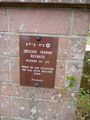
The jewish cemetary
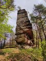
One of the Bühlsteine
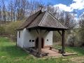
Saint Gertrudi's chapel
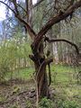
A hash tree
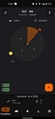
proof
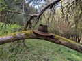
The hat was there.
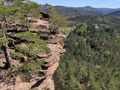
View from the Heidenpfeiler


